Map
Future Land Use Map
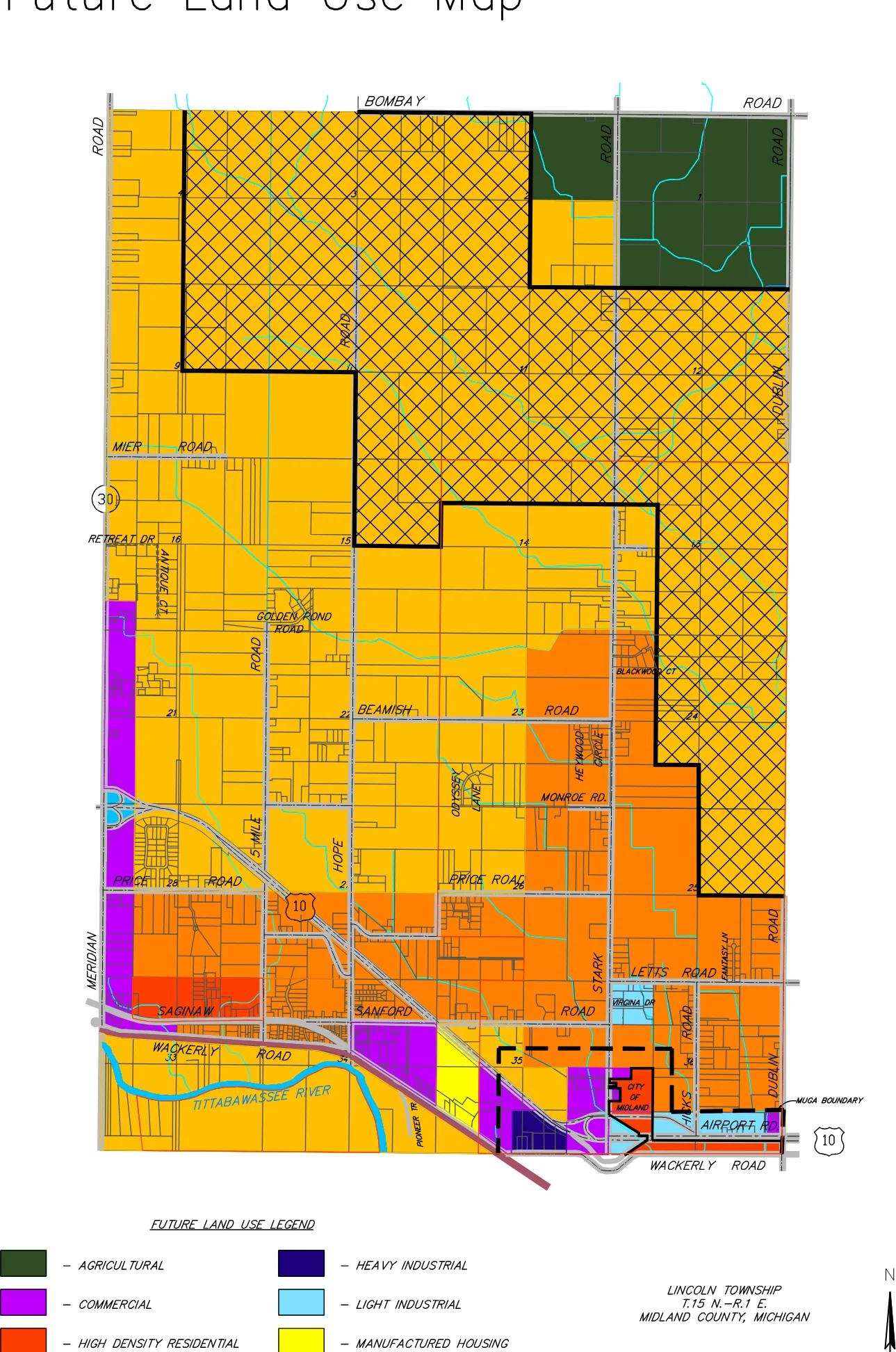
Map of Lincoln Township, Midland County, showing planned future land use districts such as rural residential, low and high density residential, commercial, industrial, agricultural and state forest areas.
Summary written automatically. The full text below is the record.
Future Land Use Map
 (opens the full-size map in a new tab)
Read a text description of this map
Map of Lincoln Township (T.15 N.-R.1 E.), Midland County, Michigan, north up. Bombay Road runs along the north edge; Wackerly Road and US-10 along the south; Meridian Road on the west and Dublin Road on the east. Other labeled roads include Mier Road, Beamish Road, Price Road, Monroe Road, Saginaw Road, Sanford Road, Letts Road, Stark Road, Hicks Road, Airport Road, 5 Mile Road, Hope Road, Golden Pond Road, Heywood Circle, Odyssey Lane, Blackwood Ct, Fantasy Ln, Virginia Dr, Pioneer Tr, Retreat Dr and Antique Ct; M-30 is at the west. Most of the township is Rural Residential. A large Ausable State Forest Area (crosshatched) occupies the northern and northeastern central part. Agricultural land is in the northeast corner, north of the forest area. Low Density Residential (orange) covers a band across the south of the township, from Price Road down to Saginaw and Sanford Roads, and the east-central area from about Blackwood Ct south to Letts Road, between Stark Road and the state forest area. South of Wackerly Road and the river the land is Rural Residential again. Small High Density Residential areas lie near Saginaw Road in the southwest and next to the City of Midland in the south-east. Commercial (purple) runs in a strip along Meridian Road on the west side, and appears near the southern US-10 corridor and near the City of Midland. Manufactured Housing (yellow) is a small area south of Sanford Road near Pioneer Tr. Heavy Industrial is a small area in the south near US-10 west of the City of Midland; Light Industrial areas are near Virginia Dr, Airport Road and the southeast corner. The Tittabawassee River runs through the southwest. The Pere Marquette Rails to Trails runs diagonally southeast across the south. A dashed line marks the MUGA boundary near the City of Midland in the south-east. Section numbers are shown.
Future Land Use Legend
- Agricultural
- Commercial
- High Density Residential
- Low Density Residential
- Rural Residential
- Heavy Industrial
- Light Industrial
- Manufactured Housing
- Ausable State Forest Area
- Pere Marquette Rails to Trails
- Water
Lincoln Township T.15 N.-R.1 E. Midland County, Michigan
Revised By: ROWE Professional Services Company