Map
Lincoln Township Zoning Map — July 2025
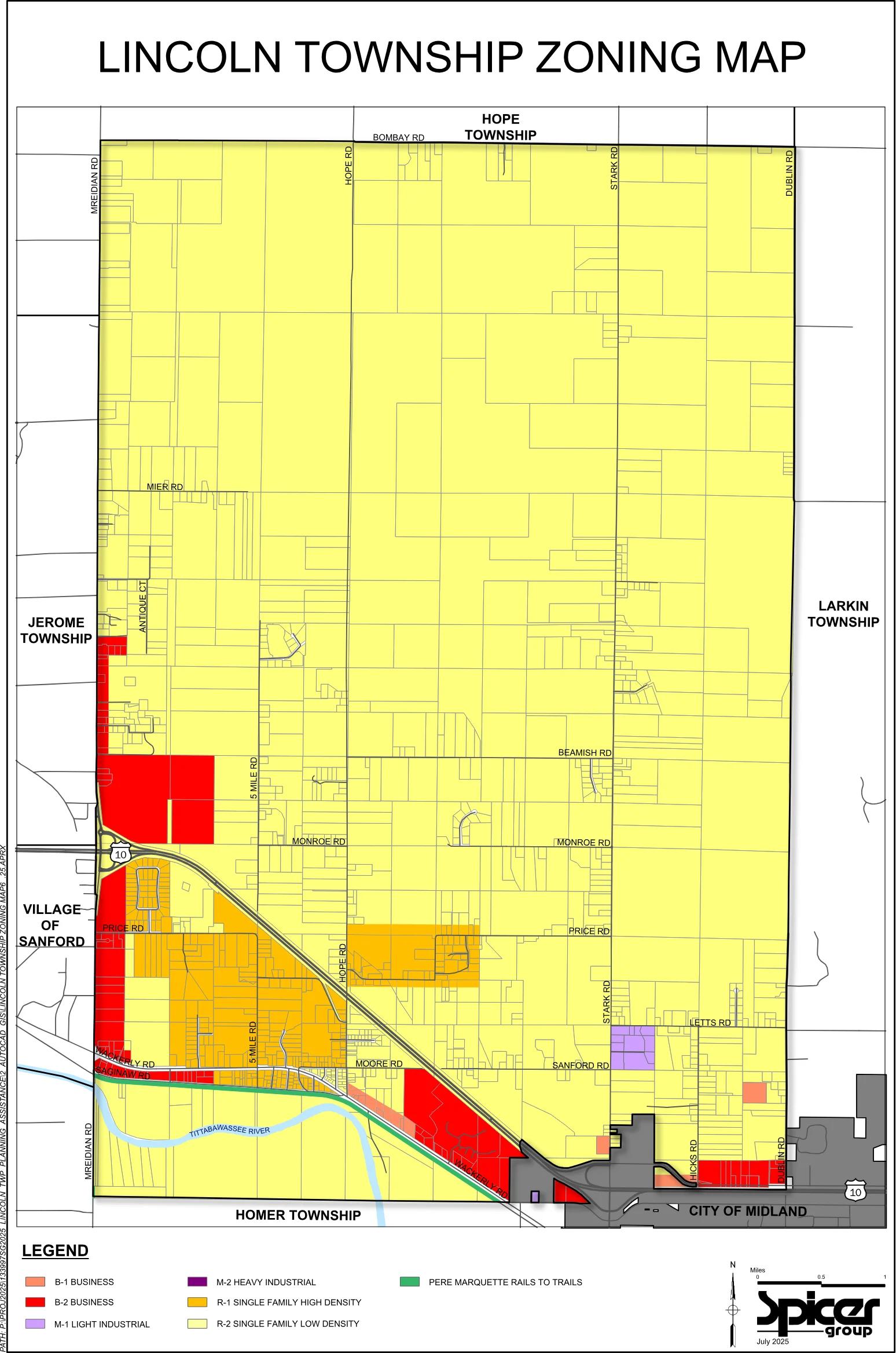
A one-page color map of Lincoln Township's zoning districts, dated July 2025 and prepared by Spicer Group. Most of the township is R-2 single family low density, with business and higher-density residential areas in the southwest.
Summary written automatically. The full text below is the record.
Lincoln Township Zoning Map
 (opens the full-size map in a new tab)
Read a text description of this map
Zoning map of Lincoln Township, north at top. Neighbors: Hope Township to the north (Bombay Rd), Larkin Township to the east, Homer Township to the south, Jerome Township and the Village of Sanford to the west, and the City of Midland (shown gray) at the southeast corner. North-south roads labeled: Mreidian Rd (west edge), 5 Mile Rd, Hope Rd, Stark Rd, Hicks Rd and Dublin Rd (east edge). East-west roads labeled: Bombay Rd, Mier Rd, Monroe Rd, Beamish Rd, Price Rd, Letts Rd, Sanford Rd, Moore Rd, Wackerly Rd and Saginaw Rd. Antique Ct is also labeled. US-10 runs diagonally from the west edge near Monroe Rd southeast to the City of Midland, and runs east-west through Midland. The Tittabawassee River crosses the southwest, south of Saginaw Rd. The vast majority of the township, especially the entire northern part, is R-2 Single Family Low Density (pale yellow). R-1 Single Family High Density (orange) lies in the southwest: around Price Rd and 5 Mile Rd south of US-10's bend, east of the west edge, plus a block east of Hope Rd, reaching about halfway to Stark Rd, on both sides of Price Rd. B-2 Business (red) runs along the west edge from north of Antique Ct to Wackerly Rd, with larger blocks just north of US-10 near the west edge, along Saginaw Rd, and a large area along US-10 and Wackerly Rd southeast of Hope Rd, plus a small area at the southeast near Dublin Rd and US-10. B-1 Business (salmon) appears in small patches along Wackerly Rd southeast of Moore Rd, near Stark Rd and Hicks Rd in the southeast, and west of Dublin Rd south of Letts Rd. M-1 Light Industrial (lavender) is a block just east of Stark Rd between Letts Rd and Sanford Rd. M-2 Heavy Industrial (purple) is a very small parcel near the southern border by the City of Midland. The Pere Marquette Rails to Trails (green) runs along the south side of Saginaw Rd and Wackerly Rd diagonally to the southeast. Scale bar 0 to 1 mile; north arrow; credited to Spicer Group, July 2025.
Legend
- B-1 Business
- B-2 Business
- M-1 Light Industrial
- M-2 Heavy Industrial
- R-1 Single Family High Density
- R-2 Single Family Low Density
- Pere Marquette Rails to Trails
Spicer Group. July 2025.