Ordinance
Lincoln Township Zoning Ordinance (Revised May 2025)
The Lincoln Township Zoning Ordinance, revised May 2025, sets up the township's zoning districts and the rules for how land and buildings may be used. It covers definitions, general requirements, parking, signs, land use districts, special land use permits, site plan review and administration, and includes a procedures manual with application forms.
Summary written automatically. The full text below is the record.
Contents (128)
LINCOLN TOWNSHIP
Zoning Ordinance
Lincoln Township, Midland County, Michigan
Township Hall Address
1882 N. Hope Road
Midland, MI 48642
Phone: (989) 374-2220
Revised May 2025
Lincoln Township Planning Commission
- Jamie Crockett, Chair
- Andrew Acker, Vice Chair
- Reid Duford, Secretary
- Dave Dauer
- Brad Wirtz
Lincoln Township Board Of Trustees
- Brett Fales, Supervisor
- Barbara Wilson, Clerk
- Kimberly Oswald, Treasurer
- Nate Meredith, Trustee
- Brad Wirtz, Trustee
Table of Contents
| Section | Title | Chapter-Page |
|---|---|---|
| Chapter 1 | General Provisions | 1-1 |
| Section 1.1 | Title and Purpose | 1-1 |
| Section 1.2 | Short Title | 1-1 |
| Section 1.3 | Purpose | 1-1 |
| Section 1.4 | Conflicts with Other Laws. | 1-2 |
| Section 1.5 | Severability | 1-2 |
| Section 1.6 | Repealing Clause | 1-2 |
| Section 1.7 | Effective Date | 1-2 |
| Chapter 2 | Definitions | 2-1 |
| Section 2.1 | Rules Applying to the Text | 2-1 |
| Section 2.2 | Definitions | 2-1 |
| Chapter 3 | General Requirements | 3-1 |
| Section 3.1 | Scope of Regulations | 3-1 |
| Section 3.2 | Nonconforming Uses | 3-1 |
| Section 3.3 | Supplementary Use Regulations | 3-2 |
| Section 3.4 | Dwelling Regulations | 3-10 |
| Section 3.5 | Home Occupation | 3-11 |
| Section 3.6 | Supplementary Yard Regulations | 3-11 |
| Section 3.7 | Supplementary Height Regulations | 3-12 |
| Section 3.8 | Accessory Buildings | 3-13 |
| Section 3.9 | Required Water Supply and Wastewater Disposal Facilities | 3-16 |
| Section 3.10 | Animals and Fowl Other Than Household Pets | 3-16 |
| Section 3.11 | Dangerous and Abandoned Buildings | 3-16 |
| Chapter 4 | General Off-Street Parking and Loading | 4-1 |
| Section 4.1 | Purpose and Intent | 4-1 |
| Section 4.2 | Off Street Parking and Loading Requirements | 4-1 |
| Section 4.3 | Site Development and Construction Requirements | 4-3 |
| Section 4.4 | Off Street Parking Requirements | 4-4 |
| Section 4.5 | Permit | 4-6 |
| Section 4.6 | Loading Requirements | 4-6 |
| Section 4.7 | Lighting | 4-6 |
| Table 1 - Permitted Lighting Types and Required Shielding | 4-7 | |
| Chapter 5 | Sign Regulations | 5-1 |
| Section 5.1 | Intent and Purpose. | 5-1 |
| Section 5.2 | Temporary Signs | 5-1 |
| Section 5.3 | Exemptions | 5-2 |
| Section 5.4 | Nonconforming Signs | 5-3 |
| Section 5.5 | Prohibited Signs | 5-3 |
| Section 5.6 | Illumination | 5-5 |
| Section | Title | Chapter-Page |
|---|---|---|
| Section 5.7 | Structural Requirements | 5-5 |
| Section 5.8 | Permit | 5-5 |
| Section 5.9 | Inspection, Removal, Safety | 5-6 |
| Table 2 - Signs Permitted By District | 5-7 | |
| Chapter 6 | Land Use Districts | 6-1 |
| Section 6.1 | Division of the Township | 6-1 |
| Section 6.2 | Official Zoning Map | 6-1 |
| Section 6.3 | Interpretation of Boundaries | 6-1 |
| Section 6.4 | Scope of Regulations | 6-1 |
| Map 1 - Zoning Map | 6-2 | |
| Table 3 - Intent and Purpose of Districts | 6-3 | |
| Table 4 - Uses for all Districts | 6-4 | |
| Table 5 - Dimensions for all Districts | 6-7 | |
| Table 6 - Uses - R-1 District | 6-8 | |
| Table 7 - Dimensions - R-1 District | 6-8 | |
| Table 8 - Uses - R-2 District | 6-9 | |
| Table 9 - Dimensions - R-2 District | 6-9 | |
| Table 10 - Uses - B-1 District | 6-10 | |
| Table 11 - Dimensions - B-1 District | 6-10 | |
| Table 12 - Uses - B-2 District | 6-11 | |
| Table 13 - Dimensions - B-2 District | 6-11 | |
| Table 14 - Uses - Light Industrial District, M-1 | 6-12 | |
| Table 15 - Dimensions - M-1 District | 6-12 | |
| Table 16 - Uses M-2 District | 6-13 | |
| Table 17 - Dimensions - M-2 District | 6-13 | |
| Section 6.5 | General Use Requirements | 6-14 |
| Chapter 7 | Special Land Use Permit Requirements | 7-1 |
| Section 7.1 | Intent and Purpose | 7-1 |
| Section 7.2 | Permit Procedures | 7-1 |
| Section 7.3 | Automobile Car Wash, Restaurants, Bars, Taverns, Commercial Recreation | 7-4 |
| Section 7.4 | Cemeteries | 7-5 |
| Section 7.5 | Day Nurseries | 7-5 |
| Section 7.6 | Funeral Homes, Clubs, Halls | 7-5 |
| Section 7.7 | Golf Courses, Country Clubs and Parks | 7-5 |
| Section 7.8 | Hospitals | 7-6 |
| Section 7.9 | Industrial Park | 7-6 |
| Section 7.10 | Institutional Uses Including Provision for the Mentally Impaired, Drug and Alcoholic Patients. | 7-9 |
| Section 7.11 | Manufactured Housing Parks | 7-9 |
| Section 7.12 | Motel and Hotel, Multiple Family Dwellings, Public Buildings | 7-13 |
| Section 7.13 | Planned Unit Development | 7-13 |
| Section 7.14 | Public Utility Buildings, Telephone Exchange Buildings, Electric Transformer Stations and Substations and Gas Regulator Stations, but not including Storage |
| Section | Title | Chapter-Page |
|---|---|---|
| Yards | 7-14 | |
| Section 7.15 | Religious Institutions, Temporary Outdoor Uses | 7-14 |
| Section 7.16 | Sewage Treatment and Disposal, Commercial Cleaning Plants, Salvage Yard and Resource Recovery Facilities, Storage of Waste Disposal Vehicles | 7-15 |
| Section 7.17 | Sexually Oriented Businesses and Adult Media Stores | 7-16 |
| Section 7.18 | Soil Resource Extraction, Pond Construction | 7-18 |
| Section 7.19 | Solar Energy Facilities | 7-18 |
| Section 7.20 | State Licensed Residential Facility | 7-24 |
| Section 7.21 | Tattoo and Piercing Parlor | 7-25 |
| Section 7.22 | Wireless Communication Facilities | 7-25 |
| Chapter 8 | Site Plan Review | 8-1 |
| Section 8.1 | Purpose | 8-1 |
| Section 8.2 | Scope | 8-1 |
| Section 8.3 | Application Procedure | 8-1 |
| Section 8.4 | Action on Application and Plans | 8-2 |
| Section 8.5 | Criteria for Review | 8-3 |
| Section 8.6 | Conformity to Approved Site Plan | 8-5 |
| Section 8.7 | Amendment to Site Plan | 8-5 |
| Section 8.8 | Performance Bond | 8-5 |
| Chapter 9 | Administration | 9-1 |
| Section 9.1 | General Administration | 9-1 |
| Section 9.2 | Duties of the Zoning Administrator | 9-1 |
| Section 9.3 | Amending the Zoning Ordinance | 9-3 |
| Section 9.4 | Zoning Board of Appeals | 9-4 |
| Section 9.5 | Terms of Office | 9-5 |
| Section 9.6 | Board of Appeals Procedures | 9-5 |
| Section 9.7 | Duties | 9-5 |
| Section 9.8 | Limitations | 9-7 |
| Section 9.9 | Appeals | 9-7 |
| Title | Page |
|---|---|
| Procedures Manual - Draft | PM-1 |
| IMPORTANT DATES - FEES | 108 |
| Planning Commission Meeting Dates | 108 |
| Zoning Board of Appeals Meeting Date | 108 |
| Comments | 108 |
| Special Accommodations | 108 |
| Fee Schedule | 108 |
| HOW TO SUBMIT A SITE PLAN FOR REVIEW | 109 |
| Materials to submit | 109 |
| Time line for review | 109 |
| Fees | 109 |
| How the process works | 109 |
| Application for Site Plan Review | 110 |
| Site Plan Review Checklist | 111 |
| Site Plan Review Flow Chart | 113 |
| HOW TO SUBMIT A SPECIAL USE PERMIT REQUEST | 114 |
| Material to submit | 114 |
| Time line for review | 114 |
| Fees | 114 |
| How the process works | 115 |
| Application for Special Use Permit | 116 |
| Special Land Use Review Flow Chart | 117 |
| HOW TO SUBMIT A REZONING REQUEST | 118 |
| Materials to submit | 118 |
| Time line for review | 118 |
| Fees | 118 |
| Application for Rezoning | 120 |
| Rezoning Flow Chart | 121 |
| HOW TO SUBMIT A ZBA REQUEST | 122 |
| Zoning Board of Appeals Application | 123 |
| Board Of Appeals Checklist | 124 |
| Flow Chart for Zoning Board of Appeals | 125 |
| MASTER PLAN ADOPTION/AMENDMENT FLOW CHART | 126 |
| ADMINISTRATIVE PROCESSES FLOW CHART | 127 |
| PUBLICATIONS | 128 |
| Requirements for Zoning Decisions | 128 |
| What to publish before the public hearing: | 130 |
| Whom to notify: | 130 |
| What to publish after adoption of an amendment: | 130 |
| Public Hearing Notice for Zoning Amendment or Map Change | 131 |
| Notice of Adoption of New Zoning Ordinance Text | 132 |
| Public Hearing Notice for Master Plan Amendment or Map Change | 133 |
| Notice of Intent to Plan | 134 |
| MISCELLANEOUS FORMS | 135 |
| Citizen Complaint Form | 135 |
| Title | Page |
|---|---|
| Fence Permit | 137 |
| Home Occupation Permit | 139 |
| Land Division Application | 140 |
| Mining Mineral Site Application | 143 |
| Mutual Access Agreement | 146 |
| Occupancy Permit | 150 |
| Performance Bond | 151 |
| Private Road Permit Application | 153 |
| Sign Permit Application – version A | 156 |
| Sign Permit Application – version B | 158 |
| Special Use Permit -Colocation – Attached Wireless Communication Facilities Application | 163 |
| Zoning Board of Appeals Final Decision and Form Minutes | 165 |
| Zoning Compliance Permit | 166 |
| Appendix - Links | AL-1 |
Chapter 1 General Provisions
Section 1.1 Title and Purpose
The Township of Lincoln, Midland County, Michigan, ordains:
AN ORDINANCE, pursuant with the provisions of Act 110 of Michigan Public Acts of 2006, as amended, to provide for the establishment in the Township of Lincoln, Midland County, Michigan, of zoning districts within which the proper use of land and natural resources may be encouraged or regulated, and within which districts provisions may also be adopted designating the location of, the size of, the uses that may be made of, the minimum open spaces, sanitary, safety, and protective measures that shall be required for, and the maximum number of families that may be housed in dwellings, buildings and structures, including tents and trailer coaches, that may be erected or altered; to provide for a method for the adoption of amendments thereto; to provide for the acquisition by purchase, condemnation or otherwise of nonconforming property; to provide for the administering of ordinances adopted; to provide for conflicts with other acts ordinances, or regulations; to provide penalties for violations; to provide for the assessment, levy and collection of taxes; to provide for the collection of fees for building permits; to provide for petitions, public hearings, and referenda; to provide for appeals; and to provide for the repeal of ordinances in conflict with this ordinance.
Section 1.2 Short Title
This ordinance shall be known as the Township of Lincoln Zoning Ordinance.
Section 1.3 Purpose
It is the general purpose of the Ordinance to provide for the establishment of zoning districts within which the proper use of land and natural resources may be encouraged and regulated, and further to:
- a.Promote the public health, safety and general welfare;
- b.Encourage the use of lands in accordance with their character and adaptability and to limit the improper use of land;
- c.Conserve natural resources and energy;
- d.Meet the needs of residents for food, fiber and other natural resources, places of residence, recreation, industry trade, service and other uses of the land;
- e.Insure that the uses of the land shall be situated in appropriate locations and relationships;
- f.Avoid overcrowding of the population;
- g.Provide adequate light and air;
- h.Lessen congestion on the public roads and streets;
- i.Reduce hazards to life and property;
- j.Facilitate adequate provision for a system of transportation, sewage disposal, safe and adequate water supply, education, recreation and other public requirements;
- k.Adopt provisions for each designated zoning district which shall control the use of land and property; the use, size, and location of buildings; the minimum yard, courts and other open spaces; and the maximum number of families to be housed in buildings or structures.
Section 1.4 Conflicts with Other Laws
The Township of Lincoln, Midland County, Michigan, Pursuant to the authority vested in it by Act 110 of Public Acts of the State of Michigan for 2006, as amended, hereby amends the “Lincoln Township Zoning Ordinance” to read as follows:
Whenever this Ordinance imposes a stricter requirement than other ordinances, then this Ordinance shall govern.
Section 1.5 Severability
Sections of this Ordinance shall be deemed to be severable and should any section, paragraph, or provisions hereof be declared by the courts to be unconstitutional or invalid, such holdings shall not affect the validity of the Ordinance as a whole or any part hereof, other than the part so declared to be unconstitutional or invalid.
Section 1.6 Repealing Clause
The Zoning Ordinance of Lincoln Township presently in effect and all amendments thereto, hereby are repealed; provided, however, if this Zoning Ordinance shall subsequently not be approved by public referendum or be judicially determined to have been unlawfully adopted, such public referendum or judicial determination shall then automatically reinstate the present Lincoln Township Zoning Ordinance and all of its amendments to their full affect.
Section 1.7 Effective Date
This Ordinance shall take effect December 8, 2011.
Chapter 2 Definitions
Section 2.1 Rules Applying to the Text
For the purposes of this Ordinance, certain rules of construction apply to the Text, as follows:
- a.Words used in the present tense include the future tense, and the singular includes the plural, unless the context clearly indicated the contrary.
- b.The word “person” includes a corporation or firm as well as an individual.
- c.The word “lot” includes the word “plot”, “tract”, or “parcel”.
- d.The term “shall” is always mandatory and not discretionary; the word “may” is permissive.
- e.The term “used” or “occupied” as applied to any land or structure shall be construed to include the words “intended, arranged or designed to be used or occupied”.
- f.Any word or term not herein defined shall be used with a meaning of common standard use.
Section 2.2 Definitions
ABUT. To physically touch or border upon; to share a common property line.
ACCESSORY STRUCTURE. A structure attached or detached from a principal building on the same lot and customarily incidental to and subordinate to the principal building or use.
ACCESSORY USE. Any accessory use includes a building or structure and is a use clearly incidental to, customarily found in connection with, and located on the same lot as the principle use to which it is related.
ADULT CABARET. A building or portion of a building regularly featuring dancing or other live entertainment if the dancing or entertainment that constitutes the primary live entertainment is distinguished or characterized by an emphasis on the exhibition of specific sexual activities or specified anatomical areas for observation by patron therein.
ADULT MEDIA. Magazines, books, slides, digital media or other devices used to record computer images, or other media that are distinguished or characterized by their emphasis on matter depicting, describing, or relating to hard-core material.
ADULT MEDIA STORE. An establishment that rents and/or sells media, and that meets any of the following three tests:
- a.40 percent or more of the gross public floor area is devoted to adult media.
- b.40 percent or more of the stock in trade consists of adult media.
- c.It advertises or holds itself out in any form as “XXX,” “adult,” “sex,” or otherwise as a sexually oriented business other than adult media store, adult motion picture theater or adult cabaret.
ADULT MOTION PICTURE THEATER. An establishment emphasizing or predominately showing sexually oriented movies.
ALLEY. Any dedicated public way other than a street which provides only a secondary means of access to abutting property and is not intended for general traffic circulation.
ANIMAL, DOMESTIC. Any animal normally and customarily kept by a domestic household for pleasure and companionship. Examples of domestic animals include domestic breeds of dogs, cats and animals confined to cages throughout their lifetime. A domestic animal excludes exotic and farm animals as defined by this ordinance.
ANIMAL, FARM. Any animal customarily found in farming operations such as but not limited to all breeds of horses, cows, goats, pheasants, chickens, ducks, geese, sheep, swine (as per City ordinance #1519, Chapter 3) or any other type of poultry or fowl. A farm animal shall also include all animals classified as livestock by the State of Michigan. A farm animal shall not include fish.
ANIMAL HOSPITAL. A place where animals or pets are given medical or surgical treatment and are cared for during the time of such treatment. Use as a kennel shall be limited to short-time boarding and shall be only incidental to such hospital use.
ANIMAL, WILD OR EXOTIC. Any of the following class or classes of animals; all marsupials (such as kangaroos and opossums); all non-human primates (such as gorillas and monkeys); all feline, except the domestic cat; all canine, except the domestic dog; all viverrine (such as mongooses and civets); all musteline (such as minks, weasels, otters and badgers but excluding a domesticated ferret); all ursine (bears); all ungulate artiodactyla and perissodactyla, except goats, sheep, pigs and cattle (such as deer, camels, hippopotamuses and elephants); all hyaena all pinniped (such as seals and walruses); all venomous snakes and all snakes of the families Boidae and Pythonidae; all venomous lizards; all ratite birds (such as ostriches); all diurnal and nocturnal raptorial birds (such as eagles, hawks and owls); all edentates (such as anteaters, sloths and armadillos); all bats; all crocodilian (such as alligators and crocodiles); and all venomous arachnids and spiders (such as tarantulas, scorpions and mites); all turtles in the families Chelydridae, Dermochelyidae, and Cheloniidae; wild or non-domesticated animals, whether or not raised or kept in captivity, and includes, but is not limited to, wolf, bobcat or mountain lion, fox, cougar, skunk, and all birds, the keeping of which is prohibited in the Migratory Birds Convention Act, 1994, c.22, and regulations thereto, and all animals, the keeping of which is prohibited in the Fish and Wildlife Conservation Act, 1997, c.41, and regulations.
AUTOMOBILE CAR WASH. An establishment being housed in a building or portion thereof, together with the necessary mechanical equipment used for washing automobiles.
AUTOMOBILE OR VEHICLE SALES AREA. An area used for the display, sales and rental of new and used motor vehicles, boats, trailers, farm equipment, construction equipment or mobile homes all in operable condition.
AUTOMOBILE REPAIR SHOP. An establishment being housed in a building or portion thereof, together with the necessary equipment used for general repair of automobiles, engine rebuilding, rebuilding or reconditioning of motor vehicles, collision service and painting or undercoating of automobiles.
AUTOMOBILE SERVICE STATION. An establishment being housed in a building or portion thereof, together with the necessary equipment used for the direct retail sale of gasoline or any other engine fuel, kerosene, or motor oil and lubricants or grease and including the sale of minor accessories, and the servicing of and minor repair of automobiles.
BANK. A building designed to perform one or more services, including, but not limited to, the safeguarding of money and other valuables, the lending of money, the executing of bills of exchange such as checks, drafts and money orders, the issuance of notes, and the receipts of funds. The term ‘bank” includes, but is not limited to, banks, savings and loan operations, and credit unions.
BAR. A structure or part of a structure used primarily for the sale or dispensing of alcoholic beverages by the drink.
BASEMENT. A story of a building having part not more than one-half (1/2) of its height above finished grade. A basement shall be counted as a story for the purpose of height measurement if the vertical distance between the ceiling and the average level of the adjoining ground is more than five (5`) feet or if used for business or dwelling purposes.
BERM. An earthen buffer that obscures sight, traffic and sound.
BODY SHOP. See AUTOMOBILE/VEHICLE REPAIR.
BUFFER. A buffer may be open spaces, landscaped areas, fences, walls, berms and/or combination thereof used to physically separate or screen one use or property from another so as to visually shield or block noise, lights or other nuisances. Types of buffers required are regulated separately in this Ordinance.
BUILDING. Any structure having a roof supported by columns or by walls and intended for the shelter, housing, or enclosure of persons, animals, or property. This shall include tents and trailer coaches.
BUILDING, HEIGHT OF. The vertical distance measured from the mean elevation of the finished grade line of the ground about the front of the building to the highest point of the roof for flat roofs; to the deck line of mansard roofs; and to the mean height level between eaves and ridge for gable, hip and gambrel roofs.
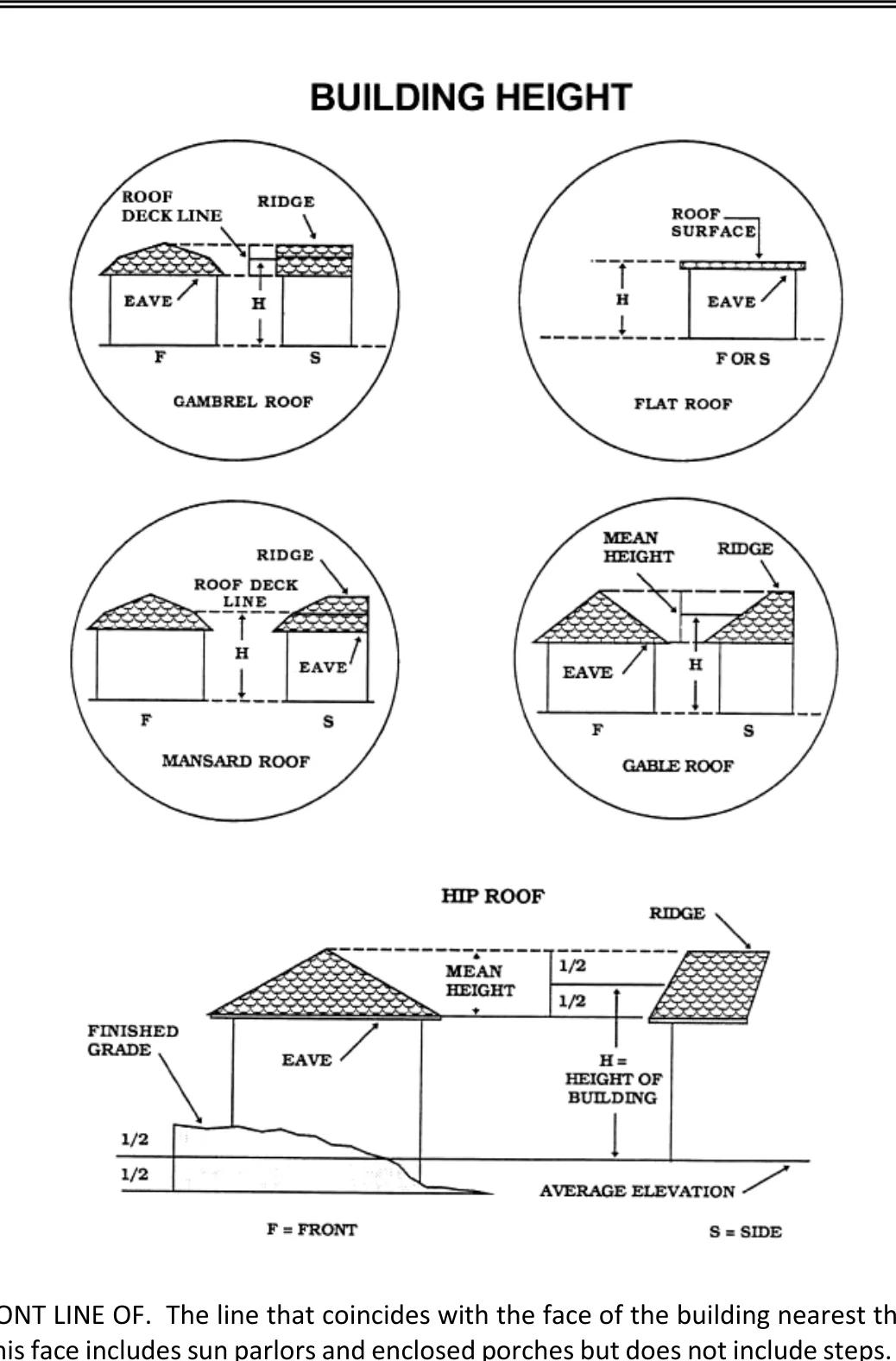 (opens the full-size diagram in a new tab)
Read a text description of this diagram
BUILDING, FRONT LINE OF. The line that coincides with the face of the building nearest the front line of the lot. This face includes sun parlors and enclosed porches but does not include steps. Said line shall be parallel to the front lot line and measure as a straight line between the intersection points with the side yard.
BUILDING LINES. A line defining the minimum front, side or rear yard requirements outside of which no building or structure may be located.
BUILDING, PRINCIPAL. A building in which is conducted the main or principal use of the lot on which it is located.
CARPORT. A temporary or permanent roofed structure, open on at least one side designed for occupancy by a private passenger vehicle.
CEMETERY. Any publicly or privately owned place for the interment of human remains.
CLINIC. An establishment where human patients who are not lodged overnight are admitted for examination and treatment by a group of physicians, dentists or similar professionals.
CLUB. An organization catering exclusively to members and their guests, or premises and buildings for recreational, artistic, political, or social purposes, which are not conducted primarily for gain and which do not provide merchandise, vending, or commercial activities; except as required incidentally for the membership and purpose of such club.
COMMERCIAL. See RECREATIONAL USE, COMMERCIAL.
COMMON DRIVE. A driveway used by two residences or two or more commercial or industrial uses.
COMMON LAND. A parcel or parcels of land together with the improvements thereon, the use, maintenance, and enjoyment of which are intended to be shared by the owners and occupants of the individual building units in a planned unit development.
CONDOMINIUM ACT. Act 59 of 1978, as amended.
CONDOMINIUM, EXPANDABLE. A condominium project to which additional land may be added pursuant to express provisions in the condominium documents and in accordance with this Ordinance and the Condominium Act.
CONDOMINIUM SUBDIVISION. See SUBDIVISION.
CONDOMINIUM SUBDIVISION PLAN. The site, survey, and utility plans, floor plans and sections, showing the existing and proposed structures and improvements.
CONDOMINIUM UNIT. That portion of the condominium project designed and intended for separate ownership and use, as described in the master deed, regardless of whether it is intended for residential, office, industrial, business, recreational, use as a time-share unit, or any other type of use.
CONSOLIDATED MASTER DEED. The final amended master deed for a contractible condominium project, expandable condominium project, or a condominium project containing convertible land or convertible space, which final amended master deed fully describes the condominium project as completed.
CONTRACTIBLE CONDOMINIUM. A condominium project from which any portion of the submitted land or buildings may be withdrawn pursuant to the express provision in the condominium documents and in accordance with this Ordinance and the Condominium Act.
CONTRACTOR’S STORAGE YARD. An unenclosed portion of the lot or parcel upon which a construction contractor maintains its principal office or a permanent business office. Designation of the lot or parcel as a contractor’s storage yard would allow this area to be used to store and maintain
construction equipment and other materials customarily used in the trade carried on by the construction contractor. If permitted to be used in this manner, the entire lot or parcel would then be classified as a “contractor’s storage yard” and will be required to conform to all applicable zoning district standards and other legislative regulations.
COVERAGE, LOT. That percent of the plot or lot covered by the building area.
CUL DE SAC. A street with only one outlet having sufficient space at the closed end to provide a vehicular turning area.
DAY NURSERY. A private establishment enrolling four or more children where tuition, fees, or other forms of compensation for the care of children is charged, and which is licensed or approved to operate as a child care center.
DEGREE OF NONCONFORMANCE. A measure of a property's relative lack of conformance, to be computed using whichever of the following standards applies.
- a.USE. A Use is any item listed in the DISTRICT REGULATIONS chapters of this Ordinance as allowed by Right or by Special Use Permit.
- b.SETBACK. The square footage of a building that is within a required setback area.
- c.AREA. The square footage by which a building or parcel varies from the maximum or minimum area required for its Zoning District.
- d.WIDTH OR DEPTH. The distance in feet by which the width or depth of a parcel varies from the minimum or maximum dimension for its Zoning District.
- e.PARKING. The number of off street parking spaces which a parcel lacks to conform to the requirements of the Zoning Ordinance.
DENSITY. The number of dwelling units situated on or to be developed upon gross acre of land. Low density is one dwelling unit per acre. Medium density is 2 to 4 dwelling units per acre.
DEPTH. Depth is the distance from a property line to a structure.
DRIVE-IN. A business establishment so developed that its retail or service character is dependent on providing a drive-way approach or parking space for motor vehicles so as to serve patrons while in their motor vehicles, or within a building on the same premises and devoted to the same purpose as the drive-in service.
DWELLING-SINGLE FAMILY. A building or portion thereof, designed for occupancy by one (1) family for residential purposes and having interior cooking facilities.
DWELLING-TWO FAMILY. A two family dwelling is a detached residential building containing two (2) dwelling units, designed for occupancy by not more than two (2) families. These may also be known as duplexes.
DWELLING-MULTIPLE FAMILY. A multiple family dwelling is a residential building designed for or occupied by three (3) or more families with the number of families in residence not exceeding the number of dwelling units provided.
ESSENTIAL SERVICES. The erection, construction, alteration or maintenance of underground surface or overhead electrical gas, water and sewage transmission and collection systems and the equipment and appurtenances necessary for such systems to furnish an adequate level of public service.
EXPLICIT SEXUAL MATERIAL. Any hard core material.
FAMILY. An individual, two or more persons related by blood, marriage or adoption, living together as a housekeeping unit in a dwelling unit or a group of not more than four (4) persons, who need not be related, living together as a single housekeeping unit.
FARM. A tract of land which is directly devoted to agricultural purposes including establishments operated as greenhouses, nurseries, orchards, chicken hatcheries or apiaries; but establishments keeping or operating fur-bearing animals, riding or boarding stables, kennels, quarries or gravel or sand pits shall not be considered farms hereunder unless combined with a bonafide farm operation on the same contiguous tract of land of not less than twenty acres (20). Feed lots do not fall under this definition.
FEED LOT (ANIMAL FEEDING OPERATION). A lot or building or combination of contiguous lots and buildings where animals have been, are, or will be stabled or confined and fed or maintained for a total of 45 days or more in any 12 month period, where manure may accumulate and where the concentration of animals is such that vegetative cover or post-harvest residues cannot be maintained within the enclosure during the normal growing season.
FENCE, DECORATIVE. A decorative fence is intended to enclose a parcel or portion of a parcel in a decorative manner and is not necessarily intended to preclude or inhibit entry or vision into the property. Examples of decorative fences include split rail, wrought iron and similar fences that are visually “transparent” and /or readily breached. The Building Inspector may determine that a fence is decorative and is thereby exempt from restrictions under the provisions of Chapter 3, Section 3.3 (i).
FENCE, FUNCTIONAL. A functional fence is intended to enclose a parcel or portion of a parcel to prevent or make difficult entry by animals, persons or vehicles. SUCH A FENCE MAY ALSO BE VISUAL SCREEN. Chain link, masonry, stockade and similar types of fences are examples of functional fences.
FUNERAL HOME. A building used for the preparation of the deceased for burial and display, and for ceremonies connected therewith before burial or cremation.
GAS/SERVICE STATION: A place where gasoline, kerosene, or any other motor fuel or lubricating oil or grease for operation of motor vehicles is offered for sale to the public and deliveries are made directly into motor vehicles, including sale of accessories, greasing, oiling, and light motor service on the premises, but in no case to include automobile or truck mechanical repair. Convenience food sales and/or fast food restaurants may also be provided on the premises.
GRAVEL PIT. An open land area where sand, gravel, and rock fragments are mined or excavated for sale or off-tract use.
GREENHOUSE. A temporary or permanent building whose roof and sides are made largely of glass or other transparent or translucent material, and in which the temperature and humidity can be regulated for the cultivation of delicate or out-of-season plants for subsequent sale or personal enjoyment.
GROSS FLOOR AREA. The sum of the gross horizontal areas of the several floors of a building measured from the exterior face of exterior walls, or from the center line of a wall separating two buildings, but not including interior parking spaces, loading spaces, loading space for motor vehicles, or any space where the floor-to-ceiling height is less than six feet. For the purposes of calculating parking and loading requirements, the gross floor area is the floor area used for service to the public. It shall not include floor area used solely for storage or processing and packaging of merchandise.
GROSS PUBLIC FLOOR AREA. The total area of the building accessible or visible to the public, including showrooms, motion picture theaters, motion picture or video arcades, service areas, behind-counter areas, storage areas visible from such other areas, restrooms (whether or not labeled “public”), areas used for cabaret or similar shows (including stage areas), plus aisles, hallways, and entryways serving such areas.
HARD-CORE MATERIAL. Media characterized by sexual activity that includes one or more of the following: erect male organ; contact of the mouth of one person with the genitals of another; penetration with a finger or male organ into any orifice in another person; open female labia; penetration of a sex toy into an orifice; male ejaculation; or the aftermath of male ejaculation.
HEAVY VEHICLE. Any commercial vehicle over 1.5 tons including trucks, buses, trailers, construction equipment and similar vehicles regardless of their road worthiness.
HEIGHT, MEASUREMENT OF. The height of a building, fence, or wall at any given level is the height above the natural grade of any portion or portions of a wall or walls along the length of the building. Natural grade level shall be the mean level of the ground immediately adjoining the portion or portions of the wall or walls along the total length of the building.
HOME OCCUPATION. Any business carried on by one or more members of family residing on the premises PROVIDED it:
- a.Be operated within the principal dwelling.
- b.Not more than one (1) employee not residing in the dwelling.
- c.All activities and storage shall be carried on indoors.
- d.Home occupations shall not be conducted in any accessory building or part thereof.
- e.Not use more than twenty-five (25%) percent of the total actual floor area of the dwelling.
HOSPITAL. An institution for the diagnosis, treatment or care of aged, sick or injured people. The term “hospital” shall include sanitarium, rest home, nursing home and convalescent home.
INDUSTRIAL PARK. A planned, coordinated development of a tract of land with two or more separate industrial buildings. Such development is planned, designed, constructed, and managed on an integrated and coordinated basis with special attention given to on-site vehicular circulation, parking, utility needs, building design, orientation, and open space.
INDUSTRIAL USES. A business use or activity at a scale greater than home industry involving manufacturing, fabrication, assembly, warehousing, and/or storage.
INSTITUTION, EDUCATIONAL. A school for kindergarten through twelfth grade or any colleges or universities authorized by the state to award degrees.
INSTITUTION, HUMAN CARE. A public or private facility for physical or mental care. A human care institution may include hospitals, convalescent or nursing homes, homes for the mentally or physically impaired, and mental, physical or substance abuse rehabilitation facilities.
INSTITUTION, RELIGIOUS. A structure or place in which worship, ceremonies, rituals and education pertaining to a particular system of beliefs are held.
INSTITUTION, SOCIAL. Any profit or nonprofit use or facility in which activities for leisure or philanthropy are carried out. Such institutions may include service clubs, scout organizations, hobby clubs and veterans’ organizations.
JUNK YARD. Any establishment or premises used for the purpose of dismantling, wrecking, disposing and/or storage of refuse materials of automobiles. Any premise upon which three (3) or more unlicensed motor vehicles which cannot be operated under their own power are kept or stored for a period of fifteen (125) days or more shall be deemed a junk yard within the meaning of this ordinance.
KENNEL. Any facility, on a single parcel, where more than three (3) dogs, three (3) cats, or other household pets, over four (4) months old are kept, housed or boarded for a fee, or where such animals are kept for breeding purposes.
LABORATORY. A building or group of buildings in which are located facilities for scientific research, investigation, testing, or experimentation, but not facilities for the manufacture or sale of products, except as incidental to the main purpose of the laboratory.
LINGERIE MODELING STUDIO. An establishment or business that provides the services of live models modeling lingerie to individuals, couples or small groups in rooms smaller than six hundred (600) square feet.
LOADING BERTH/SPACE. An off-street space at least ten feet (10) wide, twenty-five feet (25) long and fifteen feet (15) high; either within a building or outside on the same lot, provided, maintained and available for the loading or unloading of goods or merchandise and having direct and unobstructed access to a street or alley.
LOT. A parcel of land subject to the provision of this Ordinance and upon which a main building and accessory buildings may be constructed.
CORNER LOT. is a lot which has at least two (2) contiguous sides abutting upon a street for their full length, and PROVIDED the two (2) sides intersect at an angle of not more than one hundred thirty-five (135) degrees.
INTERIOR LOT. is a lot other than a corner lot.
THROUGH LOT. is an interior lot having frontage on two (2) streets which do not intersect at a point contiguous to such lot.
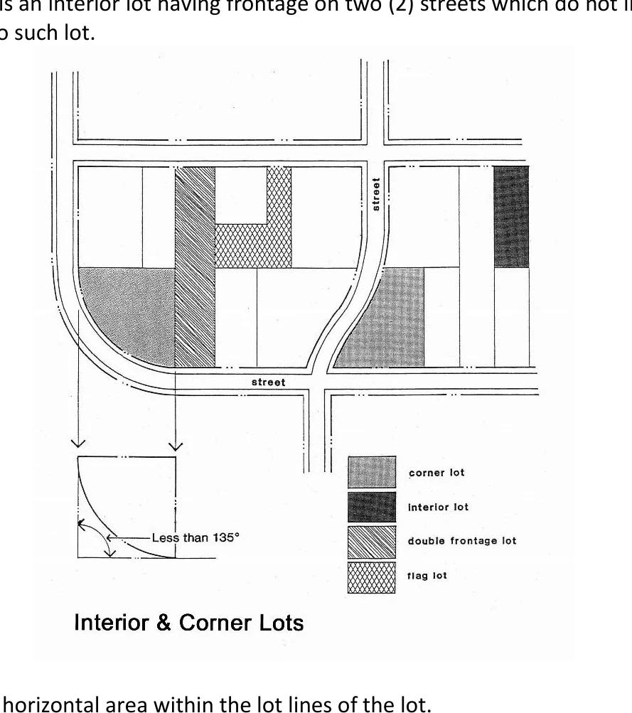 (opens the full-size diagram in a new tab)
Read a text description of this diagram
LOT AREA. The total horizontal area within the lot lines of the lot.
LOT LINE, FRONT. That line separating the lot from the street. In the case of a corner lot or through lot, the lines separating the lot from each street.
LOT LINE, REAR. Lot line which is opposite the front lot line. In the case of a corner lot, the rear lot line may be opposite either front lot line, but there shall only be one (1) rear lot line. In the case of a lot with side lot lines converging at the rear, the rear lot line shall be an imaginary line parallel to the front lot line, not less than twenty feet (20) long, lying farthest from the front lot line and wholly within the lot.
LOT LINE, SIDE. Any lot line not a front lot line or not a rear lot line.
LOT, WIDTH OF. The width measured along the front line or street line on an approved road.
LOT OF RECORD. A parcel of land, the dimensions of which are shown on a document or map on file with the Midland County Register of Deeds or in common use by county and community officials and which actually exists as shown; or, any part of such parcel held in a record of ownership separate from that of the remainder thereof.
MANUFACTURING. The mechanical or chemical transformation of materials or substances into new products, including the assembling of component parts, the manufacturing or products, and the blending of materials, such as lubricating oils, plastics, resins, or liquors.
MASSAGE STUDIO. An establishment offering massage therapy and/or body work by a massage therapist licensed under Michigan state law or under the direct supervision of a licensed physician.
MEDIA. Anything printed or written, or any picture, drawing, photograph, motion picture, film, video tape or videotape production, or pictorial representation or any electrical or electronic reproduction of anything that is or may be used as a means of communication. Media includes but shall not be necessarily limited to books, newspapers, magazines, movies, videos, sound recordings, CD-ROMs, other magnetic media and undeveloped pictures.
MEDIA SHOP. A general term, identifying a category of business that may include sexually oriented material but that is not subject to the special provisions applicable to adult media shops. IN that context, media shop means a retail outlet offering media for sale or rent, for consumption off the premises provided that any outlet meeting the definition of adult media shop be treated as an adult media outlet. See special conditions in Chapter 13, Special Use Permits, for media shops in which adult media constitute more than ten (10%) percent but less than forty (40%) percent of the stock in trade or occupy more than ten (10%) percent but less than forty (40%) percent of the floor area.
MINISTORAGE/INDIVIDUAL STORAGE FACILITY. A structure containing separate storage spaces of varying sizes leased or rented on an individual basis.
MOBILE HOME. A mobile home is a structure, transportable in one (1) or more sections, which is built on a chassis and designed to be used as a residential dwelling with permanent foundation, when connected to the required utilities, and includes the plumbing, heating, air-conditioning, and electrical systems contained in the structure, the construction of which shall comply with the U.S. Department of Housing and Urban Development (HUD) Mobile Home Construction and Safety Standards, CFR 24, Part 3280 which have been designed for and are intended to be employed as dwellings for residential occupancy on an extended, rather than transient basis.
MOBILE HOME PARK. A parcel of tract or land under the control of a person and upon which three (3) or more mobile homes are located on a continual non-recreational basis and which is offered to the public for the purpose regardless of whether a charge is made thereof, together with any building, structure, enclosure, street, equipment, or facility used or intended for use incident to the occupancy of a mobile home and which is not intended for use as a temporary trailer park.
MOBILE HOME SPACE. A plot or parcel of land within the Mobile Home Park designed to accommodate one (1) mobile home.
MOBILE HOME STAND. That part of an individual Mobile Home site which has been reserved for the placement of the Mobile Home, appurtenant structures, or additions.
MODULAR HOME. A fabricated, transportable building unit designed to be incorporated at a building site into a structure on a permanent foundation for residential use.
MOTEL. A building or group of buildings, whether detached or in connecting units, used as individual sleeping or dwelling units designed primarily to accommodate transients and their automobiles. The term “motel” shall include buildings designed as “auto courts”, “tourist courts”, “motor hotels” and similar appellations which are designed as integrated units of individual rooms under common ownership.
MUNICIPAL BUILDING. A structure housing and operation of Lincoln Township.
NIGHTCLUB. A commercial establishment dispensing alcoholic beverages for consumption on the premises and in which dancing and musical entertainment are permitted.
NONCONFORMING USE. A building, structure or use of land existing at the effective date of this Ordinance, or amendments thereto, and which does not conform to the regulations of the district or zone in which it is situated.
OFFICE. An office is a place of business in which professional services are rendered or management activities of an enterprise are carried out. All such activities take place inside a building. Office activities include, but are not limited to, law, medicine, dentistry, accounting or computer consulting, bookkeeping, tax preparation, insurance, securities brokerage, executive or managerial functions for any type of enterprise, workshop or studio for a graphic artist or photographer, studio for broadcast media, all aspects of a newspaper or publishing business except actual printing, binding or distribution centers, and a base of operation for salespeople which does not include storage or display of merchandise.
OPAQUE. Not pervious to light.
Outdoor Storage Container. An industrial, standardized, reusable, and portable metal container originally and specifically designed for the intermodal shipping of goods or commodities by transport on trucks, rail cars, and ships which is now used primarily for the storage of personal property and materials.
OUTDOOR USE, TEMPORARY. A use carried out in an open area or uncovered or temporary structure, which is disbanded when the designated time period, activity or use for which the temporary structure was erected, has ceased.
OUTDOOR USE, PERMANENT. A use carried out in an open area, uncovered or permanent structure. Permanent is defined by the building code.
PARK, RECREATIONAL. An open area designed for the active and/or passive use of the general public and which may or may not contain playground or exercise facilities and equipment.
PARKING SPACE. An off-street space of at least 18 x 10 size exclusive of necessary driveways, aisles or maneuvering areas suitable to accommodate one (1) motor vehicle and having direct unobstructed access to a street or alley.
PERSONAL SERVICE. Establishments primarily engaged in providing services involving the care of a person or his or her apparel, excluding tattoo and piercing parlors.
PLAT. A map of a subdivision of land.
POND. An artificially or naturally confined body of still water, less than one (1) acre in size, excluding swimming pools.
PRIMARY LIVE ENTERTAINMENT. On-site entertainment by live entertainers that characterizes the establishment, as determined (if necessary) from a pattern of advertising as well as actual performances.
PRINCIPAL USE. The main use or principal purpose to which the premises are devoted.
PRINT SHOP. A facility for the custom reproduction of written or graphic materials on a custom order basis for individuals or businesses.
PROCESSING FACILITY. A building or an enclosed space used for the collection and processing of recyclable material. “Processing” means the preparation of material for efficient shipment, or to an end-user’s specifications, by such means as baling, briquetting, compacting, flattening, grinding, crushing, mechanical sorting, shredding, cleaning, and remanufacturing.
PROFESSIONAL SERVICES. Services offered to the general public such as law, medicine, engineering, accounting, and architecture.
PUBLIC FACILITIES. Facilities which are owned and operated by a municipality, government agency, or publicly owned utility.
PUBLIC UTILITY. Any person, firm, corporation, municipal department or board, fully authorized to furnish to the public electricity, gas, steam, telephone, telegraph, cable television, transportation, water or sewerage services.
RECREATION, COMMERCIAL. Any establishment whose main purpose is to provide the general public with an amusing or entertaining activity and where tickets are sold or fees are collected for the activity. Includes, but not limited to, skating rinks, water slides, miniature golf courses, arcades, bowling alleys, and billiards halls.
RECREATIONAL EQUIPMENT: Includes travel trailers, pickup campers, motor homes, ice fishing houses, tent trailers, tents, boats and boat trailers, personal watercraft, snowmobiles, off-road vehicles of any kind, and similar equipment and cases or boxes used for transporting recreational equipment, whether occupied by the equipment or not.
RECREATIONAL VEHICLE. A vehicle or conveyance capable of operation on public highways and primarily designed or used as a temporary living quarters for recreational, camping or travel purposes, including
a vehicle or conveyance having its own motor power or mounted on or drawn by another vehicle. Recreational vehicle includes motor homes, travel trailers, folding campers and truck-mounted campers but not mobile homes.
RECREATION, PRIVATE. Recreational, playgrounds and parks activities which are not open to the general public and for which a fee may or may not be charged.
REGIONAL COMMERCIAL CENTER. A commercial center having three (3) or more individual businesses using separate spaces with common walls.
RELIGIOUS INSTITUTION (see INSTITUTION, RELIGIOUS)
RESTAURANT. A business located in a building where, in consideration of the payment of money, meals are habitually prepared, sold and served to persons for consumption on or off the premises, having suitable kitchen facilities connected therewith, containing conveniences for cooking and assortment of goods which may be required for ordinary meals, and deriving the major portion of its receipts from the sale of food and complying with state and federal health regulations.
RETAIL SALES ESTABLISHMENT. A commercial enterprise that provides goods and/or services directly to the consumer, where such goods are available for immediate purchase and removal from the premises by the purchaser.
RETAIL SALES ESTABLISHMENT, FOOD. Any establishment selling food or beverages for consumption off-premises either immediately or with further preparation. Such establishments may include, but not be limited to, supermarket, grocery store, bakery, candy store, butcher, delicatessen, convenience store, and similar establishments.
RIGHT-OF-WAY. A street, alley or other thoroughfare or easement permanently established for passage of persons, vehicles or utilities. The right-of-way is delineated by legally established lines or boundaries.
ROAD, APPROVED. An approved road is an easement, right-of-way street or road, public or private, that has been approved by the Lincoln Township Planning Commission and built to Midland County Road Commission standards in the case of a private road, or the Midland County Road Commission in the case of a public road.
ROAD, PRIVATE. A private road is a road that provides direct access to a parcel and which is not dedicated to and accepted by an authorized governmental road agency. A common driveway as used in this ordinance does not constitute a private road.
ROAD, PUBLICLY DEDICATED. A highway or road built to specifications of the Midland County Road Commission or the Michigan Department of Transportation and accepted and maintained by those entities.
ROADSIDE STAND. A temporary structure erected on property adjacent to a public road for the sale of products produced on the property, PROVIDED such use shall not constitute a commercial district and not be deemed a commercial activity.
RESOURCE RECOVERY FACILITY. A fully enclosed building where waste is sorted and classified by type and material, such as ferrous metal, nonferrous metal, aluminum, paper, newsprint, boxed board, plastic and glass colors. The purpose being to reuse the recovered materials.
SADOMASOCHISTIC PRACTICES. Flagellation or torture by or upon a person clothed or naked, or the condition of being fettered, bound, or otherwise physically restrained on the part of one clothed or naked.
SALVAGE YARD. See JUNKYARD.
SCHOOL. (See INSTITUTION, EDUCATION)
SERVICE-ESSENTIAL. The construction, alteration or maintenance by private companies or public departments or agencies of the various transmissions, distribution or disposal systems that are essential for the preservation of the public health, safety or general welfare such as gas, electricity, telephone, water and sewer. Also, this term includes all poles, wires, mains, drains, sewers, pipes, cables, traffic signals, hydrants and other service of said companies or agencies; but, the term shall not include buildings or utility substations.
SEWAGE TREATMENT PLANT. Any facility designed for the collection, removal, treatment, and disposal of waterborne sewage generated within a given service area.
SEXUALLY ORIENTED BUSINESS. An inclusive term used to describe collectively: adult cabaret; adult motion picture theater; video arcade; bathhouse; massage studio; and/or sex shop.
SEXUALLY ORIENTED TOYS OR NOVELTIES. Instruments, devices, or paraphernalia either designed as representations of human genital organs or female breasts, or designed or marketed primarily for use to stimulate human genital organs.
SEX SHOP. An establishment offering goods for sale or rent and that meets any of the following tests:
- a.The establishment offers for sale items from any two of the following categories:
- 1)adult media,
- 2)lingerie,
- 3)leather goods marketed or presented in a context to suggest their use for sadomasochistic practices; and the combination of such items constitutes more than 10 percent of its stock in trade or occupies more than 10 percent of its floor area.
- b.More than 5 percent of its stock in trade consists of sexually oriented toys or novelties.
- c.More than 5 percent of its gross floor area is devoted to the display of sexually oriented toys or novelties.
SIGN. A “sign” is a name identification, description, display or illustration which is affixed to or represented directly or indirectly upon a building, structure or piece of land which is intended to direct attention to an object, product, place, activity of a person, institution, organization or business. However, a “sign” shall not include a sign located completely within an enclosed building.
- a.AREA, OR SURFACE AREA, OF SIGN. That area per face enclosed by one outline, the sides of which make contact with the extreme points or edges of the sign, excluding the supporting structure which does not form part of the sign proper or of the display.
- b.AWNING/CANOPY SIGN. Any sign attached to or constructed on a canopy or awning. A canopy is a permanent roof-like shelter extending from part of or all of a building face.
- c.BANNER. See TEMPORARY SIGN.
- d.ELECTRIC SIGN. Any sign containing electric wiring. This does not include signs illuminated by an exterior floodlight source.
- e.ELECTRONIC MESSAGE BOARD. Changeable copy signs in which the copy consists of an array of lights activated and deactivated simultaneously with a frequency of message change of not less than 20 seconds. Signs displaying time and temperature only may change messages with a frequency of no less than 5 seconds.
- f.ENTRANCE SIGN. A sign identifying a complex or neighborhood.
- g.FREESTANDING SIGN. A sign which is affixed to a permanent foundation, but not attached to the building proper. (Also "Ground Mounted" sign.)
- h.GROUND LEVEL. The elevation to be used for computing the height of signs. Defined as the roadway center line grade elevation at its intersection with the center line of the driveway serving the parcel which is located nearest to the sign location.
- i.ILLUMINATED SIGN. A sign that provides artificial light directly or through any transparent or translucent material.
- j.INTEGRAL SIGN. Names of buildings or farm, date of erection, monumental citations, commemorative tablets and the like which are made an integral part of the walls of the structure (or roof for farm buildings).
- k.JOINT SIGN. A sign which gives direction and identification to a group of adjacent businesses whether or not under single management.
- l.LOCATION. A lot, premise, building, wall or any place whatsoever upon which a sign is located.
- m.MARQUEE. An identification sign attached to or made a part of a marquee, canopy, or awning projecting from and supported by the building.
- n.MONUMENT SIGN: A Freestanding Sign where the base of the sign structure is permanently in the ground or integrated into landscaping or other solid structural features
- o.NONRESIDENTIAL USE SIGN. A sign used in conjunction with a nonresidential use that is specifically permitted by right or by special use permit in the residential districts. Nonresidential uses do not include home occupations.
- p.PORTABLE/TEMPORARY SIGN. A display, informational sign, banner, or other advertising device intended for a limited period of display, including any sign which can be physically lifted, pulled, carried or wheeled from one location to another.
- q.PROJECTING SIGN. A sign, other than a wall sign, which projects 18" or more from and is supported by a wall of a building or structure.
- r.ROOF LINE. This shall mean either the high point of the roof or the top of the parapet, whichever forms the top line of the building silhouette and where a building has several roof levels, this roof or parapet shall be the one belonging to that portion of the building on whose wall the sign is located.
- s.ROOF SIGN. Any sign erected, constructed, and maintained wholly upon or over the roof of any building.
- t.SETBACK. A distance measured from the outer boundary of a parcel in which erection of a sign is not permitted. A Front Setback is measured from the edge of the right of way of any abutting roadway. A Rear Setback is measured from the property line opposite the roadway. A Side Setback is measured from any other abutting property line. Corner lots shall require two front setbacks, but only one rear setback.
- u.SIZE OF SIGN. The size of a sign is computed as the product of its height and its width expressed in square feet. A sign shall be considered to have not more than two (2) sides, i.e., a 3-sided sign equals two (2) signs.
- v.SPECIAL EVENT SIGN. A sign advertising display that is temporary in nature, is not permanently attached to the ground or sign surface, and is used for special events, such as, but not limited to grand openings, seasonal sales, liquidations, going out of business sales, fire sales and promotions.
- w.WALL SIGN, FLAT. One affixed directly to or otherwise inscribed on an exterior wall and confined within the limits thereof of any building and which projects from that surface less than eighteen (18") inches at all points.
SITE AREA. The total area within the property lines excluding street right-of-ways.
SOLAR POWER. Energy generated by the sun through the collection, transfer and storage of the sun's heat.
- a.Roof Mounted On-Site Solar Energy Systems. A roof mounted solar energy array used to convert solar energy to electricity for on-site use.
- b.Solar Energy Facility. An energy facility or an area of land principally used to convert solar energy to electricity, which includes, but is not limited to, the use of one or more solar energy
systems. This definition shall only include those facilities that primarily sell electricity to be used off site.
SPECIFIED ANATOMICAL AREAS.
- a.Less than completely and opaquely covered: human genitals, pubic region, buttock, and/or female breast below a point immediately above the top of the areola; and/or
- b.Human male genitals in a discernibly turgid state, even if completely and opaquely covered.
SPECIFIED SEXUAL ACTIVITIES. Human genitals in a state of sexual stimulation or arousal or acts of human masturbation, sexual intercourse, sodomy, or fondling or other erotic touching of human genitals, pubic region, buttock or female breast.
SPECIAL USE. The term applied to a use which may be permitted by the application for an issuance of a SPECIAL USE PERMIT by the Planning Commission. Specified procedures and requirements, as outlined in cited sections must be complied with prior to issuance of said permit.
STABLE, PRIVATE. An accessory building in which horses are kept for private use and not for hire.
STATE LICENSED RESIDENTIAL FACILITY. A State Licensed Residential Facility is a private residence licensed by the State of Michigan to receive not more than six (6) aged, emotionally disturbed, developmentally disabled or physically handicapped adults who require ongoing supervision but not continuing nursing care. The licensee must be a member of the household and an occupant of the residence.
None of the following may be construed to be a State Licensed Residential Facility: a nursing home, home for the aged, or hospital as defined by Act 368 of 1978; a hospital for the mentally ill as defined by Act 258 of 1974; a county infirmary as defined by Act 280 of 1939; a child caring institution, children's camp, foster family home or group home as defined by Act 116 of 1973; a Veterans' facility as defined by Act 152 of 1885; nor an alcohol or substance abuse rehabilitation center, a residential facility for persons released from or assigned to adult correctional institutions, a maternity home, a hotel or a rooming house, nor a residential facility licensed by the State to care for four (4) or fewer minors.
STORAGE. A space or place where goods, materials, or personal property is placed and kept.
STORAGE, BULK. The holding or stockpiling on land of materials and/or products where such storage constitutes 40 percent of the developed site area and the storage area is at least one acre, and where at least three of the following criteria are met by the storage activity: (1) in a bulk form or in bulk containers; (2) under protective cover to the essential exclusion of other uses of the same space due to special fixtures or exposed to the elements; (3) in sufficient numbers, quantities, or spatial allocation of the site to determine and rank such uses as the principal use of the site; (4) the major function is the collection and/or distribution of the material and/or products rather than processing; and (5) the presence of fixed bulk containers or visible stockpiles for a substantial period of a year.
STORY, HALF. A partial story under a gable, hip or gambrel roof the wall plate of which on at least two (2) opposite walls are not more than four feet (4’) above the floor of such story. A half (1/2) story containing independent apartments of living quarters shall be counted as a full story.
STORY, HEIGHT OF. The vertical distance from the surface of one floor to the top surface of the next above. The height of the top most story is the distance from the top surface of the floor to the top surface of the ceiling joists.
STREET, HIGHWAY, ROAD: A thoroughfare which affords the principal means of access to abutting property.
STRUCTURE: A construction or building, the use of which requires permanent location on the ground or attached to something having permanent location on the ground.
SUBDIVISION. The partitioning or splitting of a parcel or tract of land by the proprietor thereof or by his or her heirs, executors, administrators, legal representatives, successors or assigns for the purpose of sale, or lease of more than 1 year, or of building development that results in 1 or more parcels of land less than 40 acres or the equivalent, and that is not exempted from the platting requirements of Act 288 of 1967, as amended. “Subdivide” or “subdivision” does not include a property transfer between 2 or more adjacent parcels, if the property taken from one parcel is added to an adjacent parcel; and any resulting parcel shall not be considered a building site unless the parcel conforms to the requirements of Act 288 of 1967 as amended or the requirements of this Ordinance.
TATTOO AND PIERCING PARLOR. An establishment whose principle business activity, either in terms of operation or as conveyed to the public, is the practice of one or more of the following:
- a.Placing designs, letters, figures, symbols or other marks upon or under the skin of any person, using ink or other substances that result in the permanent coloration of the skin by means of the use of needles or other instruments designed to contact or puncture the skin;
- b.Creation of an opening in the body of a person for the purpose of inserting jewelry or other decoration.
TEMPORARY BUILDING USE. A use in a temporary or permanent structure, established for a fixed period of time with the intent to discontinue such use upon the expiration of the time period granted in the special use permit.
TEMPORARY OUTDOOR USE. A use carried out in an open area or uncovered or temporary structure, which is disbanded when the designated time period, activity, or use for which the temporary structure was erected, has ceased.
TERMINAL, MOTOR FREIGHT. Any premises used by a motor freight company regulated by the public utility commission and/or the Interstate Commerce Commission as a carrier of goods, which is the origin and/or destination point of goods being transported, for the purpose of storing, transferring, loading, and unloading.
TRAVEL TRAILER. (See RECREATIONAL VEHICLE)
TRUCK TERMINAL. (See TERMINAL, MOTOR FREIGHT)
USE. The lawful purpose of which land or premises, or a building thereon, is designed, arranged, or intended, or for which it is occupied, or maintained, let, or leased, according to this Ordinance.
UTILITY TRAILER. A self-propelled or separate trailer for storage, hauling or other transportation purposes.
VARIANCE: A modification of literal provisions of this Ordinance which the Zoning Board of Appeals is permitted to grant when strict enforcement of said provision would cause undue hardship owing to circumstances unique to the individual property on which the variance is sought.
VETERINARY HOSPITAL. (See ANIMAL HOSPITAL)
VIDEO VIEWING BOOTH OR ARCADE BOOTH. Any booth, cubicle, stall or compartment that is designed, constructed, or used to hold or seat patrons and is used for presenting motion pictures or viewing publications by any photographic, electronic, magnetic, digital, or other means or media (including but not limited to film, video or magnetic tape, laser disc, CD-ROM, books, magazines, or periodicals) for observation by patrons therein. A video-viewing booth shall not mean a theater, movie house, playhouse, or a room or enclosure or portion thereof that contains more than six hundred (600) square feet.
WIND ENERGY SYSTEM: A wind energy conversion system which converts wind energy into electricity through the use of a wind turbine generator and includes the turbine, blades, and tower as well as related electrical equipment. This does not include wiring to connect the wind energy system to the grid.
WIRELESS COMMUNICATION FACILITY. Any personal wireless services and structures as defined in the Telecommunications Act of 1996 which includes and provides FCC licensed commercial wireless telecommunication service including cellular, personal communication services (PCS), specialized mobile radio (SMR), enhanced specialized mobile radio (ENSM) paging, and similar services that currently exist; or that may in the future be developed.
WOOD HEATER: "Outdoor wood-fired hydronic heater'' (OWHH) or "outdoor wood boiler'' means a fuel burning device designed to burn wood or other solid fuels; That the manufacturer specifies for outdoor installation or in structures not normally occupied by humans, including structures such as garages and sheds; and Which heats building space and water through the distribution, typically through pipes, of a fluid heated in the device, typically water or a mixture of water and antifreeze.
YARD. An open space on the same lot with a building, unobstructed from the ground upward, except as otherwise provided herein. The measurement of a yard shall be construed as the minimum horizontal distance between the lot line and the building line.
YARD FRONT. A yard extending across the front of a line between the front line of the lot and the nearest point of the main building or land use.
YARD, REAR: A yard extending the full width of the lot between the rear lot line and the nearest line of the main building.
YARD, SIDE: A yard between the side line and the nearest line of the main building or of an accessory building attached thereto.
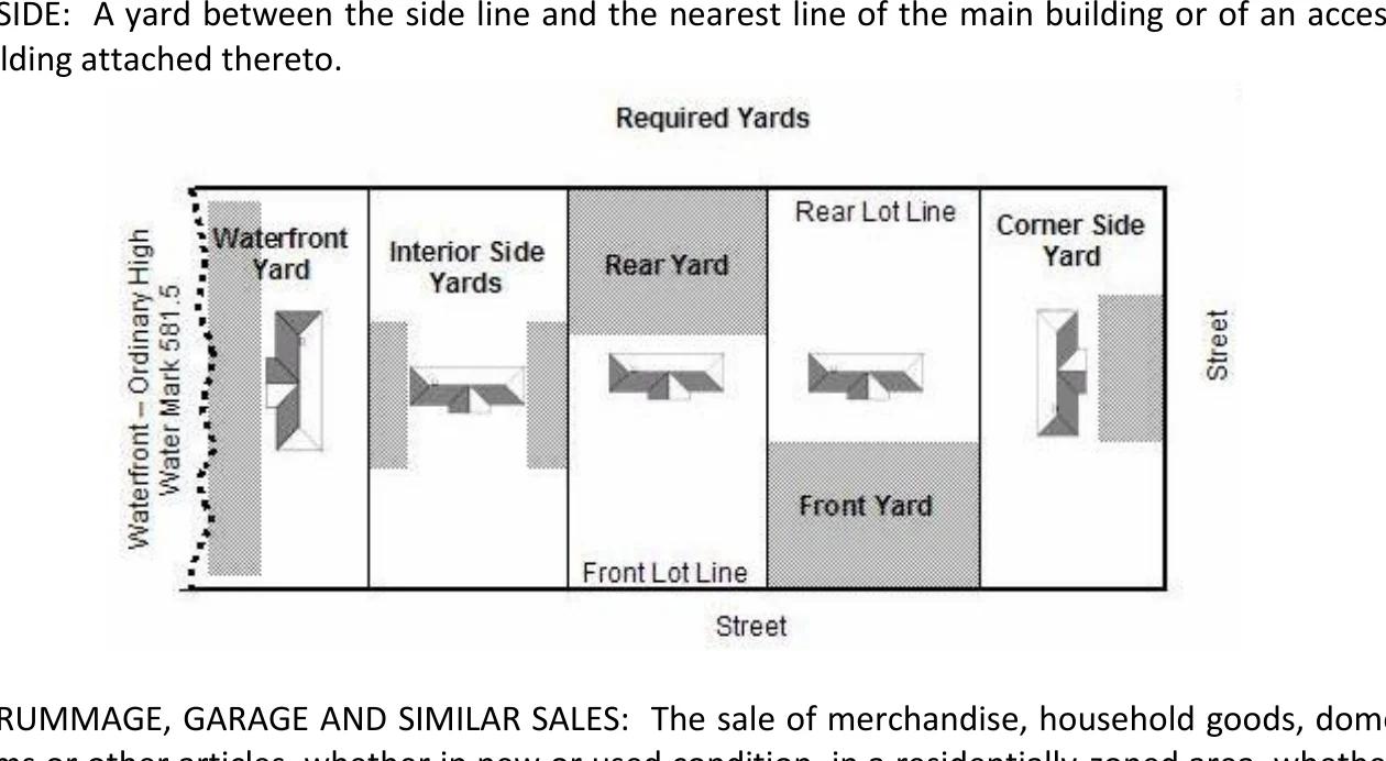 (opens the full-size diagram in a new tab)
Read a text description of this diagram
YARD, RUMMAGE, GARAGE AND SIMILAR SALES: The sale of merchandise, household goods, domestic items or other articles, whether in new or used condition, in a residentially-zoned area, whether for profit, barter or elsewhere on the property.
- a.The sale is temporary and shall not continue for a period to exceeding seven (7) days from date of commencement, and may not commence again for at least ninety (90) days from the last date of prior sale at the location with no more than three (3) such sales per year. No items available during sales may be openly displayed when sales are not in progress.
- b.The sale shall not be intended for more than incidental income and shall not be intended to operate as a commercial venture providing regular income.
Chapter 3 General Requirements
Section 3.1 Scope of Regulations
Any business or organization in violation of local, state or federal law is prohibited from operating or location within the Lincoln Township limits.
Section 3.2 Nonconforming Uses
It is the intent of this Ordinance to recognize that the eventual elimination, as expeditiously as is reasonable, of existing uses or structures that are not in conformity with the provisions of this Ordinance is as much a subject of health, safety, and welfare as is the prevention of the establishment of new uses that would violate the provisions of this Ordinance.
- a.NONCONFORMING STRUCTURES: Where a lawful nonconforming structure exists on the effective date of this Ordinance, such structure may be continued, subject to the following provisions.
- 1)No such structure may be enlarged or altered in a way which increases its nonconformance except those allowed in 3.2 (C) 4.
- 2)Should such structure or portion of structure be destroyed by any means to an amount of more than its State Equalized Value (SEV) at the time of destruction, it shall not be reconstructed in conformity with the provisions of this Ordinance.
- b.NONCONFORMING USE OF LAND. Where a lawful nonconforming use of land exists on the effective date of this Ordinance, such use may continue, provided:
- 1)No such use shall be enlarged or increased, nor extended to occupy a greater area of land that was occupied at the effective date of this Ordinance.
- 2)If any such use of land ceases for any reason for a period more than one hundred eighty consecutive days (180 days), such use shall not be reinstated, and said land shall be used for only conforming use permitted in the district so located.
- 3)No additional structure shall be erected in connection with such nonconforming use of land.
- 4)Nothing in this Ordinance shall prevent the reconstruction, repair or restoration and the continued use of any non-conforming building or structure damaged by force, explosion, acts of nature, acts of the public enemy, subsequent to date of this Ordinance, wherein expense of such reconstruction does not exceed ninety (90%) percent of the fair valuation of the building or structure at time such damage occurred, provided that such valuation be approved by the Board of Review of the Township and provided further that said use be identical with the non-conforming use permitted and in effect directly proceeding such damage.
- c.NONCONFORMING USE OF STRUCTURE: Where a lawful nonconforming use of a structure exists on the effective date of this Ordinance, such use may continue subject to the following provisions.
- 1)An existing structure devoted to a use not permitted in the district in which it is located shall not be enlarged, extended, reconstructed, moved, or structurally altered except in changing the use of the structure to a use permitted in the district in which it is located.
- 2)Any nonconforming use may be extended throughout any parts of a building which are arranged or designed for such use on the effective date of this Ordinance, but shall not be extended to occupy any land outside such building.
- 3)Any nonconforming use of a structure, or structure and premises, may be changed to another nonconforming use provided that the proposed use is equally appropriate or more appropriate to the district than the existing nonconforming use after approval of the Zoning Board of Appeals. Whenever a use has been changed to a use permitted in a district or greater restriction it shall not thereafter be changed to a nonconforming use.
- 4)A dwelling nonconforming due to its location in a non-permitted district, may be expanded or enlarged for residential purposes, by up to fifty (50%) percent of the existing ground floor area. An accessory building may be constructed or expanded upon the same lot.
- 5)When a nonconforming use of a structure is discontinued or abandoned (6) six months, the structure thereafter shall not be used for any use other than a conforming use of the district it is located within.
- d.REPAIRS AND MAINTENANCE: On any nonconforming structure or portion of a structure containing a nonconforming use, structural repairs and alteration may be made which do not add to the bulk of the structure or increase in intensity of the use of the structure. If a nonconforming structure or portion of a structure containing a nonconforming use become physically unsafe or unlawful due to lack of repairs and maintenance and is declared by the Building Inspector to be unsafe or unlawful by reason of physical condition, it shall not be restored, repaired or rebuilt except in which it is located.
Section 3.3 Supplementary Use Regulations
- a.PRIOR BUILDING PERMITS. Any building permit issued to the effective date of this Ordinance shall be valid, even though not conforming to the provisions of this Ordinance, provided that construction is commenced within ninety (90) days after the date the permit is issued and that the entire building shall be completed according to the plans filed with the permit application within one (1) year after the issuance of the building permit. All structures must have a building permit or temporary use permit. Temporary uses may exist no more than 90 days per year.
- b.ACCESS TO A ROAD. Any lot of record created after the effective date of this Ordinance shall have adequate frontage, as required in this ordinance, on a public street and be a legal lot, or as may otherwise be specifically approved by the Zoning Board of Appeals.
- c.COMMON DRIVEWAYS.
- 1)A single 66’ right of way may serve as ingress and egress for not more than two residences lacking sufficient frontage on a public road as required by this ordinance by administrative action of the zoning administrator.
- 2)Prior to issuing a zoning permit for construction of a structure whose source of access is off a common driveway, the Zoning Administrator shall find that:
- a)The owner of land upon which the common driveway is to be constructed, records with the Midland County Register of Deeds an easement granting rights of ingress and egress for the benefit of both residences serviced by the common drive.
- b)A written maintenance agreement signed by the owners of each lot or residence to be served by the common driveway shall be recorded with the Midland County Register of Deeds. The agreement shall allocate the responsibility to maintain the common driveway between or among the owners and shall be binding upon the successive owners of the lots or residences. It shall be the responsibility of the owners to enforce the terms of the agreement.
- c)A staked boundary survey showing the location of the driveway easement shall be filed with the site plan for a common driveway.
- d.ROADS, RIGHT-OF-WAYS AND EASEMENTS. All road right-of-ways and easements must meet the Midland County Road Commission standards.
- e.PRIVATE ROADS.
- 1)A private road is a road that provides direct access to a parcel and which is not dedicated to and accepted by an authorized governmental road agency. A common driveway as used in this ordinance does not constitute a private road.
- 2)Application, review, and approval of a proposed private road shall follow the same procedures as Special Land Use permits with regard to notice and timing.
- 3)Application for approval of a private road shall include a site plan sealed by a professional engineer showing the following:
- a)Existing and proposed lot lines.
- b)The location of existing and proposed structures.
- c)The width and location of the private road easement.
- d)A cross section of the proposed road, showing the types of materials, road base and surface of which the road will consist.
- e)Utility plans including the location and size/capacity of storm water drainage systems, sere or septic systems, water lines or private wells and private utilities such as telephone, electrical
and cable service and any other utility to be included within the easement (Including but not limited to has lines.)
- f)Proposed locations of driveways on private roads.
- g)Any existing or proposed structures, trees or other obstructions within the proposed right-of-way.
- h)All divisions of land shall be in compliance with the Land Division Act, Act 288, of 1967, as amended.
- i)Typical road cross-sections as identified within the Midland County Subdivision and Road Standards Guidebook.
- 4)The private road shall meet the following standards:
- a)The minimum right of way shall be sixty-six (66’) feet.
- b)The Subdivision Design and Road Construction Standards published by the Midland County Road Commission shall be the only standards accepted for private road construction within Lincoln Township
- c)A written maintenance agreement signed by the owners of each lot or residence to be served by the private road shall be recorded with the Midland County Register of Deeds. The agreement shall allocate the responsibility to maintain the private roadway between or among the owners, and shall be binding upon the successive owners of the lot or residences. It shall be the responsibility of the owners to enforce the terms of the agreement.
- f.REAR DWELLING PROHIBITED. No building in the rear of and on the same lot with a principal building shall be used for residential purposes except for watchmen, caretakers, and domestic employees whose employment functions are related to the function of the principal building; PROVIDED that all other requirements of this Ordinance are satisfied.
- g.USE OF STRUCTURE FOR TEMPORARY DWELLING. No structure shall be used for dwelling purposes that does not meet the minimum standards as defined in this Ordinance and the requirements of the Building Code. No temporary structure whether of a fixed or portable construction shall be erected for any length of time unless authorized by the issuance by the Zoning Board of Appeals of a temporary permit.
- h.ONE DWELLING PER LOT. Only one (1) single-family detached dwelling will be allowed to be erected on a lot in a single family district.
- i.FENCES AND WALLS. No fence, wall or structural screen, other than plant materials shall be erected on any residential property greater than six (6) feet in height nor shall any fence, wall or hedge planting exceed a height of three (3) feet within twenty-five (25) feet of the road edge. On a corner lot, no fence or planting shall be allowed that will interfere with traffic visibility across a corner. No fence, wall or structural screen in a residential area shall have barbed wire, electrified components or otherwise be intended to cause harm in preventing entry to property. Properties in excess of five (5)
acres and used for agricultural production or enclosure of farm or domesticated animals are excluded for this provision.
- j.SCREENING REQUIREMENTS.
- 1)Whenever screening is required between two zoning districts, there shall be provided at the time of development of any premises, and maintained thereafter, an “obscuring screen”, which shall be a fence, wall, plant materials, or other screening device, or combination thereof, that obstructs seventy-five (75%) percent of the field of vision from the ground to a height of six feet (6) when viewed from a distance of five feet (5) or more. Open spaces within such screening shall not exceed a one foot square (1), or exceed a two foot square (2) area when elongated or irregular shape. Such screen shall be constructed in accordance with one (1) or a combination of the following.
- a)A solid wall or fence with a finished surface fronting on residential district. All materials shall be new or other material if approved by the Building Inspector.
- b)A landscape buffer not less than fifteen feet (15) in width consisting of not less than seventy-five (75%) percent evergreen material. Plant material shall be of variety which shall maintain and “obscuring screen”.
- c)A buffer consisting of a combination of earthen berm, fencing, and/or plant materials which will provide an “obscuring screen”.
- d)All screening shall be a minimum of six feet (6) in height as measured from the highest ground elevation within three feet (3) on either side of the line separating the zoning districts.
- 2)The developer shall submit plans and specifications for the type of screening to be employed at the time application is made for a building permit.
- 3)The Zoning Board of Appeals may waive or modify these requirements where, in its opinion, the public interest would not be served by its strict application.
- 1)Whenever screening is required between two zoning districts, there shall be provided at the time of development of any premises, and maintained thereafter, an “obscuring screen”, which shall be a fence, wall, plant materials, or other screening device, or combination thereof, that obstructs seventy-five (75%) percent of the field of vision from the ground to a height of six feet (6) when viewed from a distance of five feet (5) or more. Open spaces within such screening shall not exceed a one foot square (1), or exceed a two foot square (2) area when elongated or irregular shape. Such screen shall be constructed in accordance with one (1) or a combination of the following.
- b.INOPERATIVE OR DISMANTLED CARS, TRUCKS OR BUSES. See Lincoln Township Ordinance #1 Junk Yards.
- c.TEMPORARY SALES.
- 1)The sale is temporary and shall not continue for a period to exceeding seven (7) days from date of commencement, and may not commence again for at least ninety (90) days from the last date of prior sale at the location with no more than three (3) such sales per year. No items available during sales may be openly displayed when sales are not in progress.
- 2)The sale shall not be intended for more than incidental income and shall not be intended to operate as a commercial venture providing regular income.
- 3)PARKING OR STORAGE OF RECREATIONAL VEHICLES, UTILITY TRAILERS AND EQUIPMENT. The parking of licensed and operable recreational equipment including travel trailers, campers, boats and similar recreational equipment, and utility trailers, is allowed within the following regulations:
- a)One recreational vehicle, equipment or utility trailer is permitted to park in the front yard, on an improved surface (paved or gravel), on a temporary basis which is not to exceed 90 days,
- b)Vehicles, equipment and trailers shall not be parked or stored closer than four feet (4) to any side or rear property line and
- c)Vehicles, equipment and trailers shall have adequate ingress or egress available or potentially available to either public or private right-of-way.
- d.HEAVY VEHICLES. Storage of trucks in excess of one & one-half (1.5) ton rated capacity is prohibited within a residential district.
- e.OUTDOOR WOOD FIRED HYDRONIC HEATERS.
- 1)Definitions
- a)"Clean wood'' means wood that has not been painted, stained, coated, preserved, or treated with chemicals such as copper chromium arsenate, creosote, or pentachlorophenol. The term does not include construction and demolition debris.
- b)"EPA'' means the United States Environmental Protection Agency.
- c)"Outdoor wood-fired hydronic heater'' (OWHH) or "outdoor wood boiler'' means a fuel burning device designed to burn wood or other solid fuels; That the manufacturer specifies for outdoor installation or in structures not normally occupied by humans, including structures such as garages and sheds; and Which heats building space and water through the distribution, typically through pipes, of a fluid heated in the device, typically water or a mixture of water and antifreeze.
- d)"Phase I OWHH'' means an OWHH that has been certified or qualified by the EPA as meeting a particulate matter emission limit of 0.6 pounds per million BTUs input and is labeled accordingly.
- e)"Phase II OWHH'' means an OWHH that has been certified or qualified by the EPA as meeting a particulate matter emission limit of 0.32 pounds per million BTUs output and is labeled accordingly.
- 2)Permit Requirements
- a)No OWHH may be installed or relocated from one lot to another lot in any district without first obtaining a permit from the building inspector. Any new installation or relocation of an OWHH must be inspected by the building inspector prior to use.
- b)Unit Requirements
- 1)Definitions
- (1)No person shall, from the effective date of this ordinance, operate an existing Outdoor Wood Furnace unless such operation conforms to the manufacturer’s instruction regarding such operation and the requirements of this ordinance regarding fuels that may be burned in an Outdoor Wood Furnace.
- (2)All new Outdoor Wood Furnaces shall be constructed, established, installed, operated and maintained in conformance with the manufacturer’s instructions and the requirements of this ordinance. In the event of a conflict, the requirements of this local law shall apply unless the manufacturer’s instructions are stricter, in which case the manufacturer’s instructions shall apply.
- (3)All new Outdoor Wood Furnaces shall be laboratory tested and listed to appropriate safety standards such as UL, CAN/CSA, ANSI or other applicable safety standards.
- (4)The owner of any new Outdoor Wood Furnace shall produce a copy of the manufacturer’s owner’s manual or installation instructions and a site plan of where the furnace will be located to the Code Enforcement/Building Department to review prior to installation.
- 3)Setback Requirements. The Outdoor Wood Furnace shall be located
- a)Behind the principal structure and at least 15 (fifteen) feet from the owner’s property line.
- b)At least 250 (two hundred and fifty) feet from any residence that is not served by the Outdoor Wood Furnace unless the owner of the neighboring property gives written permission and agrees to a deed notification for the property waiving the required setback.
- 4)Permitted Fuels. Permitted fuels means any fuel burned in an OWHH:
- a)Clean wood;
- b)Wood pellets made from clean wood;
- c)Home heating oil, natural gas, or propane that complies with all applicable sulfur limits and is used as a starter or supplemental fuel for dual-fired OWHHs.
- d)Corn
- 5)Prohibited Fuels. Prohibited fuels means any fuel burned in an OWHH other than permitted fuels. Prohibited fuel includes but is not limited to:
- a)Wood that does not meet the definition of clean wood,
- b)Garbage, refuse, tires, yard waste, materials containing plastic or rubber
- c)Newspaper, cardboard or any material with ink or dye products
- d)Petroleum products, including asphalt products, other than those that are permitted fuels,
- e)Paints and paint thinners, chemicals, coal,
- f)Plywood, particleboard, manure or other animal products or wastes.
- 6)Fuel Storage. Fuel must be stored behind the principal structure and in the rear or side yard and meet the setback for accessory structures.
- 7)Nuisance. A nuisance, is defined by this ordinance is “an offensive, annoying, unpleasant, or obnoxious thing, or practice, a cause or source of annoyance, especially a continual or repeated invasion of a use or activity which invades the property line of another so as to cause harm or discomfort, to the owner or resident of that property.”
- 8)If an existing Outdoor Wood Furnace is, through the course of a proper investigation by local authorities, creating a verifiable nuisance, the following steps may be taken by the owner and the (appropriate department) having jurisdiction:
- a)Cease and desist operating the unit until reasonable steps can be taken to ensure that the Outdoor Wood Furnace will not be a nuisance
- b)Modifications made to the unit to eliminate the nuisance such as extending the chimney/stack, or relocating the Outdoor Wood Furnace or both.
- f.GROUND WATER PROTECTION. All uses shall comply with following provisions.
- 1)Wastewater treatment systems, including on-site septic systems, shall be located to minimize any potential degradation of surface water or ground water quality.
- 2)Sites which include storage of hazardous materials of waste, fuels, oil, salt, fertilizers or chemicals shall be designed and constructed to prevent spills and discharges of polluting materials to the surface of ground water or nearby water bodies.
- g.FLOODPLAIN MANAGEMENT. No building, structure, or dwelling designed, constructed, intended, or used for human occupancy shall be moved on, constructed, erected, or occupied, in the one hundred (100) year floodplain of the Tittabawassee River and its tributaries.
- h.PONDS. Ponds less than one acre and constructed for recreational purposes only where all mined material is left on site, are exempt from the following regulations:
- 1)SCOPE OF REGULATIONS. This Section regulates extraction, filling or repositioning of soil, sand, gravel, clay or other geologic deposit involving disturbance of more than one thousand (1,000) cubic yards of material, when such disturbance is not related to construction of a building, structure, or parking lot. This Section also applies to artificial ponds created by soil excavation or intervention in watercourses, surface drainage or groundwater aquifers, regardless of size and whether the creation of the pond is an end in itself or merely a by-product of soil extraction activity. Ponds created by embankments or dams across streams or watercourses are not
permitted in Lincoln Township. Finally, oil wells are specifically exempted from this Section, because they are regulated solely by the Michigan Department of Natural Resources.
- 2)ADDITIONAL INFORMATION REQUIRED FOR SITE PLAN. The Site Plan for any activity regulated by this Section must include the following additional information.
- a)A profile of the proposed excavation, illustrating elevations and changes in slope, with elevations noted in five (5) foot intervals. If water is expected to accumulate in the excavation, the projected water level must also be shown.
- b)A soil evaluation report describing the excavation site and any needed drainage or seepage corrections.
- c)The specifications for any spillway or drain for a proposed pond, including the proposed methods of foundation preparation or fill placement.
- 3)EXCAVATION SITE REQUIREMENTS.
- a)Avoid sites of ecological significance, such as wetlands or mature forest. If wetlands are to be affected, a State permit may be needed.
- b)Excavations that create ponds should be located to minimize the chance of pollution from sources such as feedlots, corrals or septic tanks.
- c)Excavations may be no closer than fifty (50') feet, measured horizontally, to a power line, and may not be within a public utility or transportation easement.
- 4)CONSTRUCTION AND OPERATION REQUIREMENTS.
- a)An excavation should not change surface drainage or underwater aquifers so as to adversely impact neighboring uses.
- b)Any pond banks shall have a maximum slope of one (1') foot vertical to four (4') feet horizontal which extends below the projected low water surface elevation to a depth of at least eight (8') feet.
- c)Minimum designed water depth of a pond must be fifteen (15') feet to insure proper aeration and circulation of the water.
- d)All required environmental permits shall be obtained and obeyed, including the soil and sedimentation control permit under Act 451 of 1994.
- e)Any excavated material not removed from the site shall be graded to a continuous slope which does not exceed one (1') foot vertical to three (3') feet horizontal and arranged to prevent runoff from impacting adjacent properties. Said fill shall blend visually with the surrounding landscape. The completed portion of an excavation and any disturbed area around it, shall be graded, and seeded.
- f)No machinery or equipment shall operate, and no trucks, trailers, or other conveyances shall arrive at any excavation site before 7:00 a.m. or after 8:00 p.m.
- g)Proper measures shall be taken to minimize the nuisance of traffic noise and flying dust or soil while a site is being excavated.
- h)When two (2) or more Dwellings are located within two hundred feet (200') of the edge of any water body on an excavation site or on any parcel, said water body shall be enclosed by a fence at least four feet (4') high with a lockable gate.
- i)Ponds constructed for recreational purposes must be located behind the principle structure and inside the rear and side yard setbacks.
Section 3.4 Dwelling Regulations
- a.DWELLING UNIT STANDARDS. The following standards shall be applied to each dwelling unit constructed or placed in Lincoln Township:
- 1)It complies with the minimum square footage requirements of Chapter 3 for the district in which it is located.
- 2)It has a minimum width across any section of sixteen feet (16’) and complies in all respects with the Township building code, including minimum heights for habitable rooms. Where a dwelling is required by law to comply with any federal or state standards or regulations for construction, and where the standards of construction are less stringent than those imposed by the Township building code, then the more stringent Township regulations shall apply.
- 3)It is firmly attached to a permanent foundation, constructed on the site in accordance with the Township building code and co-extensive with the perimeter of the building, which attachment shall also meet all applicable building codes and other state and federal regulations.
- 4)It does not have exposed wheels, towing mechanism, undercarriage, or chassis.
- 5)The dwelling complies with all pertinent building and fire codes including, in the case of mobile homes, the standards for mobile home construction as contained in the United States Department of Housing and Urban Development (HUD) regulations entitled "Mobile Home construction and Safety Standards," effective June 15, 1976, as amended.
- 6)The foregoing standards shall not apply to a mobile home located in a licensed mobile home park except to the extent required by state or federal law or otherwise specifically required in the code of the Township pertaining to these parks.
- b.TEMPORARY MOBILE HOME. One (1) Mobile Home may be placed temporarily on a Parcel. The Mobile Home may house only the owner(s) of the parcel and immediate family members during the repair of a Single Family Home. The Temporary Permit shall be valid for up to six (6) months and may be issued by the Zoning Administrator under emergency conditions. The permit may be renewed not more than once for the same period by the Building Inspector.
- c.STRUCTURES TO BE OF UNIFORM QUALITY. Any additions, rooms or other areas of a dwelling must be constructed using workmanship and materials similar or higher in quality than the original structure. Such additions, rooms or other areas must be permanently attached to the principal structure and must be supported by a foundation.
- d.MAINTENANCE. A dwelling must be properly maintained and protected against deterioration and damage from the elements or the passage of time by prompt and appropriate repairs, surfacing, coating and any other necessary protective measures.
- e.ONE SINGLE FAMILY DWELLING PER PARCEL. Unless the structure is part of an approved Planned Unit Development, only one (1) single family detached dwelling will be allowed to be erected on a parcel.
Section 3.5 Home Occupation
Any business carried on by one or more members of family residing on the premises PROVIDED it:
- a.Be operated within the principal dwelling,
- b.Not more than one (1) employee not residing in the dwelling,
- c.All activities and storage shall be carried on indoors,
- d.Home occupations shall not be conducted in any accessory building or part thereof,
- e.Not use more than twenty-five (25%) percent of the total actual floor area of the dwelling.
Section 3.6 Supplementary Yard Regulations
- a.PERMITTED YARD ENCROACHMENTS.
- 1)Driveways shall not be subject to yard requirements.
- 2)Paved terraces, patios and uncovered porches excluding driveways shall not be subject to yard requirements provided:
- a)The area is unroofed and without walls or other forms of solid continuous enclosure that link the area to the principal dwelling. Such areas may have noncontiguous windbreaks or walls not over six feet (6) high and not enclosing more than one-half (1/2) the perimeter.
- b)No portion of any paved area is closer than five (5’) feet from any lot line nor projects into any front yard setback area.
- 3)Unenclosed covered or uncovered porches or decks, may project into a required side or rear yard area a distance not to exceed four feet (4’) provided:
- a)The porch is no higher than one (1) story and, is erected on supporting piers.
- b)The porch shall not be closer than five feet (5’) to any side or rear lot line.
- 4)Enclosed porches shall be considered an integral part of the building and shall be subject to all yard and area dimensional requirements established for principal buildings.
- 5)Signs may encroach into yard areas but no sign, or portion thereof, shall be closer to any lot line or street right-of-way than ten feet (10’).
- b.YARD EXCEPTIONS. In cases where less than the full required future right-of-way width of a street has been deeded or dedicated, the building setback on any property abutting thereon shall be measured from the future required sixty-six feet (66) of road right-of-way line. The required street width shall be determined by the standards set forth and adopted by the Midland County Road Commission.
Section 3.7 Supplementary Height Regulations
- a.PERMITTED EXCEPTIONS FOR STRUCTURAL APPURTENANCES. The following kinds of structural appurtenances shall be permitted to exceed the height limitations for authorized uses.
- 1)Institutional steeples, belfries, cupolas, domes, ornamental towers and flag poles; provided that such structural elements do not exceed twenty (20%) percent of the gross roof area.
- 2)Appurtenances for mechanical or structural functions, such as chimneys, smoke stacks, water tanks, elevator and stairwell penthouses, ventilators, radio or television towers, aerials, farm structures, windmills, and fire and base towers; provided the total height of the building and appurtenances is one hundred seventy-five feet (175’) or less from the ground. The foregoing permitted exceptions shall not be for human occupancy or dwelling.
- b.PERMITTED EXCEPTIONS: RESIDENTIAL DISTRICTS.
- 1)No exceptions are permitted for residential structures.
- 2)Principal hospital and religious structures may be permitted to exceed height limitations with a maximum total height limit of seventy-five feet (75’) provided each front, side and rear yard requirements is increased one foot (1’) for each additional one foot (1’) above the district requirement.
- c.PERMITTED EXCEPTION: BUSINESS AND INDUSTRIAL DISTRICTS.
In any business or industrial district, and principal building may erect to a height in excess of that specified for the district, provided each front, side and rear yard minimum is increased one foot (1’) for each additional one foot (1’) above the district requirement.
Section 3.8 Accessory Buildings
- a.REQUIRED YARDS.
- 1)IN A FRONT YARD. No accessory building shall project into any front yard.
- 2)IN A SIDE YARD. No accessory building, including detached garages, shall be erected closer to any side lot line than fifteen (15’) feet. (Amended November 27, 1999)
- 3)REAR YARD. No accessory building, including detached garages, shall be erected closer to rear lot line than permitted within the district for principal building. (Amended November 27, 1999)
- 4)ON A CORNER LOT. No accessory building shall be closer to the side street lot line than one-half (1/2) the front yard setbacks of the principal building on the lot. (Amended November 27, 1999)
- b.MAXIMUM SIZE. Accessory buildings may occupy not more than four (4%) percent of the lot area. Accessory structures greater than 100 square feet are not permitted on lots without a principal structure.
- c.HEIGHT. In a residential District, the height of an accessory building may not exceed sixteen feet (16’) maximum height for the sidewall as measured from the grade and may not exceed a total height of twenty-four feet (24’) to the peak. (Amended November 27, 1999)
- d.DWELLING. No portion of an accessory building in any zoning district is to be used as a dwelling.
- e.GARAGES.
- 1)Attached garages shall be considered part of the principal building for the purpose of computing required yards.
- 2)Attached garages may be located in front of, behind or on the side of principal structures and must be located outside of the required yard for principal structures.
- 3)Detached garages may be located behind or on the side of principal structures and may be located within the required side or rear yard but must comply with minimum setbacks for accessory structures. Detached garages may not occupy any part of the required front yard.
- f.OUTDOOR STORAGE CONTAINERS
When used for permanent storage in the R-1 or R-2 districts, outdoor storage containers must meet the following requirements:- 1)All outdoor storage containers must meet all applicable Michigan Building Code regulations.
- 2)No permanent electrical connection shall be provided to the container.
- 3)Outdoor storage containers shall be used only for the storage of personal goods and property associated with the dwelling, lot, or parcel on which the container is placed. The container shall not be used for the storage of commercial goods, business inventory, or personal property not associated with the property.
- 4)Outdoor storage containers are prohibited on a vacant lot or parcel.
- 5)Outdoor Storage Container shall not be stored on a lot smaller than 1 acre.
- 6)There shall not be more than two (2) outdoor storage containers located on a single parcel.
- 7)Outdoor storage containers may only be located in the rear and side yards according to Section 3.8 (a)(2) and 3.8(a)(3).
- 8)Outdoor storage containers shall not be stacked.
- 9)Outdoor storage containers shall be maintained, with no signage or logos, and each unit should be painted one solid color.
- g.The following graphic shows where the prohibited locations for detached accessory structures and sample of house and garage configurations.
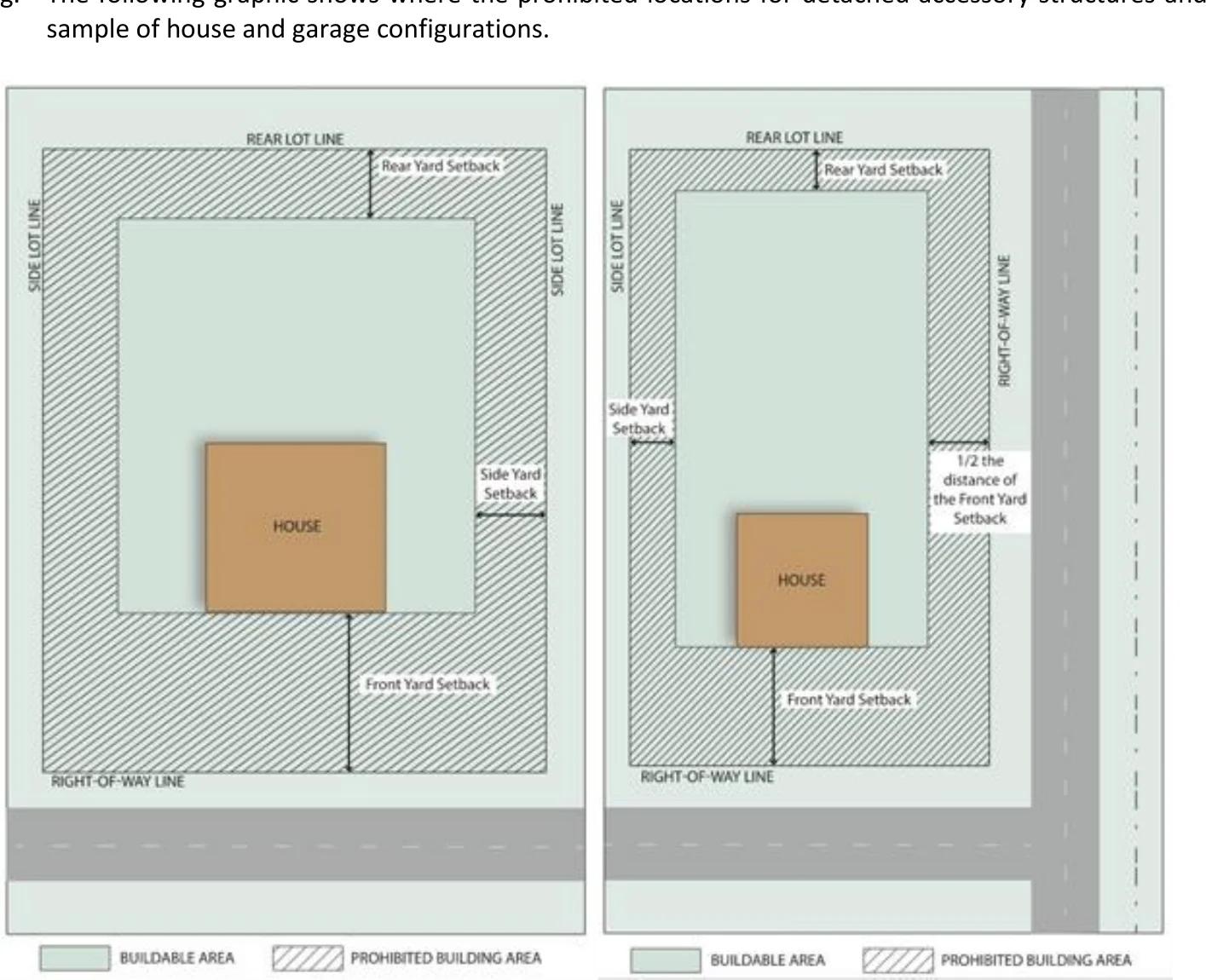 (opens the full-size diagram in a new tab)
Read a text description of this diagram
- h.USES: Nothing in this Ordinance shall be construed to prohibit the following accessory uses:
- 1)Customary refreshment and service uses and buildings in any public park or recreational area incidental to the recreational use of such area.
- 2)Essential services as defined in Chapter 2.
- 3)Garden, garden ornaments, yard improvements and usual landscape features within required yard space.
- 4)Fences within required yards provided the provisions of 3.3 (i) are met.
- 5)Retaining walls and public playgrounds.
- 6)Off-street parking for motor vehicles as specified in Chapter 4.
- 7)Home occupations.
- 8)Use of premises as a voting place in connection with local, state or national elections.
- 9)Freestanding individual wind turbines less than 65’ in height with a minimum lot size of 2 acres is required.
- 10)Storage sheds, playhouses, dog houses, detached garages and shelters for transit or school bus passengers.
- 11)Swimming pools – See applicable State laws.
- 12)Front yard handicap access facilities in residential districts with proof of need.
- 13)Roof Mounted On-Site Solar Energy Systems:
- a)Solar panels shall be permitted as a rooftop installation in any zoning district as an accessory use on a structure.
- b)The solar panels shall not exceed a height of 8” from the rooftop. In no event shall the placement of the solar panels results in a total height including building and panels than what is permitted in the zoning district which they are located for the principle building.
- c)The solar panels shall be placed so as not to produce any direct or indirect (reflective) lighting on a neighboring roadway, residence, or commercial area.
- 14)CARPORTS. Carports, must comply with the building code in effect and a permit must be obtained.
Section 3.9 Required Water Supply and Wastewater Disposal Facilities
No building or structure shall be constructed or used in whole or in part for dwelling, business, commercial or recreational purposes without sanitary sewer and connected toilet facilities inside the building or structure. These facilities must be connected to a sanitary sewer disposal system approved by the Midland County Health Department. The disposal system must not contaminate any body of water or water supply through its use. Only septic systems with tanks or municipal sewage disposal systems are allowed, except in municipal parks, municipal buildings and seasonal temporary uses when approved by the Zoning Administrator. Alternate methods of sewage disposal are not allowed, specifically lagoons systems.
Public waste water systems shall not be installed without sufficient capacity for, and optional use by, Lincoln Township residents.
All water supplies must be approved by the Midland County Health Department.
Adopted by the Township Board of Lincoln, County of Midland, Michigan on March 20, 2001.
Section 3.10 Animals and Fowl Other Than Household Pets
- a.It is prohibited to keep animals or fowl other than household pet in Residential or Business Districts unless, when adequately fenced, the parcel is at least five acres (5) in area; where the building housing the animal is at least two hundred and fifty (250’) from the nearest adjoining residence and the fence or corral is a minimum one hundred feet (100’) from the nearest adjoining residence.
- b.No wild or exotic animal shall be kept permanently or temporarily in any district in the Township except in an accredited American Association of Zoologies Parks and Aquariums facility.
Section 3.11 Dangerous and Abandoned Buildings
- a.UNLAWFUL CONDUCT
It is unlawful for any owner or owner's agent to keep or maintain any dwelling or structure or part of a dwelling or structure that is a dangerous building. - b.DEFINITION
As used herein, "dangerous building" means any building or structure that has any of the following defects or is in any of the following conditions:- 1)Whenever any portion of the building or structure has been damaged by fire, wind, flood, or by any other cause in such a manner that the structural strength or stability is appreciably less than it was before such catastrophe and is less than the minimum requirements of the Township Building Code for a new building or similar structure.
- 2)Whenever any portion has settled to such an extent that walls or other structural portions have materially less resistance to winds than is required in the case of new construction by the Township Building Code.
- 3)Whenever the building or structure or any part, has been structurally weakened because of dilapidation, deterioration, decay, faulty construction, or because of the removal or movement of some portion of the ground necessary for the purpose of supporting such building or portion of the building or structure.
- 4)Whenever for any reason whatsoever the building or structure or any portion is manifestly unsafe for the purpose for which it is used.
- 5)Whenever any dwelling becomes vacant, dilapidated and open at door or window, leaving the interior of the building exposed to the elements or accessible to entrance by trespassers.
- 6)An exposed basement or similar large hole that could present a danger is left on the site.
- c.NOTICE INFORMATION
- 1)Whenever the Township Building Inspector determines that the whole or any part of any building or structure is a dangerous building, the Township Code Enforcement Officer shall issue a notice of the dangerous and unsafe condition.
- 2)Such notice shall be directed to each owner or party in interest in the building in whose name the property appears on the last local tax assessment records.
- 3)All notices shall be in writing and shall be served upon the owner or party in interest directly and personally, or in lieu of personal service may be mailed by certified mail - return receipt requested and addressed to the owner or party in interest at the address shown on the tax records, at least ten (10) days before the date of the hearing described in the notice. A copy of the notice shall be posted upon a conspicuous part of the building or structure.
- 4)The Township Zoning Administrator shall file with the Planning Commission a copy of the notice of the dangerous and unsafe condition.
- 5)The notice shall specify the time and place of a hearing to be held before the Planning Commission on the condition of the building or structure, at which time and place the person or persons to whom the notice is directed shall have the opportunity to show cause why the building or structure should not be ordered to be demolished or otherwise made safe.
- d.HEARING INFORMATION
- 1)The Planning Commission shall take testimony from the Township Zoning Administrator, the owner of the property, and any interested party or other witness. The Planning Commission shall render its decision either closing the proceedings or ordering the building to be demolished or otherwise made safe.
- 2)If it is determined by the Planning Commission that the building or structure should be demolished or otherwise made safe, or basement or hole filled in and graded to the contour of the site, it shall so order, fixing a time in order for the owner or party in interest to comply.
- 3)If the owner or party in interest fails to appear or neglects or refuses to comply with the time limit of the citation of civil infraction, the Planning Commission shall file a report of its findings and a copy of its order with the Township Board and request that the necessary action be taken to demolish or otherwise make safe the building or structure. A copy of the findings and order of the Planning Commission shall be served on the owner or party in interest.
- 4)The Township Board shall fix a date for the hearing, reviewing the findings and order of the Planning Commission, and shall give notice to the owner or party in interest of the time and place of the hearing. At the hearing the owner or party in interest shall be given the opportunity to show cause why the building should not be demolished or otherwise made safe and the Township Board shall either approve, disapprove or modify the order for the demolition or the making safe of the building or structure.
- 5)The cost of the demolition or making the building safe shall be a lien against the real property and shall be reported to the assessing officer of the Township who shall assess the cost against the property on which the building or structure is located.
- 6)The owner or party in interest in whose name the property appears upon the last local tax assessment records shall be notified of the amount of such cost by first class mail at the address shown on the records. If the owner or party in interest fails to pay within thirty (30) days after mailing by the assessor of the notice of the amount due, the assessor shall add the cost to the next tax roll of the Township and the amount due shall be collected in the same manner as provided by law for the collection of taxes by the Township.
- e.JUDICIAL REVIEW
An owner or party in interest aggrieved by any final decision or order of the Township Board may appeal the decision or order to the circuit court by filing a petition for an order of superintending control within twenty (20) days from the date of the decision. - f.STATUTORY AUTHORITY
This section is promulgated pursuant to Act 61 of the Michigan Public Acts of 1969, MCLA 125.538 et seq. MSA 5.2891 et seq; and Act 359 of the Michigan Public Acts of 1947, MCLA 42.1 et seq. MSA 5.46(1) et seq.
Chapter 4 – General Off-Street Parking and Loading
Section 4.1 Purpose and Intent
It is the purpose and intent of the Ordinance that off street parking and loading areas be provided and adequately maintained in every zoning district for the purposes of promoting safe and efficient storage of motor vehicles; to avoid unnecessary congestion and interference with public use of streets; and to provide for sound and stable environmental conditions and the prevention of future blighted areas.
Section 4.2 Off Street Parking and Loading Requirements
- a.In all zoning districts, off street parking and loading requirements shall be provided in amounts not less than those specified for the various districts.
- b.Requirements for a use not mentioned shall be the same for that use which is most similar to the use not listed.
- c.Additional parking shall be provided and maintained in proper ratio to any increase in floor area or building use capacity.
- d.For the purposes of determining off street parking and loading requirements, the following provisions shall apply:
- 1)In business establishments, gross floor area shall mean the floor area used for service to the public. It shall not include floor area used for storage or the processing and packing of merchandise where it is carried on in a room in which service to the public is not involved.
- 2)In hospitals, bassinets shall not be counted as beds.
- 3)Where benches, pews or other similar seating facilities are used as seats, each twenty (20”) inches of such seating shall be counted as one (1) seat.
- e.In the case of mixed uses in the same building, the total requirements of off street parking and loading shall be the sum of the requirements for the individual uses.
- f.In case of a situation where there is more than one use in a single structure the following off-street parking regulations may apply:
- 1)For two (2) uses per structure, eighty (80%) percent of the otherwise combined required parking.
- 2)For three (3) uses, seventy-five (75%) percent.
- 3)For four (4) uses, seventy (70%) percent.
- 4)For five (5) or more, (65%) percent.
- 5)In no case shall less than sixty-five (65%) percent be allowed.
- g.It shall be unlawful to use any of the off street parking or loading area established to meet the requirements of this Ordinance for any purpose other than the parking of licensed vehicles of the loading or unloading or necessary service trucks or special events as approved by the Township Board.
- h.In commercial and industrial area, parking and loading setback areas shall conform to twenty foot (20’) front yard and street side requirements and off street parking shall be no closer to any principal building than five feet (5’). Bumper guards or curbs shall be installed to prevent yard encroachment.
- i.Parking and loading areas may be extended to the property line except as herein above specified by Section 4.2(h) and as specified under Section 4.3(c).
- j.SHARED ACCESS. The Planning Commission must require shared access between and among uses where feasible, excluding single family residential uses. Feasibility is determined with respect to the physical design of the site and not the effort or costs involved with achieving joint access. This requirement applies to driveways and access drives associated with site redevelopment or new construction. In the case of new development, a joint driveway agreement must be signed by all property owners involved prior to a construction permit being issued. Driveways must be designed to allow joint access in the future, where feasible, and an agreement to allow future use of the drive for joint access must be signed at the time of site plan approval. Shared drives must be shown on site plans at the time of review by the Planning Commission. Refusal to design a site with provisions for joint access or refusal to participate in a joint access agreement is justification for site plan denial by the Planning Commission.
- k.DRIVEWAY CLOSURE. Nonconforming driveways, per this ordinance, shall be made to be less nonconforming at the time a site is redeveloped. Lessening the degree of driveway nonconformance may include the Planning Commission requiring closing a driveway or combining driveways or access points at the time of site plan review.
- l.The OCCUPANCY of a building or any part of a building shall not change it from one use to a use in another classification unless the minimum parking requirements are provided for the new use. No building shall be enlarged if the enlargement requires additional parking space, unless the minimum requirements for off-street parking are provided.
- m.Parking spaces may COUNT TOWARD THE REQUIREMENT for a Parcel if they are located on it or on an adjoining Parcel where the farthest space is not over five hundred (500’) feet from the nearest public entrance to the Principal Building, with a continuous paved walkway between the lot and entrance.
Section 4.3 Site Development and Construction Requirements
The following off street parking and loading areas apply for all uses except one (1) and two (2) family dwellings:
- a.Shall be surfaces with a material that shall provide a durable, smooth and dustless surface; and shall be graded and provided with adequate drainage to dispose of all collected surface water; and, if surface with concrete or asphalt, shall conform to the following:
- 1)A minimum thickness of four (4”) inches of concrete or;
- 2)Two and one-half (2 ½”) inches of asphalt surface laid on a base of crushed stone with a compacted thickness of six (6”) inches.
- b.Shall have adequate ingress and egress to the parking areas by means of clearly marked and limited drives shall be provided:
- 1)Except for parking space provided one (1) family and two (2) family lots, drives for ingress and egress to parking areas shall be not less than twenty-two feet (22’) in width.
- 2)Each entrance to or exit from any off street parking area shall be at least twenty-five feet (25’) from any adjacent lot or parcel.
- c.Off street parking on lots adjoining or with a Residential District shall conform with the following requirements:
- 1)Noncommercial vehicles may be parked in any part of the required side or rear yard except as otherwise provided in this Ordinance.
- 2)Lighting used to illuminate any off street parking area shall be so located and arranged as to direct light away from the adjoining premises.
- 3)Where the required parking area of three (3) spaces or more is within forty feet (40’) of an adjoining Residential District or lot, said parking area shall be no closer to any side or rear property line than ten feet (10’) and within said ten foot (10’) strip, of the following shall be established.
- a)A planting strip five feet (5’) in width approved by the Building Inspector. Said planting strips shall not be less than five feet (5’) in height and shall consist of a sufficiently dense material to screen the parking and shall be adequately maintained.
- b)A solid masonry wall or uniformly treated wood fence not less than five feet (5’) in height.
- c)Said wall or planting strip shall be of such length as the width or length of the parking area.
- d)Off street parking areas shall be lighted when provided for all uses, except single-family and two-family duplexes, in accordance with a plan approved by the Planning Commission.
- e)Parking as specified and/or provided in any residential district shall not be allowed to encroach into the front yard.
Section 4.4 Off Street Parking Requirements
The minimum number of off street parking spaces by type of use shall be determined in accordance with the following schedule:
- a.Parking or storage of motor vehicles shall be provided for in all districts in connection with all industrial, commercial, business, trade, institutional, recreational, or dwelling uses and similar uses. In the case of a building, structure, or premises, the use of which is not specifically mentioned, the provisions for a use which is mentioned and to which the use in question is similar, shall apply. Handicapped parking shall be provided.
- b.In case of a situation where there is more than one use in a single structure the following off-street parking regulations may apply. The Planning Commission shall have the power to reduce parking further in the case of shared drives, shared parking or other circumstances where a reduction in parking will contribute to the safety, function or overall site design.
- 1)For two (2) uses per structure, eighty (80%) percent of the otherwise combined required parking.
- 2)For three (3) uses, seventy-five (75%) percent.
- 3)For four (4) uses, seventy (70%) percent.
- 4)For five (5) or more, (65%) percent.
- 5)In no case shall less than sixty-five (65%) percent be allowed.
- c.In cases where there is a single specified use, the following regulations shall apply:
- 1)Vehicle sales. One parking space per each one thousand (1,000) square feet of sales floor area.
- 2)Vehicle service garages. One parking space for each one thousand (1,000) square feet of building floor area.
- 3)Barber and beauty shops. One (1) parking spaces for each chair or booth.
- 4)Bowling alleys. One (1) parking spaces for each bowling lane. If in addition to alleys, patrons are provided with assembly halls, bars, restaurants, or other businesses, additional off-street parking spaces will be required in accordance with regulations of this section for the uses.
- 5)Places of public assembly. One (1) parking space for each four (4) seats.
- 6)Commercial recreation (outdoor). Twenty-five (25%) percent of lot area, but in no case less than ten (10) parking spaces.
- 7)Commercial recreational (indoor). One (1) parking space for each two hundred (200) square feet of building floor space.
- 8)Dance hall, roller rink, assembly hall. Without fixed seats, two hundred (200%) percent of the building floor area used for dancing or assembly.
- 9)Funeral homes. One (1) parking space per fifty (50) feet of building floor area of assembly rooms.
- 10)Furniture sales, retail. One (1) parking space for each one thousand (1,000) square feet of building floor area.
- 11)Gasoline service stations. One (1) parking space for each employee on the largest shift, plus one for each service bay.
- 12)Hospitals and convalescent homes. One (1) parking space for each hospital bed and one (1) parking space for each four (4) nursing home beds.
- 13)Laundromats. One (1) parking space for every three (3) washing machines or four hundred (400) square feet of gross building floor area, whichever is greater.
- 14)Motels, hotels, motor courts, tourists or lodging homes, trailer courts, and clubs. One parking space for each sleeping room. If, in addition to sleeping rooms, patrons are provided with assembly halls, bars, restaurants, retail shops or other businesses, additional off-street parking spaces shall be required for the other uses in accordance with the regulations of this section for those uses. Parking reductions may apply.
- 15)Office buildings, including banks, business, and professional offices. One (1) parking space for each four hundred (400) square feet of building floor area, but in no case less than five (5) spaces.
- 16)Restaurant, carry out, self-serve food market. 1 per 250 square feet of public floor space.
- 17)Restaurant, drive in. 1 per 100 square feet of public floor space.
- 18)Restaurants, taverns, bars, cocktail lounges, and similar eating establishments. One (1) parking space for each four (4) seats provided for patron use.
- 19)Retail sales and personal services (except self-service food markets or supermarkets). Parking area equivalent to one (1) space per three hundred (300) square feet of the public floor area, not to exceed 1 per one hundred (100) square feet of public floor area.
- 20)Theaters. One (1) parking space for each four (4) seats.
- 21)Warehouses, storage buildings, lumber and supply yards, wholesale sales. One (1) parking spaces for each employee. If retail sales exist, required parking spaces shall be determined by using retail floor space requirements for the building floor area used for retail in conjunction with the employee requirement.
Section 4.5 Permit
No parking lot shall be constructed or enlarged unless and until a permit therefore is issued.
Section 4.6 Loading Requirements
In all zoning districts, loading area shall be provided in amounts not less than therein specified.
Section 4.7 Lighting
- a.Parking area and other exterior on-site lighting fixtures shall not exceed a height of twelve feet (12’) when located within two hundred (200’) feet of a residential district, and further may not exceed a height of sixteen feet (16’), unless otherwise permitted by the site plan review. Exterior lighting shall be so arranged that it is deflected away from adjacent General Requirements.
- 1)Only nonglare lighting shall be permitted.
- 2)All outdoor lighting shall be shielded to focus the light downward onto the site and away from adjoining properties. The light source or “hotspot” shall not be directly visible from adjoining properties.
- 3)Lighting shall be shielded so that it does no cause glare or interfere with the vision of motorists. See illustration on page 47.
- 4)Light trespass from a property shall not exceed 1.0 foot candles at the property line, measured at 5’ from the ground.
- 5)To prevent sky glow, lighting shall be shielded or designed to prevent light to project above a 90 degree horizontal plane. See illustration on page 47.
- 6)Up lighting of buildings for aesthetic purposes shall be confined to the target surface.
- 7)Gas station canopies and similar structures shall have lighting fixtures that are completely shielded along the perimeter of the canopy. The maximum light level allowed under a canopy shall be 20’ candle, measured at 5’ above the surface.
- b.Intensity. In parking areas, the intensity shall average a minimum of 1.0 foot candle, measured at 5’ above the surface. In pedestrian areas, the light intensity shall average a minimum of 2.0 foot candles, measured at 5’ above the surface.
- c.Permitted Lighting Sources and Shielding Requirements. Outdoor lighting shall comply with the following use and shielding requirements:
TABLE 1 PERMITTED LIGHTING TYPES AND REQUIRED SHIELDING
| Lamp Type | Permitted Use | Shielding Requirements |
|---|---|---|
| High pressure sodium, metal halide (Filtered and enclosed luminaries only. Where color rendering is critical concern, metal halide lights should be used.) | Street lighting, parking and security areas, sports parks, tennis courts, residential and agricultural security lighting, signage, display and sports lighting | Full |
| Fluorescent (warm white and natural lamps preferred) | Residential lighting, internal sign lighting | Full |
| Wall Pack | Parking and security areas | Full |
| Incandescent greater than 100 watts | Sensor activated residential lighting | Full |
| Incandescent less than 100 watts | Porch lighting and other low wattage residential uses | None |
| Any light source less than 50 watts | Any | None |
| Glass tubes filled with neon, argon or krypton | Display advertising | None |
- d.Height. Except as noted below, lighting fixtures shall not exceed a height of 22’ measured from the ground level to the centerline of the light source. Fixtures should provide an overlapping pattern of light at a height of approximately 7’ above ground level. These are height standards in commercial and industrial districts, based on consideration of the following: the position and height of buildings, other structures and trees on the site, the potential off-site impact of the lighting, the character of the proposed use, and the character of surrounding land uses. In no case shall the lighting exceed the maximum building height in the district in which it is located. The Planning Commission may increase the lighting height standards during site plan review for situations that they deem appropriate to do so.
- e.Prohibited Lighting.
- 1)Outdoor building and landscaping lighting. Unshielded illumination of the exterior of a building or landscaping is prohibited except with incandescent fixtures of 100 watts or less.
- 2)Laser Source Light. The use of laser source light for any similar high intensity light for outdoor advertising when projected above the horizontal is prohibited.
- 3)Searchlights. The operation of searchlights for advertising purposes is prohibited between 10:00pm and sunrise the following morning.
- 4)Exceptions.
- 5)Fossil Fuel Light. Fossil fuel light produced directly or indirectly from the combustion of natural gas or other utility type fossil fuels (e.g. gas lamps) is exempt from the provisions of this Section.
- 6)Temporary Carnival or Civil Uses. Lighting for permitted circus, fair, carnival or civic uses is exempt from the provisions of this Section.
- 7)Construction and Emergency lighting. Lighting necessary for construction or emergencies is exempt from the provisions of this article provided that said lighting is temporary and is discontinued immediately upon completion of the construction work or abatement of the emergency.
Special Conditions. Additional exception may be permitted subject to site plan review and upon finding that unique or special conditions on the site warrant the exception.
Chapter 5 – Sign Regulations
Section 5.1 Intent and Purpose
The sign regulations as herein set forth are intended to control the size, location, character and other pertinent features of all exterior signs.
The purpose of this section is to regulate all exterior signs so as to protect health, and safety and to promote the public welfare.
Section 5.2 Temporary Signs
The following signs shall be permitted anywhere within the Township and shall conform with all yard requirements herein and all such signs ground mounted shall not exceed a height of four feet (4’) above ground level, and all freestanding signs shall not exceed a height of twenty-four feet (24’) above ground level, and permitted signs shall conform to the following cited requirements shall not be illuminated.
- a.CONSTRUCTION SIGNS which identify the architects, engineers, contractors and other individuals or firms involved with the construction, but not including any advertisement of any product, and signs announcing the character of the building enterprise of the purpose for which the building if intended, during the construction period, shall be limited to a maximum area of twenty square feet (20’) for each firm. The signs shall be confined to the site of the construction and shall be removed within fourteen (14) days of the completion of the project.
- b.REAL ESTATE signs advertising the sale, rental or lease of the premises or part of the premises on which the signs are displayed, up to a total area of twelve square feet (12). Such signs shall be removed within fourteen (14) days of the sale, rental or lease.
- c.POLITICAL CAMPAIGN signs announcing the candidates seeking public political office and other data pertinent thereto, up to an area of thirty-two square feet (32sf) for each premise. These signs shall be confined within private property and removed within fourteen (14) days after the election for which they were made.
- d.STREET BANNERS advertising a public entertainment or event, if specially approved in advance by the Township Board and only for locations designated by the Township Board during and for fourteen (14) days before and seven (7) days after the event
- e.SHOW WINDOW signs in a window display of merchandise when incorporated with such a display. They need not be related in content with the display.
Section 5.3 Exemptions
The following types of signs are exempted from all the provisions of this Ordinance, except for the following requirements.
- a.PUBLIC SIGNS. Traffic or other municipal Signs including, but not limited to, the following, legal notices, historic site designations, municipal facility directional Signs, street or traffic Signs, railroad crossing Signs, danger and other emergency Signs as may be approved by the Township Board or any Federal, State or County agency having jurisdiction over the matter of the Sign. Such Signs may be located in any zoning district. However, all Signs on governmental property on which a municipal building is located shall meet the commercial zoning district requirements state herein.
- b.INSTITUTIONAL. Signs for any public, charitable, educational or religious institution, located entirely within the premises of that institution, up to an area of twenty-four square feet (24sf). Such signs may be illuminated in accordance with the regulations contained hereinafter. If building mounted, these signs shall be flat wall signs and shall not project above the roof line. If ground mounted, the top shall be no more than four feet (4’) above ground level.
- c.INTEGRAL. Monumental citations, commemorative tablets and the like when carved into stone, concrete or similar material or made of bronze, aluminum or other permanent type construction and made an integral part of the structure.
- d.HISTORIC MARKERS.
- e.HOME OCCUPATION SIGNS. Home occupation signs may be mounted on the wall of the structure or on the ground outside of the right of way and cannot exceed six (6) square feet in area.
- f.PRIVATE TRAFFIC DIRECTION. Signs directing traffic movement onto a premise or within a premise, not exceeding three square feet (3sf) in area for each sign. Illumination of these signs shall be permitted in accordance with the section hereinafter included on illumination. Horizontal directional signs on and flush with paved areas are exempt from these standards.
- g.Address numbers, nameplates (including apartment units and office suites) identifying the occupant or address of a parcel of land.
- h.Signs painted on or permanently attached to legally licensed vehicles that are used upon the highways for transporting persons, goods or equipment.
- i.Community special event Signs approved by the Township Board.
- j.One Sign advertising parcels of land or building for rent, lease or sale, when located on land or building intended to be rented leased or sold, not exceeding six (6) square feet in area, four (4) feet in height in residential districts and twenty-four (24) square feet in area, six (6) feet in height in office, commercial and industrial districts.
- k.Flags up to 32 square feet and no more than 1 in number. Additional flags are permitted and count toward the total square footage of permitted Freestanding/Pole signage
- l.Signs commonly associated with any national, local or religious holiday; provided that such Signs shall be displayed for a period of not more than sixty (60) consecutive days, nor more than sixty (60) days in any one year.
- m.Political campaign Signs, not to exceed one sign per candidate or issue, and not to exceed six (6) square feet of area per Sign, shall be permitted on all occupied lots, regardless of zoning. Political campaign Signs may not be displayed more than ten (10) days after an election for which they are related.
- n.Garage sale Signs not exceeding five (5) square feet in area and not displayed in excess of three (3) days.
- o.One Sign identifying on site construction activity, during the time of construction, not exceeding twenty four (24) square feet in area. Such Signs shall not exceed eight (8’) feet in height.
- p.Painting, re-painting, cleaning, maintenance, repair, and change of Sign message or graphics shall not be considered erection or alteration of a Sign which requires issuance of a Permit, provided that no structural alterations or additions to the display area are made.
Section 5.4 Nonconforming Signs
- a.INTENT. This ordinance is intended to encourage the eventual elimination of signs that do not comply with the ordinance. The elimination of non-conforming signs is as much a subject of health, safety, and welfare as is the prohibition of new signs in violation of this ordinance. Therefore, this ordinance attempts to realize the removal of non-conforming signs and to avoid any unreasonable invasion of established property rights.
- b.CONTINUANCE. A Nonconforming Sign may be continued during the useful life of the Sign if it is maintained in good condition. It shall not, however, be replaced by another Nonconforming Sign. It may not be structurally altered so as to prolong the useful life of the Sign. It may not be reestablished after damage or destruction if the Township determines that the estimated cost of reconstruction exceeds fifty (50%) percent of the estimated replacement costs.
Section 5.5 Prohibited Signs
The following Signs are considered to be unsafe, dangerous, hazardous or an attractive nuisance, therefore these Signs shall not be permitted, erected or maintained in any zoning district.
- a.Any Sign or other advertising structure or display which conveys, suggests, indicates or otherwise implies by pictures, drawings, words, emblems, logos, or other communication methods including, but not limited to human genitalia, sexual acts, adult nude human bodies, obscene words, or obscene gestures.
- b.Contain or are in imitation of an official traffic sign or signal or contain the words: “stop”, “go slow”, “caution”, “danger”, “warning” or similar words.
- c.Any Sign for which a permit has not been issued and which is not a Permitted Sign is prohibited, excluding any existing legal Nonconforming Sign.
- d.Signs which incorporate in any manner any flashing or moving lights.
- e.Street Banners, Portable Signs pennants, spinners and streamers, and inflatable figures except as specifically permitted in accordance with this Ordinance.
- f.Any Sign which moves or has any moving or animated parts, or images, whether the movement is caused by any mechanical, electronic or electrical device or wind or otherwise, including swinging Signs and strings of flags or streamers, or cloth flags moved by natural wind, excluding Electronic Message Boards as defined by this ordinance.
- g.Any Sign or Sign structure which
- 1)is structurally unsafe, or
- 2)constitutes a hazard to the safety or health of person or property by reason of inadequate design, fabrication, mounting or maintenance or because it has been Abandoned or
- 3)is not kept in good repair, or
- 4)is capable of causing electrical shocks to persons that may come in contact with it.
- h.Any Sign which by reason of it size, location, content, coloring, intensity, or manner of illumination constitutes a traffic hazard or a detriment to traffic safety by obstruction of visibility of any traffic Sign or control device on any public street or road.
- i.Any Sign, except traffic or other municipal approved Signs, as permitted in this ordinance that is located in or projects into or over a public right of way or dedicated easement.
- j.Any Sign that exceeds the height limitation for structures in the zoning district in which it is located, or a wall Sign that extends beyond or above the structure to which such Sign is affixed except as may specifically be provided for in other provisions.
- k.Placards, posters, circulars, show bills, handbills, political Signs, cards, leaflets or other advertising matter, except as otherwise provided herein, shall not be posted, pasted, nailed, placed, printed, stamped or in any way attached to any fence, wall, post, tree, sidewalk, pavement, platform, pole, tower, curbstone or surface in or upon any public easement, right of way or any public or private property whatsoever. Provided, however, nothing herein shall prevent official notices of the Township, school districts, County, State, or Federal Government from being posted on any public property deemed necessary. All placards, posters, circulars, show bills, handbills, political Signs, cards, leaflets or other advertising matter posted, pasted, nailed, placed, printed, stamped on any right of way or public property may be removed and disposed of by the Lincoln Township Code Enforcement Officer without regard to other provisions of this ordinance.
- l.Display or parking a motor vehicle or trailer upon a lot or premises in a location visible from a public right of way, for the primary purpose of displaying a Sign attached to, painted on or placed on the
vehicle or trailer, with the exception of vehicles used regularly in the course of conducting the principle use located on the premises.
- m.Roof Signs.
- n.No portion of a privately-owned Sign, or its supporting structures, such as poles or cables, shall be placed on, or within the air space above, publicly owned property, a public right-of-way (such as a street or sidewalk), or a proposed public right-of-way.
- o.Signs which obstruct free use of a roadway, required door, window, fire escape or other required exit way. No Sign may obstruct the clear vision area.
Section 5.6 Illumination
- a.The light from any illuminated sign shall be so shaded, shielded or directed that the light intensity or brightness will not be objectionable to surrounding area.
- b.No sign shall have blinking, flashing or fluttering lights or other illumination devices such as changing light intensity, brightness or color. Beacon lights are not permitted.
- c.No colored lights shall be used at any location or in any manner so as to be confused with or construed as traffic control devices.
- d.Neither the direct, nor reflected light from primary light sources shall create a traffic hazard to operators of motor vehicles on public thoroughfares.
- e.No exposed reflective type bulbs and no strobe light or incandescent lamp which exceeds fifteen (15) watts shall be used on the exterior surface of any sign so as to expose the face of the bulb, light or lamp to any public street or adjacent property.
Section 5.7 Structural Requirements
All signs shall comply with the pertinent requirements of the building code and all other applicable ordinances.
Section 5.8 Permit
Prior to construction or establishment of any sign, a permit shall be obtained from the Building Inspector. A sign permit shall become null and void if the work for which the permit was issued has not been completed with a period of six (6) months after the date of the permit. The following operations shall not be considered as creating a sign and therefore shall not require a sign permit.
- a.REPLACING COPY. The changing of the advertising copy or message on an approved painted or printed sign or on a theater marquee and similar approved signs which are specifically designed for the use of replaceable copy.
- b.MAINTENANCE. Painting, repainting, cleaning and other normal maintenance and repair of a sign or sign structure unless a structural change is made.
- c.TEMPORARY SIGNS, per Section 504 and signs under Exception, Section 505, including subheadings (1) through (7) , of this code are also exempt from permit requirements.
Section 5.9 Inspection, Removal, Safety
- a.INSPECTION. Signs for which a permit is required may be inspected periodically by the Building Inspector for compliance with this and other codes of the municipality.
- b.TAGGING. All signs requiring permits shall display, in a place conspicuous to inspectors, the name of the owner or erector as the inspector may designate.
- c.MAINTENANCE. All signs and components thereof shall be kept in good repair and in safe, neat, clean and attractive condition.
- d.REMOVAL OF SIGN. The Building Inspector may order the removal of any sign erected or maintained in violation of this code. He shall give thirty (30) days notice in writing to the owner of such sign, or of the building, structure or premises on which such sign is located, to remove the sign or to bring it into compliance. The Building Inspector may remove a sign immediately and without notice if, in his opinion, the condition of the sign is such as to present an immediate threat to the safety of the public.
- e.ABANDONED SIGNS. A sign shall be removed by the owner or lessee of the premises upon which the sign is located when the business which it advertises is no longer conducted on the premises. If the owner or lessee fails to remove it, the Building Inspector shall give the owner fifteen (15) days notice to remove it. Upon failure to comply with this notice, the Building Inspector or his duly authorized representative may remove the sign at cost to the owner. When a successor to defunct business agrees to maintain the signs as provided in this code, this removal requirement shall not apply.
| DISTRICT | TYPE | # PER PARCEL | MAX. SQ. FT. | HEIGHT | PLACEMENT |
|---|---|---|---|---|---|
| Residential R-1, R-2 | Wall | ||||
| Residential R-1, R-2 | Wall: Residential | 1 | 6 | N.A. | Anywhere on the structure wall |
| Residential R-1, R-2 | Wall: Nonresidential | 1 | 32 | N.A. | Anywhere on the structure wall |
| Residential R-1, R-2 | Wall: Nonresidential — If > 400 ft lineal road frontage, or on corner lot | 2 | 32 | N.A. | Anywhere on the structure wall |
| Residential R-1, R-2 | Wall: Multiple family | 1 | 32 | N.A. | Anywhere on the structure wall |
| Residential R-1, R-2 | Entrance Sign | 2 | 24, must be same size | 5’ | Street entrance |
| Residential R-1, R-2 | Monument – nonresidential¹ | 1 | 32 | 5’ | On property |
| Residential R-1, R-2 | Portable/Temporary² | 1 | 32 | 5’ | On property |
| Office Business B-1 | Freestanding/Monument³ | ||||
| Office Business B-1 | Freestanding/Monument³: < 400 lineal feet of frontage | 1 | 80 | 10’ | On property and 2’ outside road right-of-way |
| Office Business B-1 | Freestanding/Monument³: > 400 lineal ft of frontage and less than 20 acres | 2 | 80 per sign | 10’ | At least 100’ away from any other sign on parcel, and 25’ from side lot line. |
| Office Business B-1 | Wall/Marquee³˒ ⁴ OR Awning/Canopy³˒ ⁵ | 1 | 32 | N.A. | Anywhere on the structure wall |
| Office Business B-1 | Portable/Temporary² | 1 | 32 | 5’ | On property and 2’ outside road right-of-way |
| Office Business B-1 | Street banners⁶ | 1 | N.A. | N.A. | Over road |
| Business B-2 | Freestanding/Monument | ||||
| Business B-2 | Freestanding/Monument: < 400 lineal ft of frontage | 1 | 80 | 10’ | On property and 2’ outside road right-of-way |
| Business B-2 | Freestanding/Monument: > 400 lineal ft of frontage | 2 | 80 per sign | 10’ | At least 200’ from any sign on same parcel |
| Business B-2 | Freestanding/Monument: Additional signage permitted for a Multitenant Plaza | 0 | +16 | 10’ | Lettering on this portion of the sign must be at least 12” high |
| DISTRICT | TYPE | # PER PARCEL | MAX. SQ. FT. | HEIGHT | PLACEMENT |
|---|---|---|---|---|---|
| Business B-2 continued | Regional Commercial Center | ||||
| Business B-2 continued | Regional Commercial Center: Monument/Ground | 80⁷ | 12’ | On property and 2’ outside road right-of-way | |
| Business B-2 continued | Wall/Marquee⁴ OR Awning/Canopy⁵ | 1 | N.A. | N.A. | Anywhere on the structure wall |
| Business B-2 continued | Portable/Temporary² | 1 | 50 | 5’ | On property |
| Business B-2 continued | Special Event Signs | 1 | 50 | 16’ or 20’ in diameter | 15 days in any calendar year |
| Business B-2 continued | Street banners⁶ | 1 | N.A. | N.A. | Over road |
| Industrial M-1, M-2 | Wall/Marquee⁴ OR Awning/Canopy | 1 | N.A. | N.A. | Anywhere on the structure wall |
| Industrial M-1, M-2 | Freestanding/Monument < 400 lineal ft of frontage | 1 | 80 | 10’ | On property and 2’ outside road right-of-way |
| Industrial M-1, M-2 | Freestanding/Monument > 400 lineal ft of frontage and < 20 acres | 2 | 80 | 10’ | At least 100’ away from any other sign on parcel, and 25’ from side lot line |
| Industrial M-1, M-2 | Industrial Center Signs | 2 per public road frontage | 80 | 12’ | On property and 2’ outside road right-of-way |
| Industrial M-1, M-2 | Monument/Ground Mounted | 2,1 per entrance | 24 | 5’ | More than 100’ from entrance |
| Industrial M-1, M-2 | Portable/Temporary² | 1 | 32 | 5’ | On property and 2’ outside road right-of-way |
- 1Corner Lots: Two signs are permitted. If only 1 sign is used on a corner lot, each sign face may be 40 sq ft.
- 2Portable/Temporary: Placement may not exceed 45-days in any calendar year.
- 3Electronic message boards shall be subject to the same size, height and placement restrictions as the classification of sign they fall under, such as Wall/Marquee/Awning/Canopy Sign or Freestanding/Monument Sign. One flag is permitted on each parcel. Additional flags will be counted toward the permitted square footage for a Freestanding/Pole sign.
- 4May not project more than 12” from the building surface.
- 5May not project more than 7 ft from building surface, nor less than 9 ft above walking surface; may not extend more than 24” above roof line. There is no limitation on the square footage of a canopy sign.
- 6Street banners may extend across a public right of way subject to approval of Lincoln Township administration and the Midland County Road Commission or MDOT, but in no case may be displayed for more than 14 days before an event and 7 days after.
- 7Regional Commercial Centers are permitted an additional 30 sq. ft. of signage divided equally among each tenant for their use and displayed with the primary Monument/Ground Sign.
Chapter 6 Land Use Districts
Section 6.1 Division of the Township
For the purpose of this Ordinance, the Township of Lincoln is divided into the following Zone Districts:
| R-1 | Single Family Low Density |
| R-2 | Single Family Medium Density |
| B-1 | Business |
| B-2 | Business |
| M-1 | Light Industrial |
| M-2 | Heavy Industrial |
Section 6.2 Official Zoning Map
The boundaries of said zoning districts are hereby established as shown on the Zoning Map of Lincoln Township, which accompanies this Ordinance, and which map, with all notations, reference and other information shown thereon, shall be as much a part of this Ordinance as if fully described herein. The Zoning Map shall be maintained and kept up to date at the Township Hall, accessible to the public, and shall be final authority as to the current zoning status of lands, buildings, and other structures in the Township.
Section 6.3 Interpretation of Boundaries
- a.Boundaries indicated as approximately following the streets or highways or the center line of said roadways shall be construed to be such boundaries.
- b.Boundaries indicated as approximately following Township Boundary lines or following lot lines shall be construed as following said lines.
- c.Boundaries indicated as approximately parallel to the center lines of streets or highways shall be construed as being parallel to and at such distance from as indicated by given distance or scaled dimension.
Section 6.4 Scope of Regulations
No building or structure, or part hereof, shall hereafter be erected, moved, constructed, altered or used and no use of any lot or parcel within the Township of Lincoln shall be made unless it conforms with the provisions of the Ordinance and with the regulations specified for the district in which it is located.
The regulations applying to such districts include specific limitations on the use of land and structure, height and bulk of structures, density of population, lot area, yard dimensions and area of lot that can be covered by each structure.
Uses not expressly permitted are prohibited. Any business, organization, enterprise or use in violation of local, state or federal law is prohibited and is a violation of this Ordinance.
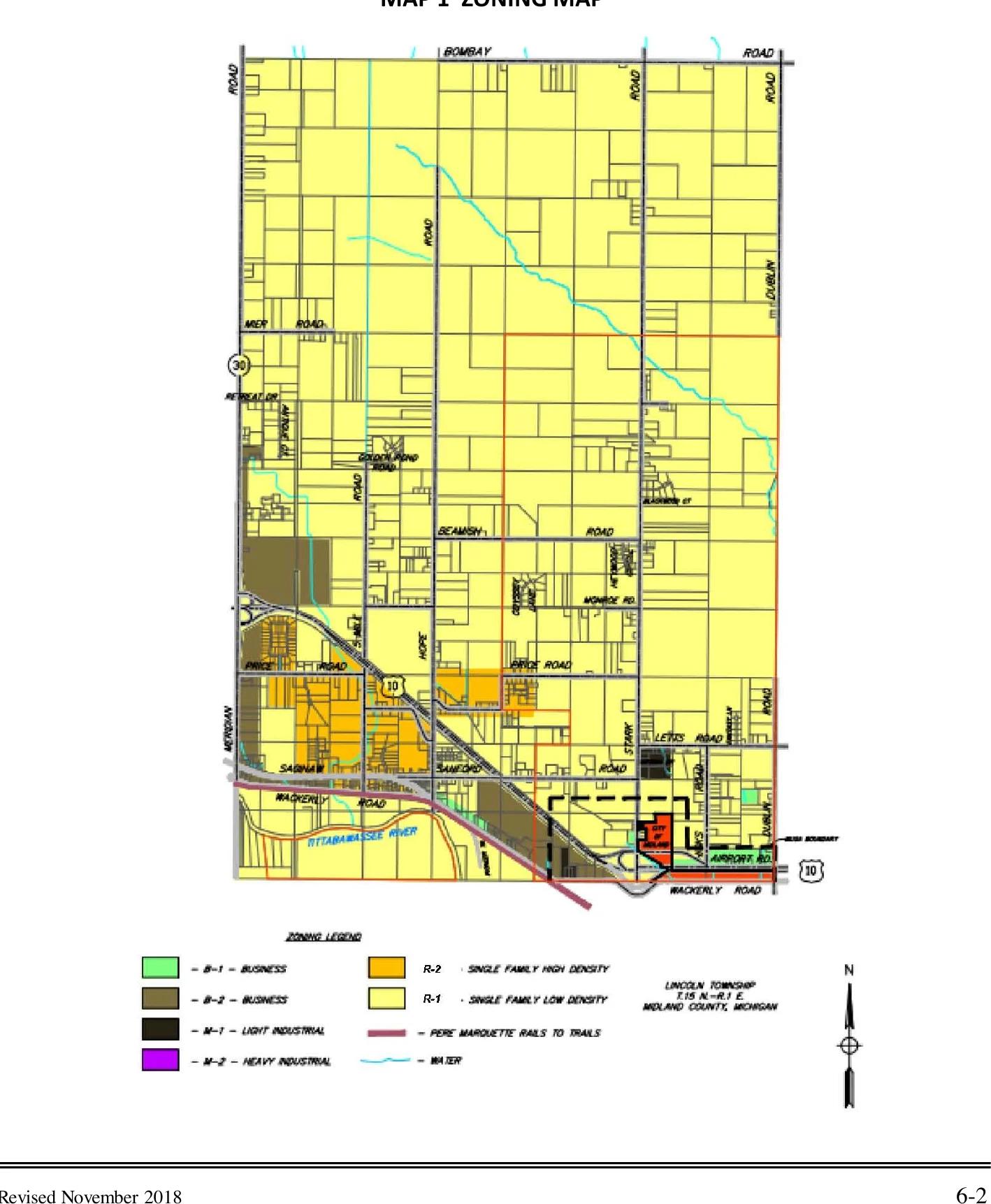 (opens the full-size map in a new tab)
Read a text description of this map
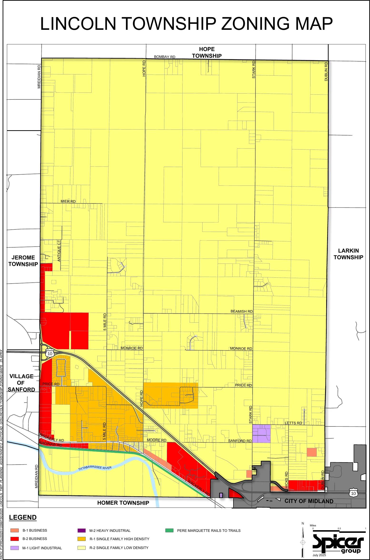 (opens the full-size map in a new tab)
Read a text description of this map
| ZONING DISTRICT | STATED INTENT AND PURPOSE |
|---|---|
| Residential R-1 Low Density | Provides a settling for single family residential uses, together with such related uses as schools, churches and recreational uses. The regulations are designed to encourage a residential environment of compatible low density dwellings on individual lots. |
| Residential R-2 Medium Density Residential | Provides for a medium density residential environment of a high quality. The district is further intended to provide for flexible and creative varieties of single-family development and for two, three and four family residential structures. |
| Business B-1 | This district accommodates office uses, office sales uses, business services and certain personal services. The district is intended as a transition area between residential area and more intensive business development and is intended principally for day-time business functions. |
| Business B-2 | Provides essential service needs to the highway traveler and to accommodate businesses serving a regional market. |
| Industrial M-1 | Is intended primarily for light manufacturing uses which possess few, if any, nuisance characteristics pertaining to the potential for explosion, radioactivity, smoke, dust, noxious or harmful wastes that would pollute streams or soil, vibration, noise, or odor. This District also contemplates uses of land that are not within the scope of uses permitted in the commercial and residential district but are not detrimental to the public health, safety, or welfare in connection with the uses for which such districts are established. All businesses in the M-l District must meet the Hazard and Nuisance Prevention Requirements of this Ordinance. |
| Industrial M-2 | This district establishes and preserves areas for industrial and related uses of a nature so that they do not create serious problems of compatibility with other kinds of land uses. This district is intended to make provisions for medium to heavy industrial uses and for certain kinds of business uses which are most appropriately located as neighbors of industrial uses or which are necessary to service the immediate needs of the businesses in these areas. All businesses in the M-2 District must meet the Hazard and Nuisance Prevention Requirements. |
| ZONING DISTRICT (R = Use by RIGHT, S = Use by SPECIAL USE PERMIT) | R-1 | R-2 | B-1 | B-2 | M-1 | M-2 |
|---|---|---|---|---|---|---|
| Accessory uses | R | R | R | R | R | R |
| Automobile Repair | R | R | R | |||
| Body shops | R | R | ||||
| Car wash | S | |||||
| Cemeteries | S | R | R | |||
| Clubs, halls | S | |||||
| Commercial cleaning plants | S | |||||
| Commercial recreation facilities | S | |||||
| Commercial schools | R | R | R | R | ||
| Consumer retail and service outlets | R | |||||
| Contractor storage yards | R | R | ||||
| Day nurseries | S | R | R | |||
| Farming: general | R | |||||
| Fireworks storage | R | R | ||||
| Fuel sales | R | R | ||||
| Funeral homes | S | R | R | |||
| Gas stations | R | R | R | |||
| Golf courses and Country Clubs, public and private areas | S | S | ||||
| Greenhouses | R | |||||
| Home occupations | R | R | ||||
| Industrial parks | S | S | ||||
| Institutions: Educational | S | S | ||||
| Institutions: Human care | S | S | ||||
| Institutions: Religious | S | S | R | R | ||
| Institutions: Rehabilitation | S | |||||
| Institutions: Social | S | S | ||||
| Institutions: Substance Abuse | S |
| ZONING DISTRICT (R = Use by RIGHT, S = Use by SPECIAL USE PERMIT) | R-1 | R-2 | B-1 | B-2 | M-1 | M-2 |
|---|---|---|---|---|---|---|
| Kennels | R | |||||
| Laboratories | R | R | ||||
| Lumber , hardware, plumbing, heating, electrical sales | R | |||||
| Manufactured housing parks | S | |||||
| Manufacturing | R | R | ||||
| Motels/hotels | S | |||||
| Multiple-family dwellings | S | R | R | |||
| Nurseries | R | |||||
| Open air businesses | R | |||||
| Outdoor uses | R | R | ||||
| Park, public, recreational | R | |||||
| Planned unit developments | S | S | S | S | ||
| Personal service establishments | R | R | ||||
| Production, processing, assembling, treatment or packaging of goods | R | R | ||||
| Professional offices | R | R | ||||
| Public buildings | S | R | R | |||
| Public service/utility installations | S | S | S | S | R | R |
| Restaurants, Bars and Taverns | S | R | ||||
| Resource extraction | S | S | S | |||
| Retail food establishments | R | R | ||||
| Salvage yard and resource recovery facilities | S | |||||
| Self-storage/mini-storage | R | R | R | |||
| Sewage treatment and disposal | S | |||||
| Sexually oriented businesses, Adult media stores | S | |||||
| Single-family dwelling | R | R |
| ZONING DISTRICT (R = Use by RIGHT, S = Use by SPECIAL USE PERMIT) | R-1 | R-2 | B-1 | B-2 | M-1 | M-2 |
|---|---|---|---|---|---|---|
| Small printing and reproduction centers | R | |||||
| Social buildings | R | R | ||||
| Solar Energy Facilities | S | S | S | S | S | |
| State licensed residential facilities for 6 or fewer residents | R | |||||
| State licensed residential facilities for 7-20 residents | S | |||||
| Storage of waste disposal vehicles | S | |||||
| Temporary outdoor uses | S | R | ||||
| Towing | R | R | ||||
| Truck terminals | R | R | ||||
| Two-family dwellings | R | R | R | |||
| Vehicle and machine repair, trailers, boats | R | R | R | |||
| Vehicle Sales, new and used; leasing | R | |||||
| Veterinary hospitals | R | |||||
| Warehouse and storage | R | R | ||||
| Wholesale and distributing | R | R | ||||
| Wireless communication facilities | S | S |
| ZONING DISTRICT | R-1 | R-2 | B-1 | B-2 | M-1 | M-2 |
|---|---|---|---|---|---|---|
| Lot Area, Min. sq. ft. | 1 acre | 1 acre | None | None | 25,000 sq ft | 25,000 sq ft |
| Lot Width, Min. | 132 ft; Corner lot 165 ft frontage | 132 ft; Corner lot 165 ft frontage | None | None | 125 ft | 125 ft |
| Front Yard, Min. | 50 ft | 50ft. | 60 ft | 60 ft | 60 ft | 60 ft |
| Back Yard, Min. | 25 ft | 25ft. | None | 25 ft; 100 ft abutting R-1 or R-2 | 100 ft abutting R-1 or R-2 | 100 ft abutting R-1 or R-2 |
| Side Yard | 25 ft | 25ft. | 25 ft; 100 ft abutting R-1 or R-2 | 25 ft; 100 ft abutting R-1 or R-2 | None | None |
| Housing Unit., Min. sq. ft. | 900 sq ft; 600 sq ft on ground floor for multi-story | 900 sq ft; 600 sq ft on ground floor for multi-story | N.A. | N.A. | N.A. | N.A. |
| Housing Unit, Min. dim. | 16’ | 16’ | NA | NA | NA | NA |
| Height, Max. Feet | 2 ½ stories or 35 ft | 2 ½ stories or 35 ft | 2 ½ stories or 35 ft | 2 ½ stories or 35 ft | 3 ½ stories or 45 ft | 3 ½ stories or 45 ft |
| Coverage, Max. Percent | 35% | 35% | 50% | 50% | 50% | 75% |
| Permitted Uses | Special Land Uses |
|---|---|
| Accessory Uses | Cemeteries |
| General Farming | Institutions: Human care, Religious, Educational, Social |
| Home Occupations | Planned Unit Developments |
| Single Family | Public and private golf courses, country clubs, parks |
| Public Utility transformer stations | |
| Resource Extraction | |
| Solar Energy Facilities |
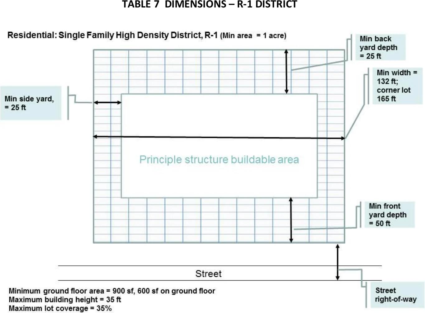 (opens the full-size diagram in a new tab)
Read a text description of this diagram
| Permitted Uses | Special Land Uses |
|---|---|
| Accessory Uses | All uses permitted by SUP in R-1 |
| Home Occupations | Day nurseries |
| Public Parks, Public Recreation | Funeral Homes |
| Single Family | Institutions: Rehabilitation, Substance Abuse |
| State Licensed Residential Facilities for fewer than 7 | Multiple Family dwellings |
| Two-Family | Public Buildings, Public Service Installations |
| State Licensed Residential Facilities for 7-20 |
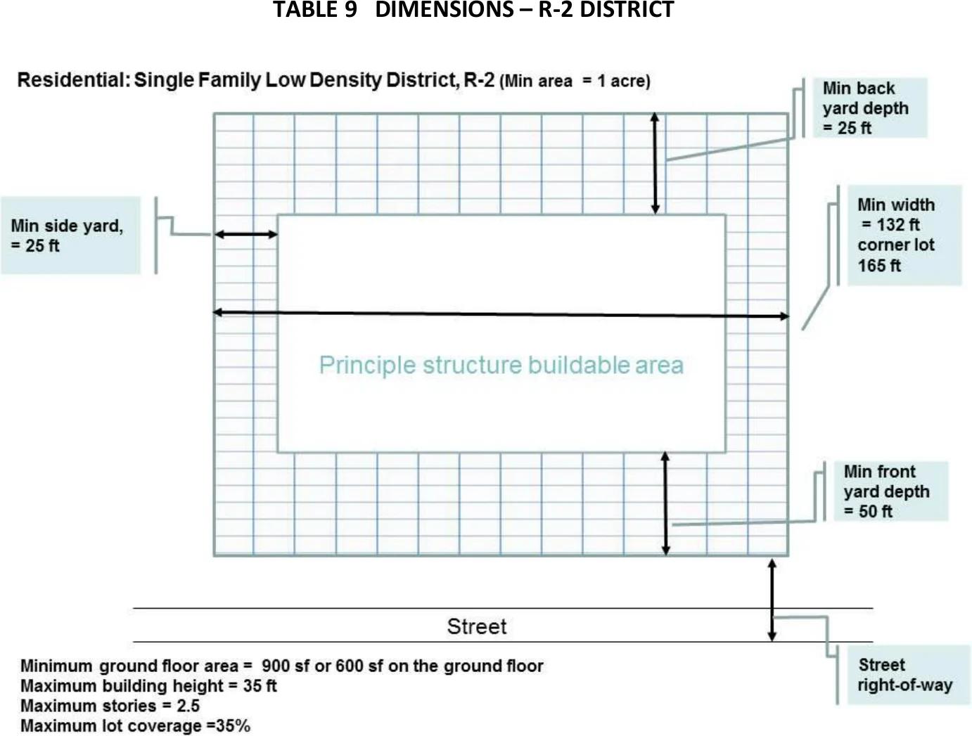 (opens the full-size diagram in a new tab)
Read a text description of this diagram
| Permitted Uses | Special Land Uses |
|---|---|
| Cemetery | Planned Unit Developments |
| Commercial schools | Public utility transformer stations, substations, gas regulator stations, utility control functions |
| Day Nurseries | Restaurants and Dining Establishments |
| Funeral Homes | Temporary Outdoor Uses |
| Institutions: Religious | Solar Energy Facilities |
| Multiple-Family Dwellings | |
| Personal Service Establishments | |
| Professional offices | |
| Publicly owned buildings, exchanges, public utility offices | |
| Retail Food Establishments | |
| Social and Public Buildings | |
| Two family dwellings |
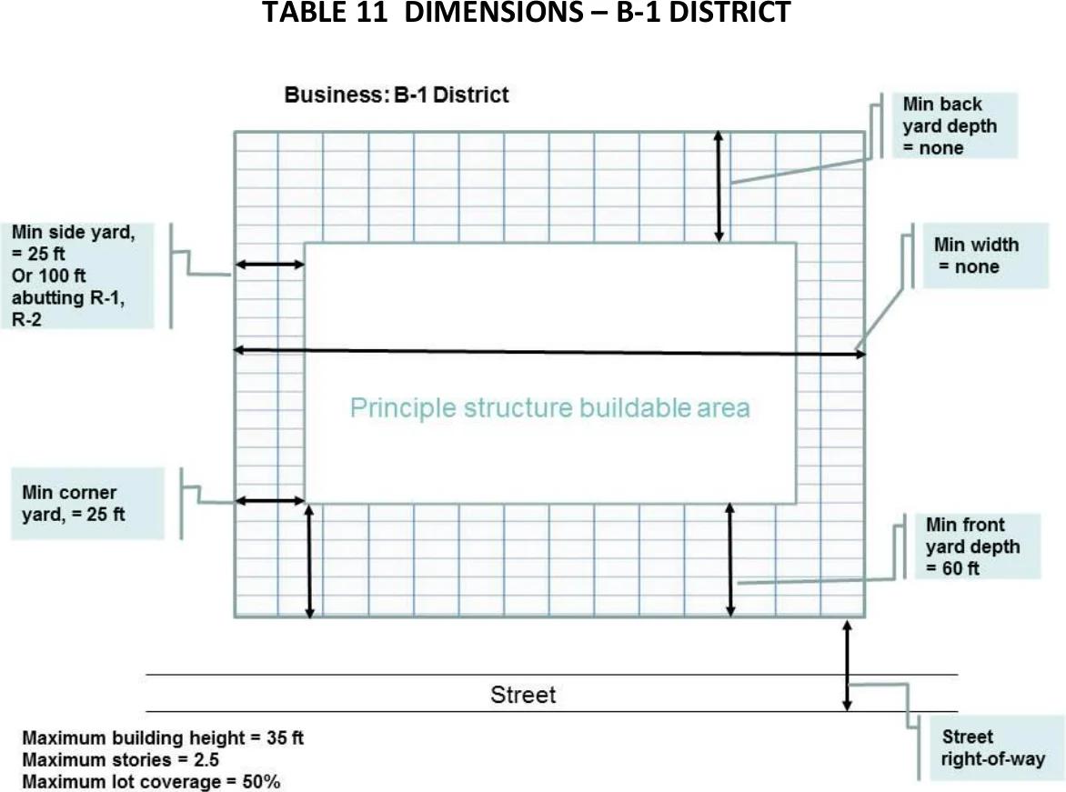 (opens the full-size diagram in a new tab)
Read a text description of this diagram
| Permitted Uses | Special Land Uses |
|---|---|
| All uses permitted by right in B-1 | All uses permitted by SUP in B-1 |
| Consumer retail and service outlets | Automobile Car Wash |
| Gas stations | Commercial recreation facilities |
| Greenhouses, Nurseries, Open Air Business | Manufactured Housing Park |
| Kennels, Veterinary Hospitals and Clinics | Motel/hotel |
| Lumber, hardware, plumbing, heating, electrical sales | Planned Unit Developments |
| Ministorage | Clubs, Halls |
| New, used automobile sales lots, leasing services | Solar Energy Facilities |
| Restaurants, Bars and Taverns | |
| Servicing, Repair of Motor Vehicles, trailers, boats | |
| Small printing and reproduction centers | |
| Temporary Outdoor Uses |
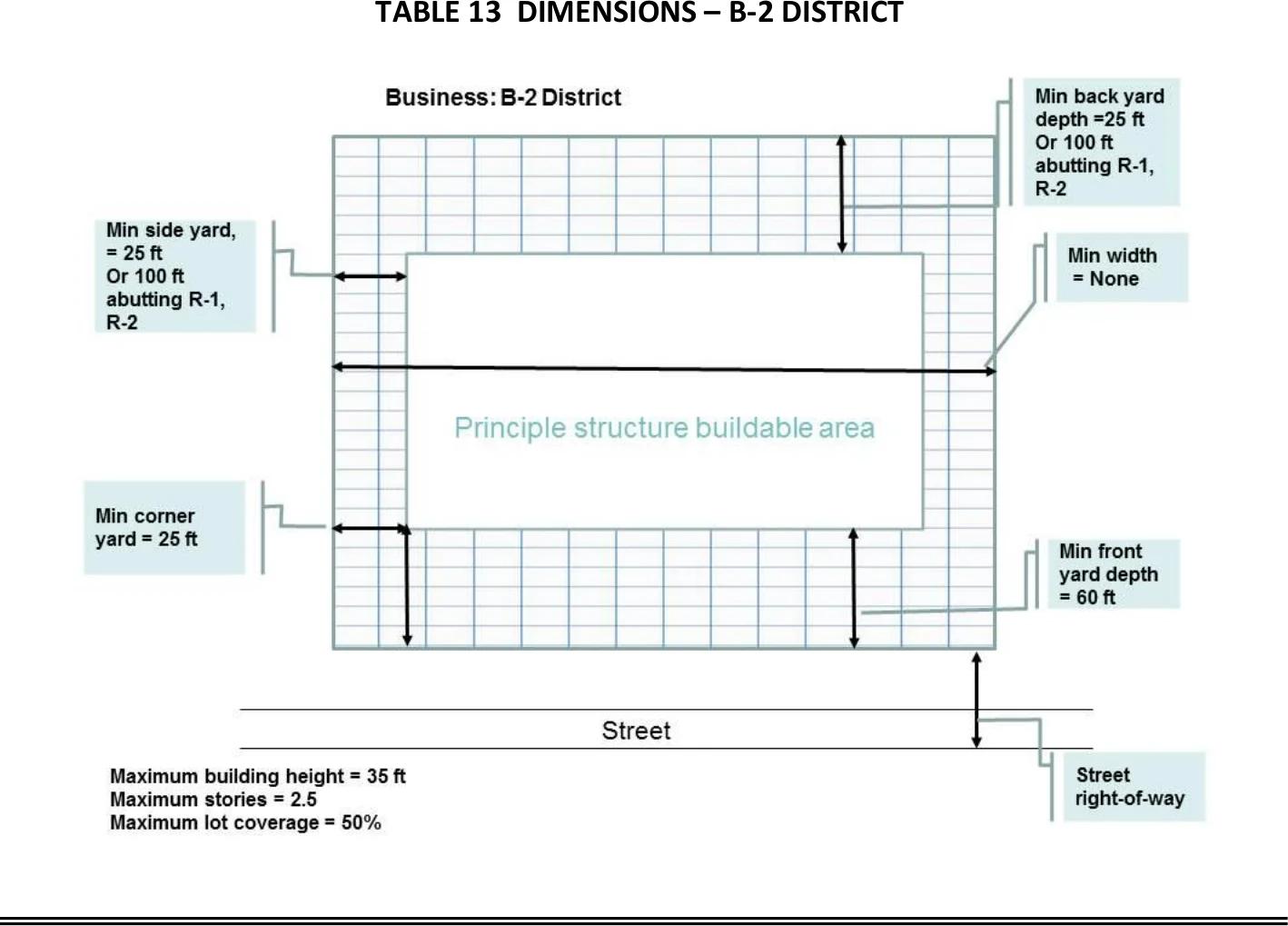 (opens the full-size diagram in a new tab)
Read a text description of this diagram
| Permitted Uses | Special Land Uses |
|---|---|
| Commercial Schools | Industrial Park |
| Contractor Storage Yards | Wireless Communication Facilities |
| Fireworks Storage | Resource Extraction |
| Fuel Sales and Gas stations | Solar Energy Facilities |
| Labs | |
| Ministorage | |
| Manufacturing | |
| Outdoor Uses | |
| Productions, processing, assembling, treatment or packaging of goods | |
| Public Service Installations | |
| Truck Terminals | |
| Vehicle Repair, Body Shops, Towing | |
| Warehouse and storage | |
| Wholesale and distributing |
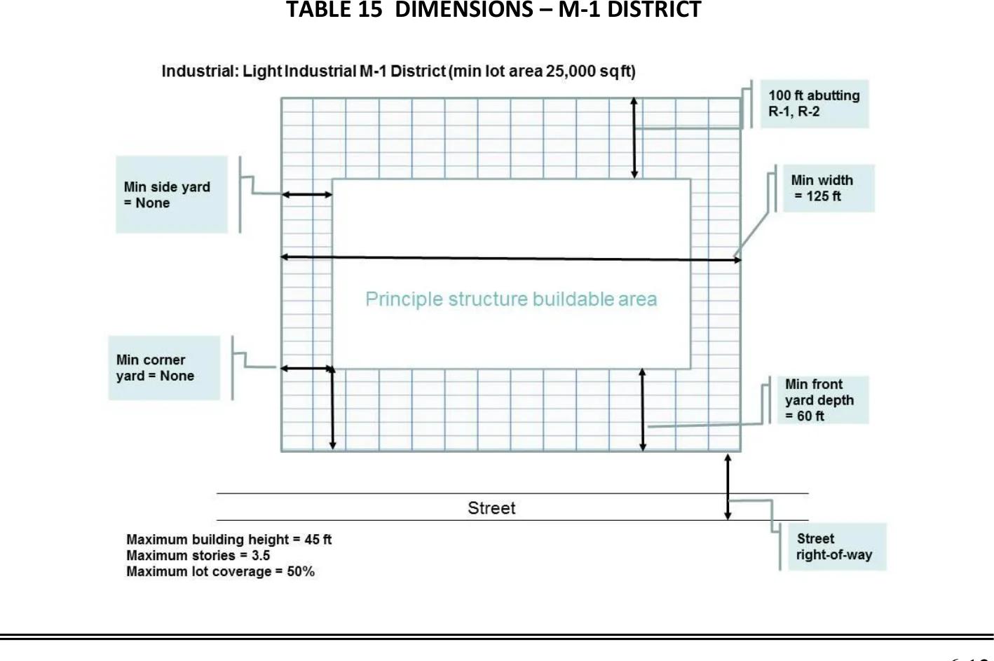 (opens the full-size diagram in a new tab)
Read a text description of this diagram
| Permitted Uses | Special Land Uses |
|---|---|
| All uses permitted by right in M-1 | All uses permitted by SUP in M-1 |
| commercial cleaning plants | |
| salvage yard, resource recovery facilities, | |
| Sewage Treatment and disposal, | |
| Sexually oriented business, adult media stores | |
| Soil extraction, pond construction | |
| storage of waste disposal vehicles | |
| Resource Extraction | |
| Solar Energy Facilities |
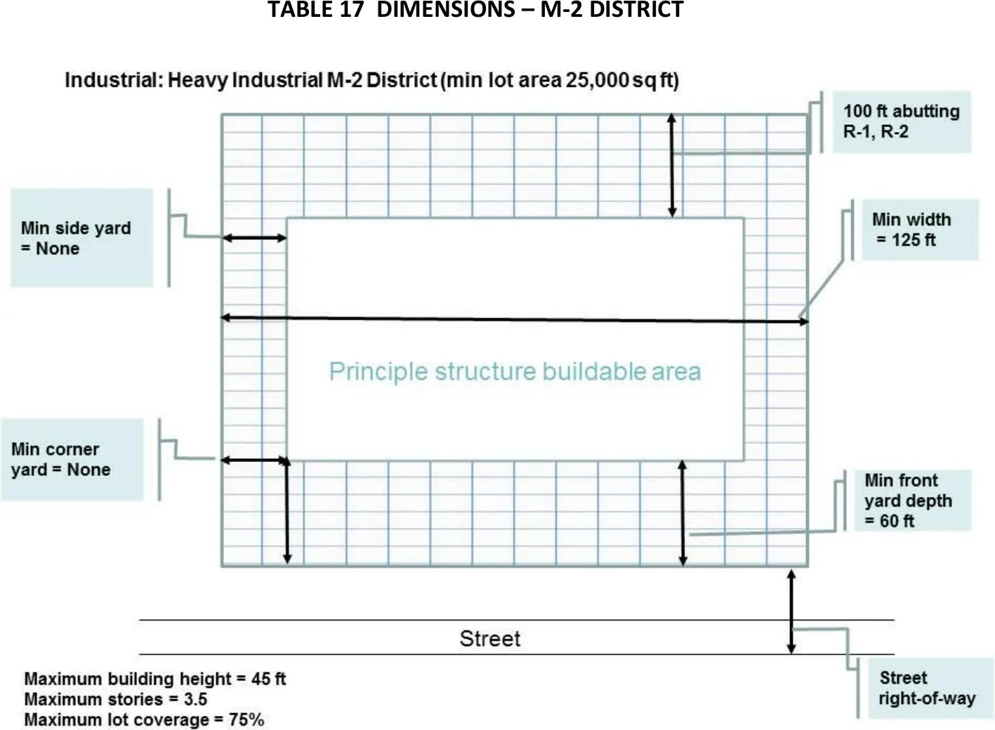 (opens the full-size diagram in a new tab)
Read a text description of this diagram
Section 6.5 General Use Requirements
- a.All outdoor storage shall be screened by a solid, uniformly finished wall or fence with solid entrance and exit gates, which fence or wall shall be at least four feet (4’) in height, but in no case lower than the enclosed storage, up to a maximum of eight feet (8’) in height. Such storage shall be deemed to include the parking of licensed motor vehicles over one and one-half (1 ½ ) tons rated capacity.
- b.USES IN THE INDUSTRIAL DISTRICT SHALL CONFORM TO THE FOLLOWING STANDARDS:
- 1)Emit no smoke, odorous gases or other odorous matter in such quantities as to be offensive at or beyond any boundary of the use of the parcel.
- 2)Shall only have vehicular access via a hard surface paved road as approved by the Midland County Road Commission, including the road system that connects it to the state and federal designated highway routes by means of an access road(s).
- 3)When adjacent to or across the road from existing residential developments or zoning districts an industrial use of a lot or parcel shall provide a screening in accordance with the zoning ordinance.
- 4)Permitted industrial uses shall be served by a public sewer service or an approved packaged sanitary treatment facility, approved by the Midland County Health Department. All packaged treatment plant facilities shall provide a minimum of secondary level treatment and shall be in conformance with all applicable federal, state and local standards and regulations. The collections system used in conjunction with a packaged treatment facility shall be located and designed to readily connect into a future public sewer service system without the need for reconstruction of any main or lateral sewer links.
Chapter 7 Special Land Use Permit Requirements
Section 7.1 Intent and Purpose
In contrast to the clear cut and objective process desired for most zoning decisions, the Special Use Permit process is intended to be at least partly subjective. It relies upon the judgment of the Planning Commissioners, the sincerity of the applicant, and the opinions or feelings of people who live or own property near the site of a proposed Special Use. The Special Uses which are designated for a particular Zoning District are generally complementary to the uses permitted by right. However, because of their unique characteristics or more intensive natures, these uses require special consideration of the welfare of adjacent properties and the community as a whole.
This Article provides procedures and standards for regulating activities identified as uses by special use permit. Special Uses represent a middle range between uses that are clearly permitted and uses that are clearly denied in any Zoning District. The purpose of designating special uses is to allow practical latitude for a property owner or developer to use a parcel of land while maintaining protection of the health, safety, comfort, convenience and general welfare of neighbors and the community at large.
Section 7.2 Permit Procedures
- a.INITIATION OF SPECIAL LAND USE. Any person having a freehold interest in land, an ownership interest entitled to exclusive possession, or a contractual interest which may become a freehold interest, and which is specifically enforceable, may file an application to use the land for one or more of the special uses provided for in this section in the zoning district in which the land is located.
- b.APPLICATION OF SPECIAL LAND USE. An application for a special use permit for any land or structure use permitted under this article shall be submitted and processed under the following procedures:
- 1)Submission of Application: Any application shall be submitted through the Zoning Administrator on a special form for that purpose. Each application shall be accompanied by the payment of a fee as established by the Township Board by resolution to cover costs of processing the application. No part of any fee shall be refundable.
- 2)Data Required: Every application shall be accompanied by the following information and data:
- a)The form supplied by the Building Inspector filled out in full by the applicant, including a statement of supporting evidence-showing compliance with the requirements of this Article.
- b)Site plan drawn to the specifications of the site plan review regulations of this Zoning Ordinance.
- c.NOTICE OF REQUEST. Upon receipt of an application for a special land use which requires a decision on discretionary grounds, one notice that a request for special land use approval has been received
shall be published in a newspaper of general circulation in the Township and shall be sent by mail or personal delivery to the owners of property for which approval is being considered, to all persons to whom real property is assessed within three hundred (300’) feet of the boundary of the property in question, and to the occupants of all structures within three hundred (300’) feet. The notice shall be given not less than five and not more than fifteen (15) days before the application will be considered. If the name of the occupant is not known, the term "occupant" may be used in making notification. Notification need not be given to more than one occupant of a structure, except that if a structure contains more than one dwelling unit or spatial area owned or leased by different individuals, partnerships, businesses, or organizations, one occupant of each unit or spatial area shall receive notice. In the case of a single structure containing more than four dwelling units or other distinct spatial areas owned or leased by different individuals, partnerships, businesses, or organizations, notice may be given to the manager or owner of the structure who shall be requested to post the notice at the primary entrance to the structure. The notice shall contain the following information.
- 1)Description of the nature of the special land use request.
- 2)Indication of the property which is the subject of the special land use request.
- 3)Statement of when and where the special land use request will be considered.
- 4)Indication of when and where written comments will be received concerning the request.
- d.AUTHORIZATION. The Zoning Administrator shall review each application for a special land use, and make a recommendation to the Planning Commission. Where applicable, the Zoning Administrator or Planning Commission shall request a written response to a site plan review from affected federal, state, county, or local agencies. The Planning Commission may deny, approve, or approve with conditions any application for a special land use. The Planning Commission shall incorporate its decision in a statement of conclusions pertaining to the special land use under consideration. The decision shall specify the basis for the decision and any conditions imposed.
No person should think that compliance with the standards defined by this Article automatically grants him or her the right to establish a special use in a given zoning district. Rather, the privilege of establishing a special use is granted or denied by the Planning Commission following the process outlined in this Article.
- e.GENERAL REQUIREMENTS FOR APPROVAL. The request for special land use approval must meet the following general standards, as well as the more specific requirements for the requested land use. The Planning Commission shall review each application for the purpose of determining that each use on its proposed location will:
- 1)Be harmonious with and in accordance with the general principals and objectives of the Master Plan of Lincoln Township.
- 2)Be designed, constructed, operated and maintained so as to be harmonious and appropriate in appearance with the existing or intended character of the general vicinity and that the use will not change the essential character of the area in which it is proposed.
- 3)Not be hazardous or disturbing to existing or future uses in the same general vicinity and will be a substantial improvement to property in the immediate vicinity and to the community as a whole.
- 4)Be served adequately by essential public facilities and services, such as highways, streets, police, fire protection, drainage structures, refuse disposal water and sewage facilities and schools.
- 5)Not involve uses, activities, processes, materials, and equipment or conditions of operation that will be detrimental to any person, property or general welfare as a result of producing excess traffic, noise, smoke, fumes, glare, odors.
- 6)Be necessary to meet the intent and purpose of the zoning regulations; be related to the standards established in this ordinance for the land use or activities under consideration; and be necessary to ensure compliance with those standards.
- f.CONDITIONS AND GUARANTEES. Prior to the granting of any special land use, the Planning Commission shall stipulate the conditions and restrictions upon the establishment, location, construction, maintenance, and operations of the special land use as deemed necessary for the protection of the public interest and to secure compliance with the standards and requirements specified. In all cases in which special land uses are granted, the Planning Commission shall require any evidence and guarantees as it may deem necessary as proof that the conditions stipulated in connection with the special land use are being, and will be, complied with. Any conditions imposed shall remain unchanged except upon the mutual consent of the Planning Commission and the landowner. The Township Clerk shall maintain a record of changes granted in the conditions. A Special Land Use is authorized and legal until the specific land use with all conditions is changed. The Special Land use then “runs with the land” regardless of the owner of the land.
- g.PERMIT EXPIRATION. A special use permit issued under this section shall be valid for a period of one (1) year from the date of the issuance of said permit. If construction has not commenced and proceeded meaningfully toward completion by the end of this period, the Building Inspector shall notify the applicant, Township Manager, Planning Commission and Township Board in writing of the expiration or revocation of said permit.
- h.EFFECT OF DENIAL OF A SPECIAL LAND USE. No application for a special land use which has been denied wholly or in part by the Planning Commission shall be resubmitted for a period of one (1) year from the date of the order of denial, except on the grounds of new evidence or proof of change of conditions found to be valid by the Zoning Administrator and the Planning Commission.
- i.REVOCATION. In any case where a special land use has not been established within one (1) year after the date of granting authorization for the use, the special land use authorization shall automatically be null and void without further action by the Planning Commission. In addition, a special land use can be revoked by the Planning Commission under the same procedure as the section used to approve it, if it is found that it no longer meets the standards of this ordinance.
Section 7.3 Automobile Car Wash, Restaurants, Bars, Taverns, Commercial Recreation
- a.MINIMUM SITE SIZE. Fifteen thousand (15,000) square feet with a minimum width of one hundred fifty (150) feet on a public dedicated or approved road.
- b.SITE LOCATION. The proposed site shall have at least one (1) property line on a principal or minor arterial.
- c.BUILDING SETBACK. All permitted buildings shall be set back sixty (60) feet from all street right-of-way lines and shall not be located closer than fifty (50) feet to any property line in a residential district unless separated from by a street or alley.
- d.No installations, except walls or fencing and permitted signs, lighting and essential services, may be constructed closer than twenty (20) feet to the line of any street right-of-way.
- e.If the use is a car wash or service station, hydraulic hoists, pits and all lubrication, greasing, automobile washing and repair equipment shall be entirely enclosed within a building.
- f.ACCESS DRIVES.
- 1)No more than one (1) driveway approach shall be permitted directly from any principal or minor arterial nor more than one (1) driveway approach from any other street, each of which shall not exceed thirty-five (35) feet in width at the property line.
- 2)Any two (2) driveways giving access to a single street should be separated by an island with a minimum dimension of twenty (20) feet at both the right-of-way and the curb or edge of the pavement.
- 3)No driveway or curb cut for a driveway shall be located within ten (10) feet of an adjoining property line and shall not be less than twenty-five (25) feet from any adjacent lot within an “R” Residential District as extended to the curb or pavement.
- 4)If the use is a car wash and the site fronts on two (2) or more streets, the driveways shall be located as far from the street intersection as practicable, but not less than fifty (50) feet.
- g.CURBING AND PAVING. A raised curb at least six (6) inches in height shall be erected along all of the street property lines, except at driveway approaches. The entire service area shall be paved with a permanent surface of concrete or asphalt.
- h.FENCING. A solid fence or wall four (4) feet in height shall be erected along all property lines abutting any lot within a residential district.
- i.LIGHTING. Exterior lighting shall be so arranged so that it is deflected away from adjacent residential districts and adjacent streets. The height of lighting shall not exceed twelve feet (12) when located within two hundred feet (200’) of a residential district and further may not exceed a height of sixteen feet (16) otherwise.
Section 7.4 Cemeteries
- a.MINIMUM SITE SIZE. One half (.5) acre.
- b.PLAY AREA. There shall be provided on the site a usable outdoor play area at the rate of fifty (50) square feet for each child not a member of the family, exclusive of required front yard, required side yard along a street, and of driveways and parking area. The play area shall be fenced for safety and shall be screened from any adjoining residential land by suitable plant material.
Section 7.5 Day Nurseries
- a.MINIMUM SITE SIZE. One half (.5) acre.
Section 7.6 Funeral Homes, Clubs, Halls
- a.DEVELOPMENT REQUIREMENTS. The following requirements for site development, together with any other applicable requirements of this Ordinance shall be complied with:
- b.MINIMUM SITE SIZE. Two (2) acres site with a minimum width of one hundred-fifty (150) feet.
- c.SITE LOCATION. The proposed site shall front upon a major or minor arterial or principal collector. All ingress and egress to the site shall be directly from said thoroughfare.
- d.YARDS. Front, side and rear yards shall be at least forty (40) feet, except on those sides adjacent to nonresidential districts wherein it shall be twenty (20) feet. All yards shall be appropriately landscaped in trees, shrubs and grass. No structures or parking areas shall be permitted in said yards, except that rear yards may be used for parking purposes under the requirements specified, and except for required entrance drives and those walls and/or fences used to obscure the use from abutting residential districts.
Section 7.7 Golf Courses, Country Clubs and Parks
- a.SITE LOCATION PRINCIPLES. Allowed use shall be located to be immediately accessible from a principal or minor arterial or collector street. Site location should be allowed which enhances the natural environment and amenities for community life.
- b.DEVELOPMENT REQUIREMENTS. The following standards shall be applicable as basic requirements for the use of land or for the erection, reconstruction or alteration of permitted structures.
- 1)Minimum site shall be fifty (50) acres or more and access shall be so designed as to provide all ingress and egress directly onto or from a collector.
- 2)Lighting shall be shielded to reduce glare and shall be so arranged and maintained as to direct the light away from all residential lands which adjoin the site. No lighting except foot lighting in parking. All signs must be backlit.
- 3)Minimum yard and height standards require that no building shall be closer than fifty (50) feet to any property or street line. No building shall be erected to a height greater than that permitted in the District in which it is located, except as may be provided under height exceptions for the District in question.
Section 7.8 Hospitals
- a.The proposed site shall be at least five acres (5) in area.
- b.The proposed site shall be at least one (1) property line abutting a public dedicated or approved road. All ingress and egress to the parking area (for guest, employees, staff) shall be directly from the major thoroughfares.
- c.All two (2) story structures shall be at least sixty (60) feet from all boundary lines or street lines. Buildings less than two (2) stories shall be no closer than forty (40) feet to any property or street line. For buildings above two (2) stories, the building shall be set back from the initial sixty (60) feet set back an additional height above two (2) stories.
- d.No more than twenty-five (25) percent of the gross site shall be covered by buildings.
- e.Ambulance and delivery areas shall be obscured from all residential view by a solid masonry wall six (6’) feet in height. Access to and from the delivery and ambulance area shall be directly from a principal or minor arterial or collector street.
Section 7.9 Industrial Park
- a.PERMITTED USES IN INDUSTRIAL PARK. Uses primarily engaged in research and light manufacturing activities.
- 1)Uses are allowed that do not have or create external noise, light, or effluents. Uses that meet these requirements are at the determination of the Planning Commission.
- 2)Distribution and Warehousing Plants
- 3)Administrative, professional, and business offices associated with and accessory to a permitted use.
- 4)Cafeteria, cafe, restaurant, or auditorium accessory with and incidental to any of the foregoing uses.
- 5)Agricultural uses, pending development.
- b.DEVELOPMENT STANDARDS.
SETBACKS. No building shall be located on any one or more lots nearer to the front lot line or nearer to the side lot line than the minimum setback set forth below:
- 1)Front Yard Setback. Twenty (20') feet, except that unsupported roofs or sun screens may project six (6') feet into the setback area.
- 2)Side Yard Setback. Ten (10’) feet, provided that a single building is constructed on two or more lots. No fences shall be constructed within the required side yard.
- 3)Rear Yard Setback. The rear yard shall be thirty (30') feet.
- c.SITE COVERAGE. Maximum building coverage of fifty (50%) percent of a Site is allowed. Parking structures shall not be calculated as a building area; however, said structures shall be used only for the parking of company vehicles, employee's vehicles, or vehicles belonging to persons visiting the subject firm.
- d.BUILDING HEIGHT. The maximum building height shall be thirty-five (35') feet.
- e.BUILDINGS PER LOT. If there is more than one (1) building on a lot, it must be approved by the Lincoln Township Planning Commission.
- f.BUILDING CONSTRUCTION AND MATERIALS. All buildings shall create a credible and acceptable appearance on all four sides. Buildings, including buildings associated with the principle structure, shall be constructed of a material other than unfinished galvanized steel or sheet aluminum for exterior walls. All appurtenant equipment, including roof mounted units, shall be screened from view from any public street.
- g.The owner shall take appropriate measures to minimize dust, storm water runoff, and construction debris during construction and shall be prohibited from allowing construction activities from injuring other properties.
- h.SIGNS. No sign shall be erected or maintained in the Park except in conformity with the following:
- 1)Signs visible from the exterior of any building may be lighted, but no signs or any other contrivance shall be devised or constructed as to rotate, gyrate, blink or move in any animated fashion.
- 2)Signs shall be restricted to advertising only the person, firm, company or corporation operating the use conducted on the site or the products produced or sold thereon.
- 3)All signs attached to the building shall be flush mounted.
- 4)Only one (1) single faced or double faced sign shall be permitted per street frontage. No sign or combination of signs shall exceed one (1) square foot in area for each six hundred (600) square feet of total site area. However, no sign shall exceed two hundred (200) square feet in area per face. An additional twenty (20) square feet shall be allowed for each additional business conducted on the site.
- 5)A sign advertising the sale, lease, or hire of the site shall be permitted in addition to the other signs listed in this section. Said sign shall not exceed maximum area of thirty-two (32) square feet.
- 6)No ground signs shall exceed four (4') feet above grade in vertical height. Also, ground signs in excess of one hundred (100) square feet in area (single face) shall not be erected in the first twenty (20') feet, as measured from the property line, of any street side set back area. However, the above standards shall not apply to the Community Directional Sign, Special Purpose Sign, Construction Sign.
- 7)Wall Signs shall be fixture signs; Signs painted directly on the surface of the wall shall not be permitted.
- i.PARKING. Each owner of a parcel shall provide adequate off-street parking to accommodate all parking needs for the parcel. Required off-street parking shall be provided on the parcel of the use served, or on a contiguous parcel or within eight hundred (800') feet of the subject parcel. Where parking is provided on other than the parcel concerned, a recorded document shall be filed with the Township and signed by the owners of the alternate parcel stipulating to the permanent reservation of the use of the parcel for said parking.
Exceptions to these guidelines shall be made where an approved Ridesharing program to service the Industrial Park is implemented.
The following guide shall be used to determine parking requirements: Office, Manufacture, Research and Assembly: One (1) space for each full time employee (per shift) and one space per two thousand (2,000) square feet of total office space (excluding such areas as pedestrian corridors, restrooms, elevator shafts, equipment areas). Warehouse: One (1) parking spaces for each full time employee (per shift).
- j.LANDSCAPING. The front yard setback area of each site shall be landscaped with an effective combination of trees, ground cover and shrubbery. All unpaved areas not utilized for parking shall be landscaped in a similar manner. The entire area between the right-of-way and a point ten (10') feet in back of the front property line shall be landscaped, except for any access driveway in said area.
- 1)Side and rear yard setback areas not used for parking or storage shall be landscaped utilizing ground cover and/or shrub and tree materials.
- 2)Undeveloped areas proposed for future expansion shall be maintained in a weed-free condition.
- k.LOADING AREAS. No loading shall be allowed which is visible from adjacent streets. Street side loading shall be allowed provided the loading dock is set back a minimum of ninety (90') feet from the street right-of-way line, or one hundred thirty (130') feet from the street center line, whichever is greater. Said loading area must be screened from view from adjacent streets.
- l.STORAGE AREAS. No outdoor storage shall be allowed.
- m.REFUSE COLLECTION AREAS. All outdoor refuse collection areas shall be visually screened from access streets, freeways, and adjacent property by a complete opaque screen made of materials compatible with the buildings materials used in the principal structure. No refuse collection areas shall be permitted between a frontage street and building line.
- n.LIGHTING. All employee, public and loading entrances shall be lighted. Lights shall be deflected in such a way as to not create a traffic hazard or affect adjoining residents.
- o.TELEPHONE AND ELECTRICAL SERVICE. All on site electrical lines and telephone lines shall be placed underground. Transformer or terminal equipment shall be visually screened from view streets and adjacent properties.
- p.NUISANCES. No portion of the Park shall be used in such a manner as to create a nuisance to adjacent sites, such as but not limited to vibration, sound, electro-mechanical disturbance, radiation, air or water pollution, dust emission of odorous, toxic or noxious matter. The result of every action or omission whereby any restriction or covenant in this document is violated in whole or in part is hereby declared to be a nuisance.
Section 7.10 Institutional Uses Including Provision for the Mentally Impaired, Drug and Alcoholic Patients
- a.The proposed site shall be at least twenty acres (20) in area.
- b.The proposed site shall have at least one (1) property line abutting a publicly or dedicated approved road.
- c.All two (2) story structures shall be at least one hundred feet (100) from all boundary lines or street lines. Buildings less than two (2) stories shall be no closer than fifty feet (50) to any property or street line. For buildings above two (2) stories, the building shall be setback the initial one hundred feet (100) and an additional one foot (1) for each foot of additional height above two (2) stories.
- d.No more than twenty-five (25%) percent of the gross site shall be covered by buildings.
- e.Ambulance and delivery areas shall be obscured from all residential view by a solid masonry wall six feet (6’) in height. Access to and from the delivery area shall be directly from a major thoroughfare.
Section 7.11 Manufactured Housing Parks
- a.PERMITTED USES
- 1)Manufactured home parks, subject to the requirements established and regulated by the Mobile Home Commission rules, and the provisions of this article.
- 2)Clubhouse, swimming pool, playgrounds, common areas and recreation facilities for the use of mobile home park residents.
- 3)Accessory uses or structures such as manufactured home park business office, laundry facilities, and home occupations otherwise permitted in residential districts under this article.
- 4)Public Service Installations
- b.COMPLIANCE WITH MOBILE HOME PARK COMMISSION
No manufactured home park shall be established unless the park complies with the rules of the Mobile Home Commission.
- c.GREENBELT BUFFER
Within the premises upon which a manufactured home park is located there shall be constructed a greenbelt buffer. After approval as a part of the preliminary plan review process, there shall be no requirement that the buffer be changed due to future development.
- 1)The greenbelt buffer shall be twenty (20') feet wide on all side and rear lot lines abutting adjoining property. Existing manufactured housing developments are not required to buffer between the existing development and any new adjacent development that did not exist at the time the preliminary plan was approved.
- 2)Landscaping Materials. If the mobile home park abuts an existing residential development, the development shall be required to provide screening along the boundary abutting the residential development. If a development abuts a nonresidential development, it need not provide screening. In all cases, however, a development shall provide screening along the boundary abutting a public right of way. The landscaping shall consist of evergreen trees or shrubs at least three feet (3’) in height, which are spaced so they provide a continuous screen at maturity. Alternative screening devices may be utilized if they conceal the manufactured home development as effectively as the required landscaping above. Property owners are allowed flexibility in material selection as long as these standards are met. If a wood fence is used, the materials shall be pressure-treated lumber. If a masonry fence is used, it shall have a foundation of at least forty-two (42") inches deep in the ground. Trees, shrubs and all planted vegetation within the buffer, must be appropriate to the climate and provided further, that they are not infested with pests, insects or diseases. The buffer shall be land-scaped in such fashion as to assure that it will not erode and shall be landscaped with grass or ground cover appropriate for the climate.
- 3)Screening shall be maintained in a condition very similar to the condition at the time of installation. This means fences shall be straight and broken boards shall be replaced. Dead trees, bushes, shrubs and vegetation shall be replaced with new, live, smaller plants which will grow to the same height as the dead plant being replaced. Masonry fences shall have all cracks repaired and maintained by pointing.
- 4)The Planning Commission shall be authorized to grant an exception from the foregoing screening requirements where the screening would serve no useful practical purpose in providing peace and quiet for the occupants of the adjoining premises and may grant any exception during the preliminary plan review process.
- d.STREETS, SIDEWALKS AND PUBLIC WAYS
Every mobile home park shall be provided with a network of streets with access points to adjacent public ways, at least as set forth hereinafter:
- 1)Access to public ways. Where adverse topographic conditions of entry streets are encountered, a second entry street must be provided. Such adverse conditions might be, but are not limited to, a stream, swamp and/or steep grade. The purpose of the second entry street is to provide adequate access to the community in cases of emergencies, poor weather or heavy traffic conditions.
- 2)All streets within the mobile home park shall be paved with a hard surface in accordance with the most recent edition of the ASSHTO Standards. Specifications for Construction that in-cludes Construction Details of the Michigan Department of Transportation.
- 3)Every street shall be provided with storm drains so as to allow for the drainage of water without flooding adjacent property or buildings, with the drains designed according to the design standards of the Michigan Department of Environmental Quality drainage standards.
- 4)Two-way streets within the mobile home park shall have a minimum traveled width of twenty-one (21’) feet of pavement with no parking. One-way streets shall have a minimum traveled width of thirteen (13’) feet with no parking. Notwithstanding the foregoing, all streets and street rights-of-way shall be of adequate width to allow for snow storage and removal. In the event that parking is permitted on any street within the mobile home park the minimum width of each street, in addition to the traveled portion, shall be ten (10) feet wide for each parallel parking lane and sixteen (16’) feet wide for each diagonal parking lane. If a parking lane is not provided, "no parking" signs will be installed and enforced on the side of the street.
- 5)Each street intersection within the mobile home park shall have an adequate safe sight distance. No object or planting shall be allowed in a yard or corner lots closer than thirty (30’) feet from the intersection or taller than three (3’) feet from the center line elevation of the street.
- 6)Each intersection within the mobile home park shall be designated by a reflective street name sign, located at the intersection, identifying each street by name.
- 7)If curbing is used, it shall be concrete with the exception of integral valley curb and gutter (gravity drains) which may be either concrete or asphalt.
- e.OFF STREET PARKING AND DRIVEWAYS
- 1)All mobile home sites within the mobile home park shall be provided with not less than two (2) hard-surfaced parking spaces. If the parking spaces are off-street, they shall be hard-surfaced and shall be sized to accommodate at least one (1) full-sized vehicle. All off-street parking shall be connected to an adjacent mobile home park street by hard-surfaced driveway at least ten (10’) feet in width. Parking may also be provided on-street, provided that the parking lane width requirements are complied with. Driveways shall also be provided for access to service entrances and buildings for delivery and collection points for fuel, refuse and other materials and elsewhere as needed. Every driveway entrance shall have a flare or radii in horizontal alignment necessary for safe and convenient ingress and egress.
- 2)A minimum of one (1) parking space for every three (3) mobile home sites shall be provided for visitor parking. Each visitor parking site shall be located within five hundred (500') feet of the mobile home site it is intended to serve. The fine hundred (500’) shall be measured along a road or sidewalk.
- 3)In addition to the foregoing, a separate parking area may be provided for vehicles that cannot be accommodated within the parking areas set forth above, such as recreational vehicles, travel trailers, snow mobiles, and the like.
- f.ILLUMINATION
All streets and sidewalk and areas open to travel by mobile home park residents shall be illuminated as follows:
- 1)Access points shall be lighted. If the public thoroughfare is lighted, the illumination level shall not exceed the average illumination level of the public thoroughfare.
- 2)At all street intersections and designated pedestrian crosswalks the minimum illumination shall be not less than 0.15 foot candles.
- 3)All streets, parking bays and sidewalks shall be illuminated at no less than 0.05 foot candles.
- g.WATER SUPPLY, FIRE HYDRANTS, AND SANITARY SYSTEM
Public sewer systems shall be required in a manufactured home development if available within two hundred (200’) feet at the time of preliminary plan approval. If a public sere system is unavailable, the development shall connect to a state approved sewage system.
- h.OPEN SPACE
An open space dedicated to use by Mobile Home Park residents as a recreation area, playground or gathering area, including, at the option of the owner/developer, clubhouses, swimming pools and the like, shall be provided. The areas shall consist of not less than two (2%) percent of the park's gross acreage but not less than twenty-five thousand (25,000) square feet. The areas shall not be included in the border greenbelt buffer and shall not be swamp or other marshland. This open space requirement shall not apply to mobile home developments with less than fifty (50) sites. If a development is built in stages, when the fifty-first site is developed, this requirement shall apply to all the sites in both stages of the development.
- i.MOBILE HOME INSTALLATION
Installation of mobile homes upon each mobile home site shall be accomplished in accordance with Part 6 of the Manufactured Housing Commission rules. All mobile homes shall be connected to utilities and shall be skirted and anchored in accordance with Part 6 of the Manufactured Housing Commission rules.
Section 7.12 Motel and Hotel, Multiple Family Dwellings, Public Buildings
Provided the following conditions are met:
- 1)Minimum floor area of two hundred-fifty square feet (250sf) per guest unit shall be provided.
- 2)Minimum lot area of forty thousand square feet (40,000sf) is required together with a minimum lot width of one hundred fifty feet (150’), plus there shall be no less than four hundred square feet (400sf) of lot area for each guest unit.
- 3)Maximum lot coverage including all buildings, both principal and accessory shall be forty (40%) percent.
- 4)Minimum yard dimensions require all building to be set back no less than forty feet (40’) from any street property line and no less than thirty feet (30’) from any side or rear property line, except that the side yard, for a corner lot, which is adjacent to the street shall be no less than forty (40’) feet.
Section 7.13 Planned Unit Development
- a.INTENT. This Section is intended to encourage innovation in land use patterns and variety in design for development of large Parcels as well as encouraging economy and efficiency in provision of public services, the use of land, natural resources and energy. These regulations provide flexibility for developers while protecting public values.
- b.PERMITTED USES AND STANDARDS. A Planned Unit Development (PUD) may include all Uses By Right and Special Uses listed for the Zoning District which applies to its site and the R-2 and B-1 Zoning Districts. When a Use is listed only as a Special Use for the applicable Zoning Districts, all Special Use Permit Standards for said Use will apply. When a Use is listed as a Special Use in one of the applicable Zoning Districts, and as a Use By Right in another, it may be treated as a Use By Right for the PUD.
- c.MAXIMUM DENSITY. The maximum density for the parcel may not exceed the allowable density for the district in which it is located.
- d.DIMENSIONAL REQUIREMENTS. Front Yard Setback requirements for the applicable Zoning District shall apply to all boundaries of the PUD. Yard requirements among lots within the PUD may be altered to meet open space requirements but may not be less than the minimum necessary to meet fifty (50%) open space requirement.
- e.OPEN SPACE. Up to fifty (50%) percent of any Parcel containing a PUD may be devoted to landscaped open space. Forest, wetland or other unique environmental areas may be left in a natural state. Cropland may not be counted as landscaped open space, nor may Yard areas of individual residential lots be included. However, landscaped yard areas for multiple dwellings or nonresidential uses may be included.
- f.PARKING AND CIRCULATION. Parking for Uses in a PUD shall conform to the requirements of individual uses as required. Roads in a PUD must be Public Streets, and must be built to the standards of the Midland County Road Commission. This does not include access drives or internal circulation in business districts.
Section 7.14 Public Utility Buildings, Telephone Exchange Buildings, Electric Transformer Stations and Substations and Gas Regulator Stations, but Not Including Storage Yards
- a.Yard and set back requirements shall be no less than that specified for the district in which the proposed use would not be located.
- b.All buildings shall be harmonious in appearance with any surrounding residential area and shall be similar in design and appearance to any other buildings on the same site development.
- c.Where mechanical equipment is located in the open air, it shall be screened from the surround residential area by suitable plant material and it shall be fenced for safety. All buildings housing mechanical equipment shall be landscaped and maintained to harmonize with the surrounding area.
Section 7.15 Religious Institutions, Temporary Outdoor Uses
- a.The proposed site shall be at least one (1) acres in size plus one-half (1/2) acre per one hundred (100) seats in the main auditorium.
- b.The proposed site shall be located as to have at least one (1) property line on an approved or dedicated road. All ingress and egress to the site shall be directly onto said thoroughfares or a marginal access service drive thereof.
- c.No building shall be closer than forty (40) feet to any property or street line. No building shall be erected to a height greater than that permitted in the district in which it is located unless the building is set back from the initial forty (40) feet an additional one (1) foot for each foot of additional height above the district height limitation.
- d.No more than twenty-five (25%) percent of the gross site area shall be covered by buildings.
Section 7.16 Sewage Treatment and Disposal, Commercial Cleaning Plants, Salvage Yard and Resource Recovery Facilities, Storage of Waste Disposal Vehicles
- a.GENERAL. All uses shall be established and maintained in accordance with all applicable State of Michigan statutes. If any of the requirements of this subsection are less than those in applicable state statutes, the state requirements shall prevail. All permitted installations shall be maintained in a neat, orderly condition so as to prevent injury to any single property and individual, or to the community in general.
- b.TREE BUFFERS FOR LANDFILLS AND JUNKYARDS. Buffers of tree cover shall be provided on the periphery of the property. The buffer shall be no less than fifty (50) feet in width, and may be natural vegetation or planted evergreens if the existing cover is destroyed.
- c.NO HAZARDOUS OR TOXIC WASTE. No hazardous or toxic wastes, as defined by the Department of Environmental Quality, may be deposited or stored by any use in this group.
- d.TRUCK ACCESS. Routes for truck movement to and from the site shall be identified by the Midland County Road Commission. Wear on public roads, traffic hazards, and encroachment of noise, dust, and other nuisances upon adjacent uses must be considered.
- e.ACTIVITY RESTRICTIONS. No open burning shall be permitted and all industrial processes involving the use of equipment for cutting, compressing (other than landfill compaction operations), or packaging shall be conducted within a completely enclosed building.
- f.FENCE REQUIREMENTS.
- 1)AROUND LANDFILL OR INCINERATOR. Berms and fences shall be constructed around any landfill or incinerator as required by the Regulations promulgated by solid waste laws of the State of Michigan. The berms and fences shall be placed on the interior of the vegetated buffers mentioned above and shall not decrease their width. Fences shall have a gate entrance which can be locked during hours when no operation is taking place.
- 2)AROUND JUNKYARD OR RESOURCE RECOVERY. A solid fence or wall at least eight (8) feet in height shall be provided around the active area of a junkyard or resource recovery operation to screen said activity from surrounding property. Such fence or wall shall be of sound construction, painted, or otherwise finished neatly and inconspicuously. All activities shall be confined within the fenced-in area. There shall be no stacking of material above the height of the fence or wall, except that moveable equipment used on the site may exceed the wall or fence height. No equipment, material, signs, or lighting shall be used or stored outside the fenced-in area. Aesthetic and structural qualities of fencing shall be regulated by the Planning Commission at the time of site plan review.
- 3)AROUND SEWAGE TREATMENT OR DISPOSAL FACILITY. All operations shall be completely enclosed by a wire link fence not less than eight (8) feet high.
- g.RESTORATION OF LANDFILL SITES. Grading or reseeding upon completion of operations in a portion of a landfill site is required. Each used portion of the site must be restored with topsoil, graded and revegetated to promote proper drainage. The restoration shall eliminate all hazards and be blended to the general surrounding ground form.
Section 7.17 Sexually Oriented Businesses and Adult Media Stores
- a.INTENT. There are some uses that because of their very nature, are recognized as having serious objectionable operational characteristics, particularly when several of them are grouped. Such uses may have deleterious effects upon the adjacent areas. Special regulation of these uses is necessary to insure that these adverse effects will not contribute to blighting or downgrade the surrounding neighborhood. These special regulations are itemized in this Section. The primary control or regulation is for the purpose of preventing a concentration of these uses in any one area or next to residential zones or certain institutional uses.
- b.DISTANCE RESTRICTIONS.
- 1)Sexually Oriented Businesses or Adult Media Stores shall not be permitted to be established within one thousand (1,000') feet of each other. This distance shall be measured from the property lot line of one Sexually Oriented Business or Adult Media Store to the property lot line of the other Sexually Oriented Business or Adult Media Store.
- 2)It shall be unlawful to hereafter establish any Sexually Oriented Business or Adult Media Store, as defined, within one thousand five hundred (1,500’) feet of any agriculturally or residentially zoned property or within one thousand five hundred (1,500’) feet of any religious or educational institution, library, day care centers, public park or recreational land use. This distance shall be measured from the property lot line of the sexually oriented business to the property lot line of the agriculturally or residentially zoned property or the property lot line of any religious or educational institution, public park or recreational land use.
- c.SIGNS AND PUBLIC OR EXTERIOR DISPLAY. Window displays, signs, decorative or structural elements of buildings shall not include or convey specific examples of actual adult uses, and are limited to the sign provisions of this Ordinance.
No Sexually Oriented Business or Adult Media Store shall be conducted in any manner that permits the observation of any material depicting, describing or relating to "specific sexual activities," "specified anatomical areas," or “Sexually oriented toys or novelties,” (as defined in this Ordinance) from any public way or from any property not licensed as a Sexually oriented Business or Adult Media Store. This provision shall apply to any display, decoration, sign, show window, structural elements or other opening.
- d.PRECAUTIONARY NOTE TO THE ZONING BOARD OF APPEALS. When considering any appeal from a Sexually Oriented Business or Adult Media Store for reduction of spacing or separation standards established herein, the Zoning Board of Appeals shall address each of the following issues and include the findings regarding each point in their minutes.
- 1)ORDINANCE INTENT. The proposed Use shall not be contrary to the intent and purpose of this Ordinance, or injurious to nearby properties.
- 2)BLIGHTING INFLUENCE. The proposed Use shall not enlarge or encourage the development of a concentration of such Uses or blighting influences.
- 3)NEIGHBORHOOD CONSERVATION. The proposed Use shall not be contrary to any program of neighborhood conservation, revitalization or urban renewal.
- 4)OTHER STANDARDS. The proposed Use, and its Principal Building, shall comply with all other regulations and standards of this Ordinance.
Section 7.18 Soil Resource Extraction, Pond Construction
- a.SCOPE OF REGULATIONS. This Section regulates extraction, filling or repositioning of soil, sand, gravel, clay or other geologic deposit involving disturbance of more than one thousand (1,000) cubic yards of material, when such disturbance is not related to construction of a building, structure, or parking lot. This Section also applies to artificial ponds created by soil excavation or intervention in watercourses, surface drainage or groundwater aquifers, regardless of size and whether the creation of the pond is an end in itself or merely a by-product of soil extraction activity. Ponds created by embankments or dams across streams or watercourses are not permitted in Lincoln Township. Finally, oil wells are specifically exempted from this Section, because they are regulated solely by the Michigan Department of Natural Resources.
- b.ADDITIONAL INFORMATION REQUIRED FOR SITE PLAN. The Site Plan for any activity regulated by this Section must include the following additional information.
- 1)A profile of the proposed excavation, illustrating elevations and changes in slope, with elevations noted in five (5) foot intervals. If water is expected to accumulate in the excavation, the projected water level must also be shown.
- 2)A soil evaluation report describing the excavation site and any needed drainage or seepage corrections.
- 3)The specifications for any spillway or drain for a proposed pond, including the proposed methods of foundation preparation or fill placement.
- c.EXCAVATION SITE REQUIREMENTS.
- 1)Avoid sites of ecological significance, such as wetlands or mature forest. If wetlands are to be affected, a State permit may be needed.
- 2)Excavations which create ponds should be located to minimize the chance of pollution from sources such as feedlots, corrals or septic tanks.
- 3)Excavations may be no closer than fifty (50') feet, measured horizontally, to a power line, and may not be within a public utility or transportation easement.
- d.CONSTRUCTION AND OPERATION REQUIREMENTS.
- 1)An excavation should not change surface drainage or underwater aquifers so as to adversely impact neighboring uses.
- 2)Any pond banks shall have a maximum slope of one (1') foot vertical to four (4') feet horizontal which extends below the projected low water surface elevation to a depth of at least eight (8') feet.
- 3)Minimum designed water depth of a pond must be fifteen (15') feet to insure proper aeration and circulation of the water.
- 4)All required environmental permits shall be obtained and obeyed, including the soil and sedimentation control permit under Act 451 of 1994.
- 5)Any excavated material not removed from the site shall be graded to a continuous slope which does not exceed one (1') foot vertical to three (3') feet horizontal and arranged to prevent runoff from impacting adjacent properties. Said fill shall blend visually with the surrounding landscape.
- 6)By October 15 of each year, the completed portion of an excavation and any disturbed area around it, shall be graded and seeded.
- 7)No machinery or equipment shall operate, and no trucks, trailers, or other conveyances shall arrive at any excavation site before 7:00 a.m. or after 8:00 p.m.
- 8)Proper measures shall be taken to minimize the nuisance of traffic noise and flying dust or soil while a site is being excavated.
- 9)When two (2) or more Dwellings are located within two hundred feet (200') of the edge of any water body on an excavation site or on any parcel, said water body shall be enclosed by a fence at least four feet (4') high with a lockable gate.
- 10)Ponds constructed for recreational purposes must be located behind the principle structure and outside of the rear and side yards.
Section 7.19 Solar Energy Facilities
The solar energy regulations and standards described in this section pertain to the creation of large-scale ground-mounted solar photovoltaic installations that primarily sell electricity to be used off site. The regulations set forth below apply to the construction, operation, and/or repair of large-scale ground-mounted Solar Energy Facilities.
If there is an application for research/development or testing of a solar panel array or equipment, these requirements may be reduced or eliminated at the request of the applicant and the discretion of the planning commission.
Solar Energy Facilities shall only be allowed as a special land use in the R-1, B-1, B-2, M-1, and M-2 zoning districts, pursuant to Chapter 7 as to Special Land Use approvals and the requirements outlined below. Land enrolled in PA 116 (Farmland and Open Space Preservation Program) is not eligible to be used for Solar Energy Facilities. These regulations are not intended to encourage land to be disenrolled in the PA 116 program.
- a.PROCEDURE. The Planning Commission review of a Special Use Permit application for a Solar Energy Facility is a two-step process. The first step is the public hearing and decision by the Planning Commission, per the procedures for review in Chapter 7. The second step, which may occur at a separate meeting for a solar energy facility, is the site plan review process by the Planning Commission as described in Chapter 8. A decision on the Special Use Permit application by the Planning Commission is inclusive of all proposed Solar Energy Facilities, underground electrical lines, sub-station(s), junction boxes, laydown yard(s), and any operations/maintenance building(s).
- b.APPLICANT IDENTIFICATION. Applicant name and address in full, a statement that the applicant is the owner involved or is acting on the owner's behalf, the address of the property involved in the application (substitution may include a legal description or parcel identifications number(s)), and any additional contact information. Each application for a Solar Energy Facility shall also be dated to indicate the date the application is submitted to Lincoln Township. The applicant, operator, and/or owner is required to place an identification placard on site with their company, address, a contact name, and a contact phone number for the life of the project.
- c.FEE. An applicant shall remit an application fee, an escrow deposit, in the amount specified by Township policy. This schedule shall be based on the cost of the application review and may be adjusted from time to time. If professional review of plans is required, then such costs shall be paid from the escrow deposit.
- d.PROJECT DESCRIPTION. A general description of the proposed project including a legal description(s) and parcel identification number(s) of the property or properties on which the project would be located and an anticipated construction schedule.
- e.PROJECT DESIGN. A description and drawing of the proposed technology to include type of solar panel and system, fixed mounted compared to solar tracking, number of panels, and angles of orientation.
- f.INSURANCE. The applicant, owner, lessee or assignee shall maintain a current insurance policy which will cover installation and operation of the Solar Energy Facility for the life of the project. The policy shall provide a minimum of $1,000,000 property and personal liability coverage per event. The applicant is required to send updated policy documents to the Township Board on an annual basis.
- g.CERTIFICATION. Certifications that applicant has complied or will comply with all applicable county, state, and federal laws, regulations, and ordinances, including compliance with the Farmland and Open Space Preservation Program (Part 361 of the Natural Resources and Environmental Protection Act, Public Act 451 of 1994 as amended, more commonly known as PA 116), and with applicable parts of the Michigan Natural Resources and Environmental Protection Act (Act 451 of 1994, MCL 324.101 et seq.) including but not limited to Part 31 Water Resources Protection (MCL 324.3101 et seq.), Part 91 Soil Erosion and Sedimentation Control (MCL 324.9101 et seq.), Part 301 Inland Lakes and Streams (MCL 324.30101 et seq.), Part 303 Wetlands (MCL 324.30301 et seq.), Part 323 Shoreland Protection and Management (MCL 324.32301 et seq.), Part 325 Great Lakes Submerged Lands (MCL 324.32501 et seq.), and Part 353 Sand Dunes Protection and Management (MCL 324.35301 et seq.). The applicant shall be responsible for
making repairs to any public roads, drains and infrastructure damaged by the construction of the Solar Energy Facility. Copies of all such permits and approvals that have been obtained or applied for at the time of the application.
- h.MANUFACTURERS' MATERIAL SAFETY DATA SHEET(S). Documentation shall include the type and quantity of all materials used in the operation of all equipment.
- i.VISUAL SIMULATIONS. Photo exhibits visualizing the proposed solar energy facility, with emphasis on visualizing the location of any required fences, landscaping, access roads, and setbacks from adjacent non-participating property.
- j.MAINTENANCE PLAN. Applicant shall submit a maintenance plan that describes the following:
- 1.Explaining routine maintenance to solar panels and facility.
- 2.Demonstrates the solar energy facility will be designed, constructed, and operated to minimize dust generation, including provision of sufficient watering of excavated or graded soil during construction to prevent excessive dust.
- 3.States the manner how unpaved access roads will be treated and maintained, either with a dust palliative or graveled or treated by another approved dust control method to prevent excessive dust.
- 4.Provisions that will be employed to maintain and promote native vegetation while minimizing the proliferation of weeds during construction and throughout the solar energy facilities’ useful life.
- k.EMERGENCY SERVICES. The solar energy facility owner or operator shall provide a copy of the project summary, electrical schematic, and site plan to the local fire chief. The owner or operator shall cooperate with local emergency services in developing an emergency response plan. All means of shutting down the solar photovoltaic installation shall be clearly marked. The owner or operator shall identify a responsible person for public inquiries throughout the life of the installation.
- l.DECOMMISSIONING. Copy of the decommissioning plans and a description of how any surety bond is applied to the decommissioning process.
- m.CONFLICT RESOLUTION. Description of the complaint resolution process.
ADDITIONAL SITE PLAN REQUIREMENTS. The applicant shall submit a site plan in full compliance with Chapter 8 of this zoning ordinance for each Solar Energy Facility and other solar energy appurtenances. Additional requirements for a Solar Energy Facility site plan are as follows:
- a.The project area boundaries.
- b.The location, height, and dimensions of all proposed structures and fencing.
- c.The location, grades, and dimensions of all temporary and permanent on-site and access roads from the nearest county or state maintained road.
- d.Existing topography.
- e.Water bodies, waterways, wetlands, drainage channels, and drain easements.
- f.A site grading, erosion control and storm water drainage plan. The plans will be reviewed by the Township’s engineering firm at the applicant’s cost.
- g.All comments from the Midland County Drain Commissioner’s office pertaining to the proposed solar energy facility shall be submitted to the Planning Commission.
- h.All new infrastructure, both above and below ground, related to the project. This includes inverters and batteries.
- i.Identification and site plan of a construction/set-up/laydown area.
STANDARDS AND REQUIREMENTS. Solar Energy Facilities shall meet the following standards and requirements:
- a.LOCATION OF SOLAR ENERGY FACILITIES
- 1.Unless otherwise specified herein, all Solar Energy Facilities must comply with the requirements established in the Lincoln Township Zoning Ordinance.
- 2.All solar energy facilities must be located on parcel(s) with a minimum lot size of 2 acres.
- 3.All fences and improved areas located on the site shall comply with the applicable setbacks for the district in which it is located. See Chapter 6 of the Zoning Ordinance.
- 4.Any structures or other improved areas located within the fenced/improved area shall be located at least 25 feet from the fence line/improved area. This requirement may be reduced or eliminated at the request of the applicant and the discretion of the planning commission.
- 5.Solar panels and associated racking is limited in height to 12 feet This requirement may be expanded or eliminated at the request of the applicant and the discretion of the Planning Commission. All other structures shall comply with the height requirements of Chapter 6.
- 6.Maximum lot coverage requirements as defined in Chapter 6 do not apply to any solar energy facility. As a part of the application, the applicant should include a maximum lot coverage calculation for reference.
- b.DESIGN AND INSTALLATION STANDARDS
- 1.All proposed facilities will comply with all applicable local, state, and federal standards and requirements, including electrical and building codes.
- 2.A copy of the application to the utility company that will be purchasing electricity from the proposed site shall be provided to the Township Planning Commission.
- 3.Any other relevant studies, reports, certificates and approval as may be reasonably required by Planning Commission.
- 4.The design and construction of Solar Energy Facilities shall not produce electrical emissions that would interfere with aircraft communications systems or navigation equipment.
- 5.If the solar energy facility consists of batteries or storage of batteries, adequate design must be provided to ensure all local, state and federal requirements regulating outdoor battery storage have been met.
- 6.No portion of the Solar Energy Facility shall contain or be used to display advertising. The manufacturers’ name and equipment information or dedication of ownership shall be allowed on any equipment of the solar energy system provided they comply with the prevailing sign regulation.
- 7.The applicant must obtain a driveway permit from the Midland County Road Commission or MDOT, as applicable.
- 8.The applicant must obtain any drain permits from the Midland County Drain Commission or MDEQ, as applicable.
- 9.The design of landscape buffers for Solar Energy Facilities shall use materials, colors, textures, screening and landscaping that will blend the facility into the natural setting and existing environment.
- 10.Lighting shall be consistent with local, state, and federal law, and shall be limited to that required for safety and operational purposes. Lighting shall be reasonably shielded from abutting properties.
- 11.Compliance with any applicable airport overlay zoning requirements and the ability to comply with FAA regulations pertaining to hazards to air navigation must be demonstrated.
- 12.If a Solar Energy Facility ownership changes, the new owner/operator must meet with the Lincoln Township Planning Commission to review the conditions of the Special Use Permit within sixty (60) days of the change in ownership.
- c.NOISE No additional noise over the existing ambient level shall be heard at the property lines of the project. If noise complaints occur, the owner/operator may be required to complete a noise study and mitigate any additional noise that is found
- d.LIGHT AND GLARE
- 1.All solar energy systems shall be placed such that solar glare does not project onto nearby inhabited structures or roadways and be considered a nuisance.
- 2.Solar facilities should be sited and designed properly to eliminate glint and glare effects on roadway users, nearby residences, commercial areas, or other highly sensitive viewing locations, or to reduce them to the lowest achievable levels. The applicant will provide a glint and glare study which accurately assesses and quantifies potential glint and glare effects and to determine the potential health, safety, and visual impacts associated with proposed project
- 3.The design and construction of solar energy facilities shall not produce light emissions, either direct or indirect (reflective), that would interfere with airline pilot vision and/ or traffic control operations.
- e.LANDSCAPING
- 1.Applicant shall submit a landscape plan detailing all proposed changes to the landscape of the site, including temporary or permanent roads or driveways, grading, vegetation clearing and planting.
- 2.Land clearing of natural vegetation shall be limited to that which is necessary for the construction, operation, and maintenance, of the solar energy facility pursuant to practices of best management of natural areas or good stewardship of the land or forest otherwise prescribed by applicable laws, regulations and bylaws.
- 3.Each owner, operator or maintainer of a solar energy facility to which this Ordinance applies shall utilize good plant husbandry techniques with respect to vegetation, including but not limited to, proper pruning, proper fertilizer, and proper mulching, so that the vegetation will reach maturity as soon as practical and will have maximum density in foliage. Dead or diseased vegetation shall be removed and must be replanted at the next appropriate planting time. Low level vegetation, cover plants, or grasses shall be maintained by the facility operator not to exceed 12 inches in height.
- 4.All solar energy facilities shall have a minimum landscape buffer of 10 feet in width. The buffer shall contain evergreen trees or bushes planted no more than 8 feet apart and at least 4' tall at time of planting. The trees or bushes may be trimmed no lower than a height of 10 feet. In place of this buffer, the Planning Commission may also allow a minimum 5 feet high berm or solid fencing as a landscape buffer. The fence cannot exceed the 6-foot fence maximum and must be a minimum of 4 feet. These landscaping requirements may be reduced or eliminated at the request of the applicant and the discretion of the Planning Commission. Such request may occur when the adjacent use is agricultural or industrial and there is insufficient reason to buffer the solar energy facility as a more intensive or intrusive land use.
- 5.Applicant must provide a detailed maintenance plan for the proposed solar energy system, and surrounding area, including provisions that will be employed to maintain and promote native vegetation while minimizing the proliferation of weeds during and following construction.
- f.SECURITY
- 1.The manufacturers or installer's identification and appropriate warning sign shall be posted on or near the panels in a clearly visible manner; furthermore, an information sign shall be posted and maintained at the entrance(s), which shall list the name and phone number of the operator
- 2.Solar energy facilities shall be surrounded by a minimum of a six-foot tall chain link fence that shall be designed to restrict unauthorized access. The planning commission may modify this requirement if deemed appropriate.
Abandonment and Decommissioning.
- a.ABANDONMENT: A Solar Energy Facility that ceases to produce energy on a continuous basis for 12 months will be considered abandoned unless the current responsible party (or parties) with ownership interest in the Solar Energy Facility provides substantial evidence (updated every 6 months after 12 months of no energy production) to the Planning Commission or its designee of the intent to maintain and reinstate the operation of that facility. It is the responsibility of the responsible party (or parties) to remove all equipment and facilities and completely restore the Parcel to its condition prior to development of the Solar Energy Facility.
- 1.Upon determination of abandonment, the Zoning Administrator shall notify the party (or parties) responsible that they must remove the Solar Energy Facility and restore the site to its condition prior to development of the Solar Energy Facility within six months of notice by the Planning Commission or its designee.
- 2.If the responsible party (or parties) fails to comply, the Planning Commission or its designee may remove the Solar Energy Facility, sell any removed materials, and initiate judicial proceedings or take any other steps legally authorized against the responsible parties to recover the costs required to remove the Solar Energy Facility and restore the site to a nonhazardous predevelopment condition.
- b.DECOMMISSIONING: A decommissioning plan signed by the party responsible for decommissioning and the landowner addressing the following shall be submitted prior to the issuance of the zoning permit, which shall include:
- 1.The anticipated life of the project;
- 2.The estimated decommissioning costs in current dollars (salvage costs cannot be considered in the estimated decommissioning costs). The estimate shall be prepared by the engineer for the developer and shall be approved by the Township.
- 3.The method of ensuring that funds will be available for decommissioning and restoration, to include but not limited to:
- 4.Complete removal of all non-utility owned equipment, conduit, structures, fencing, roads, solar panels and foundations, and
- 5.Complete restoration of property to condition prior to development of the Solar Energy Facility;
- c.The anticipated manner in which the project will be decommissioned and the site restored.
- 1.Decommissioning shall include the removal of each PV Panel, all electrical components, and associated facilities within the footprint of the solar energy facility to a depth of 48 inches below grade. However, the landowner may submit a request allowing the concrete foundations to be left for other uses, subject to the Zoning Administrator.
- 2.Following removal, the location of any remaining foundation shall be identified on a map and recorded with the deed to the property with the Midland County Register of Deeds.
- 3.All access roads to the Solar Energy Facility shall be removed, cleared, and graded by the facility owner, unless the property owner requests, in writing, a desire to maintain the access road. The Township will not be assumed to take ownership of any access road and such remaining roads will not be considered public roads.
- 4.The site and any disturbed earth shall be stabilized, graded, and cleared of any debris by the owner of the Solar Energy Facility or its assigns. If the site is not to be used for agricultural purposes following removal, the site shall be seeded to prevent soil erosion, and restored to
its condition existing prior to any construction activities, unless the property owner requests, in writing, that the land surface areas not be restored.
- d.A provision to give notice to the Township one year in advance of decommissioning.
- e.A surety bond to assure payment of the cost of decommissioning shall be required. To ensure proper removal of the structure when it ceases to be used for a period of one year or more, any application for a new solar energy facility shall include a description of the financial security guaranteeing removal of the solar energy facility which will be posted at the time of receiving a building permit for the facility. The security shall be a: 1) cash bond; 2) irrevocable bank letter of credit; or 3) performance bond in a form approved by the Township. The amount of such guarantee shall be no less than the estimated cost of removal and may include a provision for inflationary cost adjustments.
- f.A condition of the Surety Bond shall be notification by the surety company to the Township Zoning Administrator thirty (30) days prior to its expiration or termination. When determining the amount of such required security, the Township may also require future meetings at pre-set intervals, to establish corrected values for decommissioning. The financial security instrument shall be adjusted to each determined corrected value.
- g.The time frame for completion of decommissioning activities.
Complaint Resolution.
- a.The applicant shall develop a process to resolve complaints from nearby residents concerning the construction or operation of the project. All complaints shall be acknowledged within 10 days of receipt of such complaint and the Township supervisor shall also be notified of each complaint. The process may use an independent mediator or arbitrator and shall include a time limit for acting on a complaint. The process shall not preclude the local government from acting on a complaint.
- b.During construction, the applicant shall maintain and make available to nearby residents a telephone number where a project representative can be reached during normal business hours.
- c.A report of all complaints and resolutions to complaints shall be filed with the township on a quarterly basis.
CONFLICTING PROVISIONS. In the event of a conflict between any provision in this section and any other section of this Zoning Ordinance with regard to Solar Energy Facilities, the provisions of this section shall control.
Section 7.20 State Licensed Residential Facility
- a.This section applies State Licensed Residential Facilities for seven (7) to twenty (20) persons in accordance with the Adult Foster Care Facility Licensing Act, 1979 PA 218, MCL 400.701 to 400.737.
- b.SITE LOCATION PRINCIPLES. The following principles shall be utilized to evaluate the proposed location of any institutional use within a permitted district. These principles are alterable, depending upon the specific conditions of each situation, but they shall be applied by the Planning Commission as general guidelines to help assess the impact of an institutional use upon the District in which such use is proposed to be located.
- 1)Any institutional structure or use to be located within a residential district should preferable be located at the edge of a residential district, abutting either a business or industrial district or adjacent to a public open space.
- 2)Motor vehicle entrance should be made on a Principal Arterial or as immediately accessible from a Principal Arterial as to avoid the impact of traffic generated by the institutional use upon a residential area.
- 3)Site locations should be preferred that offer natural or man-made barriers that would lessen the effect of the intrusion of the institutional use into a residential area.
Section 7.21 Tattoo and Piercing Parlor
- a.LOCATION. Tattoo and piercing parlors shall not be permitted to be established within one thousand (1000) feet of a school, day care or religious institution. This distance shall be measured from the property line.
- b.SEPARATION. Tattoo and piercing parlors shall not be permitted to be established within one thousand (1000) feet of each other. This distance shall be measured from the property line.
Section 7.22 Wireless Communication Facilities
- a.INTENT AND PURPOSE. The intent and purpose of these regulations is to accommodate the communications needs of people while protecting the public health, safety and general welfare of the community. These regulations will:
- 1)Facilitate the provision of wireless telecommunication services to the residents and businesses of the Township,
- 2)Minimize adverse visual effects of towers through design and siting standards,
- 3)Avoid potential damage to adjacent property from tower failure through structural standards and setback requirements, and
- 4)Maximize the use of existing approved towers and buildings to accommodate new wireless telecommunication facilities in order to reduce the number of towers necessary to serve the community.
- b.DISTRICT REGULATIONS. A wireless communication facility shall require a building permit in all instances and may be permitted as follows:
- 1)A Wireless Service Facility may locate on any existing guyed tower, lattice tower, monopole, electric utility transmission tower, fire tower, or water tower, provided that the installation of the new facility does not increase the height of the existing structure except as provided in the Height Regulations in this Ordinance. Such installations shall be permitted by right in all zoning districts and be permitted through the site plan review process by the Planning Commission.
- 2)Towers in non-industrially zoned areas are only allowed if they are:
- a)Towers supporting amateur radio antennas and conforming to all applicable provisions of this ordinance shall be allowed in the rear yard of parcels.
- b)Towers supporting commercial antennas and conforming to all applicable provisions of this Ordinance shall be allowed only in the following locations by right and shall be permitted through the site plan review procedures only and are not required to obtain a special use permit.
- (1)Religious institutions, when camouflaged as steeples or bell towers;
- (2)Park sites, when compatible with the nature of the park; and,
- (3)Government, school, utility and institutional sites, according to the Statement of Priority of users and minimum requirements for use of Township owned properties.
- (4)Wireless telecommunication antennas on roofs, walls and existing towers may be approved by the Township staff provided the antennas meet the requirements of this ordinance after submittal of a final site plan and a report prepared by a licensed professional engineer indicating the existing structure or tower's suitability to accept the antenna and the proposed method for affixing the antenna to the structure. Complete details of all fixtures and couplings and the precise point of attachment shall be indicated.
- c)The telecommunications equipment planned for the proposed tower cannot be accommodated on an existing or approved tower or building within a two (2) mile radius of the proposed tower location due to one or more of the following reasons:
- (1)The planned equipment would exceed the structural capacity of the existing or approved tower or building, as documented by a qualified and licensed engineer, and the existing or approved tower cannot be reinforced, modified, or replaced to accommodate planned or equivalent equipment at a reasonable cost.
- (2)The planned equipment would cause interference materially impacting the usability of other existing or planned equipment at the tower or building as documented by a qualified and licensed professional engineer and the interference cannot be prevented at a reasonable cost.
- (3)Existing or approved towers and buildings within the search radius cannot accommodate the planned equipment at a height necessary to function reasonable as documented by a qualified and licensed professional engineer.
- (4)Other unforeseen reasons make it infeasible to locate the planned telecommunications equipment upon an existing or approved tower or building.
- d)A tower structures built by other than a licensed carrier may not be constructed until at least two carriers have been secured to occupy the structure. Contracts with such carriers will be required by the Township as proof that two carriers will occupy the structure.
- c.COLLOCATION. Licensed carriers shall share wireless service facilities and sites where feasible and appropriate, thereby reducing the number of wireless service facilities that are stand-alone facilities. All applicants for a Special Use Permit for a wireless service facility shall demonstrate a good faith effort to collocate with other carriers. Such good faith effort includes:
- 1)A survey of all existing structures that may be feasible sites for collocating wireless service facilities,
- 2)Contact with all the other licensed carriers for commercial mobile radio services operating in the County and,
- 3)Sharing information necessary to determine if collocation is feasible under the design configuration most accommodating to collocation.
- 4)In the event that collocation is found to be infeasible, a written statement of the reasons for the lack of feasibility shall be submitted to the Township. The Township may retain a technical expert in the field of RF engineering to verify if collocation at the site is not feasible or is feasible given the design configuration most accommodating to collocation. The cost for such a technical expert will be at the expense of the applicant. The Township may deny a Special Use Permit to an applicant that has not demonstrated a good faith effort to provide for collocation.
- d.TOWER CONSTRUCTION. Any proposed commercial wireless telecommunication service tower shall be designed, structurally, electrically, and in all respects to accommodate both the applicant's antennas and comparable antennas for at least two additional users. Towers must be designed to allow for future rearrangement of antennas upon the tower and to accept antennas mounted at varying heights. Towers shall be constructed to ANSI EIA TIA-222-F "Structural Standards for Steel Antenna Towers and Antenna Supporting Structures" and National Building Code construction standards for steel structures.
- e.TOWER, ANTENNA AND ACCESSORY BUILDING DESIGN. Proposed or modified towers and antennas shall meet the following design requirements:
- 1)Towers and antennas shall be designed to blend into the surrounding environment through the use of color and camouflaging architectural treatment, except in instances where the color is dictated by federal or state authorities such as the Federal Aviation Administration.
- 2)Commercial wireless telecommunication service towers shall be of a monopole design unless the Township Board determines that an alternative design would better blend into the surrounding environment.
- 3)Accessory Utility Cabinets and Buildings. All utility buildings and structures accessory to a transmission structure shall be architecturally designed to blend in with the surrounding environment and shall meet the minimum setback requirements of the underlying zoning district. Ground mounted equipment shall be screened from view by suitable vegetation, except where a design of non-vegetative screening better reflects and complements the architectural character of the surrounding neighborhood.
- f.TOWER SETBACKS. Towers shall conform with each of the following minimum setbacks requirements:
- 1)Towers shall meet the setbacks of the underlying zoning district with the exception of industrial zoning districts, where towers may encroach into the rear setback areas, provided that the rear property line abuts another industrially zoned property and the tower does no encroach upon any easements.
- 2)Towers shall be set back from planned public right-of-ways as shown on the Township's Master Plan by a minimum distance equal to the height of the tower including all antennas and attachments.
- 3)Towers shall not be located between a principal structure and a public street, with the following exceptions:
- a)In industrial zoning districts, towers may be placed within a side yard abutting an internal industrial street.
- b)On sites adjacent to public streets on all sides, towers may be placed within a side yard abutting a local street.
- 4)Tower's setback may be reduced or its location in relation to a public street varied, at the discretion of the Township Planning Commission to allow the integration of a tower into an existing or proposed structure such as a church steeple, light standards, power line support device, or similar structure.
- 5)Towers and associated structures, including fencing, may not be constructed within five hundred (500') feet of a dwelling unit, except where they are being collocated on existing towers or structures.
- g.TOWER HEIGHT. In all zoning districts, the maximum height of any tower, including antennas and other attachments, shall not exceed 200' except as granted by the Zoning Board of Appeals.
- h.TOWER LIGHTING. Towers shall not be illuminated by artificial means and shall not display strobe lights unless such lighting is specifically required by the Federal Aviation Administration or other federal or state authority for a particular tower. When incorporated into the approved design of the tower, light fixtures used to illuminate ball fields, parking lots or similar areas may be attached to the tower.
- i.SIGNS AND ADVERTISING. The use of any portion of a tower for signs or other forms of advertising other than warning or equipment information signs are prohibited.
- j.ABANDONED OR UNUSED TOWERS OR PORTIONS OF TOWERS. Abandoned or unused towers or portions of towers shall be removed as follows:
- 1)All abandoned or unused towers and associated facilities shall be removed within twelve (12) months of the cessation of operations at the site unless a time extension is approved by the Zoning Administrator. A copy of the relevant portions of a signed lease which requires the applicant to remove the tower and associated facilities upon cessation of operations at the site shall be submitted at the time of application. In the event that a tower and associated facilities is not
removed within twelve (12) months of the cessation of operations at a site, the tower and associated facilities may be removed by the Township and the costs of removal assessed against the property.
- 2)Unused portions of towers above a manufactured connection shall be removed within six (6) months of the time of antenna relocation. The replacement of portions of a tower previously removed requires the issuance of a new special use permit.
- k.INTERFERENCE WITH PUBLIC SAFETY TELECOMMUNICATIONS. No new or existing telecommunications service shall interfere with public safety telecommunications. The Planning Commission may request an intermodulation study which provides a technical evaluation of existing and proposed transmission and indicates all potential interference problems. Before the introduction of new service or changes in existing service, telecommunication providers shall notify the Township at least ten calendar days in advance of such changes and allow the Township to monitor interference levels during the testing process.
- l.MODIFICATIONS. A modification of a wireless service facility may be considered equivalent to an application for a new wireless service facility and will require a Special Use Permit when the following events apply:
- 1)The applicant and/or co applicant wants to alter the terms of the Special Use Permit by changing the wireless service facility in one or more of the following ways:
- a)Change in the number of facilities permitted on the site.
- b)Change in the technology used for the wireless service facility.
- 2)The applicant and/or co applicant wants to add any equipment or additional height not specified in the original design filing.
- 1)The applicant and/or co applicant wants to alter the terms of the Special Use Permit by changing the wireless service facility in one or more of the following ways:
- m.SITE PLAN SUBMISSION REQUIREMENTS.
- 1)General Filing Requirements
- a)Name, address and telephone number of applicant and any co-applicants as well as any agents for the applicant or co-applicants.
- b)Co-applicants may include the landowner of the subject property, licensed carriers and tenants for the personal wireless service facility.
- c)Original signatures for the applicant and all co-applicants applying for the Special Permit. If the applicant or co-applicant will be represented by an agent, original signature authorizing the agent to represent the applicant and/or co-applicant. Photo reproductions of signatures will not be accepted.
- 2)Location Filing Requirements
- a)Identify the subject property by including the Town as well as the name of the locality, name of the nearest road or roads, and street address, if any.
- b)Tax map and parcel number of subject property.
- c)Zoning district designation for the subject parcel.
- d)A line map to scale showing the lot lines of the subject property and all properties within 300 feet and the location of all buildings, including accessory structures, on all properties shown.
- 3)Siting Filing Requirements
A one-inch-equals-40 feet vicinity plan showing the following:
- a)Property lines for the subject property.
- b)Property lines of all properties adjacent to the subject property within 300 feet.
- c)Tree cover on the subject property and adjacent properties within 300 feet, by dominant species and average height, as measured by or available from a verifiable source.
- d)Outline of all existing buildings, including purpose (e.g. residential buildings, garages, accessory structures, etc.) on subject property and all adjacent properties within 300 feet.
- e)Proposed location of antenna, mount and equipment shelter(s).
- f)Proposed security barrier, indicating type and extent as well as point of controlled entry.
- g)Location of all roads, public and private, on the subject property and on all adjacent properties within 300 feet including driveways proposed to serve the personal wireless service facility.
- h)Distances, at grade, from the proposed personal wireless service facility to each building on the vicinity plan.
- i)All proposed changes to the existing property, including grading, vegetation removal and temporary or permanent roads and driveways.
- j)Representations, dimensioned and scale, of the proposed mount, antennas, equipment shelters, cable runs, parking areas and any other construction or development attendant to the personal wireless service facility.
- 4)Siting elevations, or views at-grade from the north, south, east and west for a 50-foot radius around the proposed personal wireless service facility plus from all existing public and private roads that serve the subject property. Elevations shall be at either one-quarter inch equals one foot or one-eighth inch equals one foot scale and show the following:
- a)Antennas, mounts and equipment shelter(s), with total elevation dimensions and AGL of the highest point.
- b)Security barrier. If the security barrier will block views of the personal wireless service facility, the barrier drawing shall be cut away to show the view behind the barrier.
- c)Any and all structures on the subject property.
- d)Existing trees and shrubs at current height and proposed trees and shrubs at proposed height at time of installation, with approximate elevations dimensioned.
- e)Design Filing Requirements
- (1)Equipment brochures for the proposed personal wireless service facility such as manufacturer's specifications or trade journal reprints shall be provided for the antennas, mounts, equipment shelters, cables as well as cable runs, and security barrier, if any.
- (2)Materials of the proposed personal wireless service facility specified by generic type and specific treatment (e.g., anodized aluminum, stained wood, painted fiberglass, etc.). These shall be provided for the antennas, mounts, equipment shelters, cables as well as cable runs, and security barrier, if any.
- (3)Dimensions of the personal wireless service facility specified for all three directions: height, width and breadth. These shall be provided for the antennas, mounts, equipment shelters and security barrier, if any.
- (4)Landscape plan including existing trees and shrubs and those proposed to be added, identified by size of specimen at installation and species.
- (5)If lighting of the site is proposed, the applicant shall submit manufacturers computer generated point to point printout, indicating the horizontal foot candle levels at grade, within the property to be developed and twenty-five (25') feet beyond the property lines. The printout shall indicate the locations and types of luminaries proposed.
- f)Radio Frequency Radiation (RFR) Filing Requirements. The Planning Commission reserves the right to request RFR requirements in the form of a certification that the following studies have been completed. The applicant shall provide a statement listing the existing and maximum future projected measurements of RFR from the proposed personal wireless service facility, for the following situations:
- (1)Existing, or ambient: the measurements of existing RFR.
- (2)Existing plus proposed personal wireless service facilities: maximum estimate of RFR from the proposed personal wireless service facility plus the existing RFR environment.
- (3)Certification, signed by a RF engineer, stating that RFR measurements are accurate and meet FCC Guidelines as specified in the Radio Frequency Radiation Standards sub-section of this Bylaw.
In all cases the applicant shall provide a letter from emergency service providers within the coverage area of the proposed facility stating that emergency services will not be adversely impacted by the proposed facility.
Chapter 8 Site Plan Review
Section 8.1 Purpose
Before a building permit is issued a site plan shall be submitted to the Planning Commission for review and approval. Before granting approval, the Planning Commission shall ascertain that all provisions of this Article and the Lincoln Township Land Division Ordinance, as applicable, are complied with and that the proposed location and arrangement of buildings, accesses, parking areas, walkways, yards, open areas, and other improvements produce no potential health, safety, or protection hazards, and that the arrangement of buildings and structures will provide convenience for the intended occupants or utilization by the public and will be harmonious with development on adjacent properties.
Section 8.2 Scope
- a.The following buildings, structures, or uses shall be exempt from site plan review and procedures.
- b.Single or two family homes under separate ownership on an individual and separate lot for each home, and including Accessory Uses.
- c.Interior, accessory, and subordinate buildings that require no new or additional means of access thereto from adjoining public roads or highways and complying with all zoning ordinance requirements.
- d.Projects involving the expansion, remodeling, or enlargement of existing buildings which comply with all zoning ordinance requirements and involve no new or additional means of access thereto from adjoining public roads or highways and require no additional parking. Appearance standards apply to all new, expanded, remodeled, or enlarged buildings exceeding fifty (50%) percent of existing floor area or building facade surface.
- e.On premises advertising signs providing they conform to this ordinance.
Section 8.3 Application Procedure
Requests for site plan review shall be made on a site plan review form using the site plan checklist provided for in the developer. The components of the site plan checklist shall be completed before the site plan is reviewed by the Planning Commission. Incomplete site plans or site plans on land not reviewed and approved by the assessor as portrayed on the site plan, will not be accepted for review. All site plans must be stamped by a licensed professional engineer, architect, landscape architect or surveyor.
Section 8.4 Action on Application and Plans
- a.REVIEW OF A SITE PLAN OUTSIDE OF A PLAT:
- A.The Zoning Administrator shall record the date of the receipt of the application and plans, and shall transmit copies to the Planning Commission, the Township Zoning Administrator, the Township Engineer, the Police Chief and Fire Chief, and copies to the other affected Township Departments and professionals as the Township deems necessary. It is strongly advised that all applicants discuss their site plan with the Township staff prior to review by the Planning Commission. Applications for Appearance Code approval only, related to modification (not expansion) of an existing structure, shall be submitted only to the Planning Commission.
- B.Where it is evident to the Zoning Administrator, professional consultants or the Planning Commission that the proposed use will have an impact upon any public facility, right-of-way or easement, the applicant shall submit the site plan to the appropriate state, county or local agency(s) that has an impact upon, or will be impacted by, the proposed land use and shall request the appropriate agency(s) to review the proposed land use and submit a written response to the Zoning Administrator or Planning Commission describing the potential impact of the project and the agency’s recommendations for approval, disapproval or modifications.
The Township and/or Planning Commission may request a traffic impact analysis in cases where the location, nature of the use or specific circumstances indicate traffic and/or access management issues require professional analysis. This impact study shall be at the expense of the applicant. Permits for driveways, obtained prior to official approval of a site plan by the Planning Commission shall not constitute approval for construction and are subject to approval by the Planning Commission.
- C.A public meeting shall be scheduled by the Planning Commission for a review of the application and plans as well as reviewing the recommendations of Township staff and professionals. Members of the Planning Commission shall be delivered copies of the application and plans prior to the public meeting for their preliminary information and study. The meeting shall be scheduled not more than forty (40) days following the date of the receipt of the plans and application by the Zoning Administrator. (Amended 4/23/02)
- D.The applicant shall be notified of the date, time and place of the public meeting on his application not less than fifteen (15) days prior to that date.
- E.Following the public meeting, the Planning Commission shall have the authority to approve, disapprove, modify or alter the proposed plans in accordance with the purpose of the site plan review provisions of this section and the criteria contained herein. Any required modification or alteration shall be stated in writing, together with the reasons for the modification, and delivered to the applicant. The Planning Commission may either approve the plans contingent upon the required alterations or modifications, if any, or may require a further review after the modifications have been included in the proposed plans for the applicant. The decision of the Planning Commission shall be made within forty (40) days of receipt of the application by the Zoning Administrator. If the decision is not made within the forty (40) day period, the appeal shall be considered approved.
- F.Two (2) copies of the approved final plan/design, including any required modifications or alterations, shall be maintained as part of the Township records for future review and/or enforcement. Each copy shall be signed and dated by the Chairman of the Planning Commission for identification of the final, approved plans, as well as signed and dated by the applicant. If any variances from the zoning ordinance have been obtained from the Zoning Board of Appeals, the minutes concerning the variances duly signed shall also be filed with the Township records as a part of the plan/design and delivered to the applicant for his information and direction. The plan/design shall become part of the record of approval, and subsequent actions relating to the activity authorized shall be consistent with the approved site plan, unless a change conforming to this section receives the mutual agreement of the landowner and the Planning Commission.
- b.PROCESS FOR REVIEW OF A PLAT
A plat shall be reviewed in the same manner as a site plan and as described in this Article, except that a plat shall be submitted for review at two separate stages in the development of the plat and in accordance with the Subdivision Control Act of 1967, as amended, P.A. 288.
- A.The Tentative Preliminary Plat. This plat shall be submitted showing all aspects of the plat as required for site plans, including any additional information requested by the Planning Commission. Following approval of the Tentative Preliminary Plat, a Preliminary Plat shall be submitted.
- B.The Preliminary Plat shall be considered the final site plan for the development. Prior to approval of a Preliminary Plat, the applicant shall present written approval from the Midland County Road Commission, the Department of Environmental Quality and the Midland County Drain Commissioner. The Tentative and Preliminary Plats may be reviewed and approved simultaneously at the discretion of Township staff if all requirements of the Zoning Ordinance have been satisfied and there are no outstanding issues that would prevent a combined review.
Section 8.5 Criteria for Review
In reviewing the application and site plan and approving, disapproving, or modifying the plan, the Planning Commission shall be governed by the following general standards, in addition to any other site plan standards contained in any other area of this Ordinance.
- a.TRANSPORTATION. There is a proper relationship between the existing streets and highways within the vicinity and proposed acceleration and/or deceleration lanes, service drives, entrance and exit driveways, and parking areas to insure the safety, as the primary goal, and convenience as the secondary goal, of pedestrian and vehicular traffic and access management principles have been followed.
- b.NATURAL FEATURES. As many natural features of the landscape shall be retained as possible where they furnish a barrier screen, or buffer between the project and adjoining properties used for dissimilar purposes and where they assist in preserving the general appearance of the neighborhood.
- c.DRAINAGE.
- A.All development shall retain storm water runoff on-site, or detain it so as to allow discharge without any impact on adjacent lands, streams or water bodies above the existing pre-development runoff impact. If the Midland County Drain Commissioner’s approval is required, it shall be submitted to the Township Planning Commission.
- B.All development shall conform to the soil erosion and sedimentation regulations of Midland County and any special regulations of the Midland County Drain Commission.
- C.No new development shall be permitted, which will reduce the level of service currently being provided by existing storm water management infrastructure to such infrastructure or existing storm water drainage patterns unless necessary improvements to such infrastructure or natural drain pattern are first made to ensure pre-development service loads.
- D.Existing natural drainage shall be maintained to maximum extent feasible.
- d.ADVERSE EFFECTS OF DEVELOPMENT. Any adverse effects of the proposed development and activities emanating from which affect adjoining residents or owners shall be minimized by appropriate screening, fencing, landscaping, setback, and location of buildings, structures, and entryways.
- e.LAYOUT. The layout of buildings and improvements will minimize any harmful or adverse effect which the development might otherwise have upon the surrounding neighborhood.
- f.LAND DIVISION ORDINANCE. The site plan must comply with all provisions of the Zoning Ordinance and the Lincoln Township Land Division Ordinance, as applicable. However, this would not preclude the applicant from applying for an appropriate variance with the Zoning Board of Appeals. The Planning Commission may conditionally approve a site plan subject to the granting of any appropriate variance, only with the understanding that without the variance the site plan is disapproved.
- g.SHARED ACCESS. The Planning Commission must require shared access between and among uses where feasible, excluding single family residential uses. Feasibility is determined with respect to the physical design of the site and not the effort or costs involved with achieving joint access. This requirement applies to driveways and access drives associated with site redevelopment or new construction. In the case of new development, a joint driveway agreement must be signed by all property owners involved prior to a construction permit being issued. Driveways must be designed to allow joint access in the future, where feasible, and an agreement to allow future use of the drive for joint access must be signed at the time of site plan approval. Shared drives must be shown on site plans at the time of review by the Planning Commission. Refusal to design a site with provisions for joint access or refusal to participate in a joint access agreement is justification for site plan denial by the Planning Commission.
- h.PONDS. Ponds must be constructed according to the requirements specified in the Special Use provisions for Soil Extraction, Pond Construction, Section 7.18.
- i.NOISE EASEMENTS. Noise easements may be required within the Barstow Airport noise overlay zone.
- j.(Moved from general regulations.) LIGHTING. All lighting, including lighting that is intended to be primarily decorative in nature, shall be shown on the site plan. For all site plan reviews a photometric plan shall be submitted as part of the site plan in sufficient detail to allow determination of the effects of such lighting upon adjacent properties, traffic, safety, and overhead sky glow. The objective of these specifications is to minimize undesirable off site effects.
Section 8.6 Title
- a.Revocation of site plan. Property which is the subject of site plan approval must be developed in strict compliance with the approved site plan, inclusive of any amendments, which have received the approval of the Planning Commission. If construction and development does not conform with the approved plan or design appearance, the approval of the site plan shall be revoked by the Zoning Administrator by written notice of the revocation posted upon the premises involved and mailed to the owner at his last known address. Upon revocation of this approval, all construction activities shall cease upon the site until the time the violation has been corrected or the Planning Commission has, upon proper application of the owner and after hearing, approved a modification in the site plan or design appearance to coincide with the owner's construction, or altered plans for construction, to be in compliance with the criteria contained in the site plan approval provisions and with the spirit, purpose, and intent of the zoning ordinance.
- b.Criteria for commencing construction. Approval of the site plan shall be valid for a period of one (1) year. If a building permit has not been obtained and on-site development actually commenced within one (1) year, the site plan approval shall become void and a new application for site plan approval shall be required and new approval obtained before any construction or earth change is commenced upon the site.
Section 8.7 Amendment to Site Plan
A proposed amendment, modification, or alteration to a previously-approved site plan may be submitted to the Planning Commission for review in the same manner as the original application was submitted or reviewed.
Section 8.8 Performance Bond
The Planning Commission shall have the right and authority to require the developer to file with the Zoning Administrator at the time of application for a building permit, a performance agreement in a form approved by the Zoning Administrator to ensure the development of those portions of the site that will be dedicated to the Township for public use, including streets and utility easements, in accordance with the approved site plan, conditioned upon the proper construction and development. A performance Bond may also be required in instances where the Planning Commission determines that the nature of the project is such that the activity being approved by the site plan could cause substantial negative impact on the safety, aesthetics or function of the infrastructure of the Township in the event that the activity/construction or change to the land was not completed as planned. This agreement shall continue for the duration of the construction and development of the site.
Chapter 9 Administration
Section 9.1 General Administration
The provisions of this Ordinance shall be administered by the Zoning Administrator, The Zoning Enforcement Officer and the Township Board of Trustees in conformance with applicable State of Michigan enabling legislation.
RESPONSIBILITY. The Township Board of Trustees shall employ a Zoning Administrator (Zoning Enforcement Officer) to act as its officer to effect proper and adequate administration of this Ordinance. (The Township Board of Trustees may designate the Building Inspector as the Zoning Administrator.) The term of employment, compensation and any other conditions of employment shall be established by the Township Board of Trustees.
Section 9.2 Duties of the Zoning Administrator
- a.All applications for permits or certificates of occupancy shall be submitted to the Zoning Administrator who may issue certificates of occupancy or sign permits when all applicable provisions of this Ordinance have been met. The Zoning Administrator shall be empowered to make inspections of buildings or premises to carry out his duties in the enforcement of this Ordinance.
- a.TEMPORARY PERMITS FOR A MOBILE HOME/TRAILER COACH. A temporary permit for parking a mobile home/trailer coach during construction of a home, commercial building, industrial building or structure and not located in a licensed mobile home park will be subject to the following procedures and limitations:
- 1)An application for a temporary permit for the erection or movements of a temporary structure for dwelling purposes, shall be made to the Building Inspector on a special form used exclusively for that purpose.
- 2)The temporary permit issued shall clearly set forth the condition under which the permit is granted and shall state that the proposed temporary dwelling structure is to be vacated upon expiration of the temporary permit not to exceed twelve (12) months. No permit shall be transferable to any other owner or occupant. The temporary permit may be renewed for a period not to exceed one (1) year at the discretion of the Building Inspector, a reason may be that adequate progress has been made to the structure and additional time is required to complete the project.
- b.ZONING PERMIT. A zoning permit shall be obtained from the Zoning Administrator for any of the following:
- 1)CHANGE IN THE USE OF LAND OR BUILDING that involves renovation, expansion or substantial modification of the structure or land.
- 2)ANY CHANGE IN USE OR ENLARGEMENT OF A NONCONFORMING USE OR BUILDING.
- c.SIGN PERMIT. Prior to the construction, erection or structural alteration of a sign, a permit shall be obtained from the Zoning Administrator/Building Inspector. Application shall be on a standard prepared form obtained from the Zoning Administrator/Building Inspector.
APPLICATION for Zoning Permit or Sign Permit:
- 1)APPLICATION. In all cases where a Zoning or Sign Permit is required, written application for same shall be made co-incident with the application for such Building Permit. and in all cases shall be made not less than ten (10) days prior to the time when a new, changed or enlarged use of a building, structure or premise is intended to begin.
- 2)INFORMATION REQUIRED. Application for a Zoning and Sign Permit shall be accompanied by a drawing, drawn to scale, showing the exact dimensions of which the Zoning or Sign Permit is to apply; the lines of all lots or parcels under separate ownership contained therein; easements of access and public open spaces; the size, position and height of all buildings or structures erected or altered thereon; and such other information as may be deemed necessary by the Zoning Administrator and/or the Building Inspector for the proper enforcement of this Ordinance. Copy of this form may be obtained from the Building Inspector.
- 3)ACCESSORY BUILDINGS OR STRUCTURES. When erected at the same time as the principal building or structures on a lot shown on the application, therefore, shall not require separate Zoning Permits.
- 4)RECORD OF APPLICATION. A record of all such application for Zoning and Sign Permits shall be kept on file by the Zoning Administrator. Whenever the building, structure, premises and uses thereof as set forth on the application are in conformity with the provisions of this code and other applicable regulations, it shall be the duty of the Zoning Administrator to issue any necessary Zoning Permit and when such Zoning Permit is denied, to state refusal in writing on the Certificate of Occupancy. The applicant may then be referred to the Lincoln Township Board of Appeals by the Zoning Administrator.
- 5)ISSUANCE OF CERTIFICATE OF OCCUPANCY. After notification that the building, structure or premises or part thereof, is ready for occupancy and inspection, the Building Inspector shall issue a Certificate of Occupancy which shall show such compliance.
The Zoning Administrator/Building Inspector shall enforce the provisions of this Ordinance.
- d.VIOLATIONS AND PENALTIES. Violations of any provisions of this Ordinance are declared to be a nuisance per se. Any and all building or land use activities considered possible violations of the provisions of this Ordinance observed by or communicated to an official or employee shall be reported to the Zoning Administrator/Building Inspector.
- 1)VIOLATIONS. Any land use or activity, building or structures, which are erected, constructed, reconstructed, altered, converted, maintained or changed in violation of any provision of this
Ordinance, are hereby declared to be a nuisance per se, a violation of this Ordinance and subject to the penalties of it.
- 2)PENALTIES. Any person, owner, occupant, lessor or the agents thereof, who violates, disobeys, omits, neglects or refuses to comply with, or resists the enforcement of any provisions of this Ordinance or any amendment thereof, shall be fined not more than one hundred ($100) dollars, together with the cost of prosecution if allowed by law, or shall be punished by imprisonment in the County Jail for not more than ninety (90) days for each offense, or may be both fined or imprisoned as provided herein. Each and every day during which any illegal erection, construction, reconstruction, alteration, maintenance or use continues shall be deemed a separate offense. The Township Board may institute injunction, mandamus, abatement or any other appropriate action, actions or proceedings to prevent, enjoin, abate, or remove any said lawful erection, construction, maintenance or use of land, buildings or structures. The rights and remedies provided herein are cumulative, and in addition to all other remedies provided by law.
- e.ENFORCEMENT PROCEDURE. Procedures for enforcement of this Ordinance may be established by resolution of the Township Board of Trustees, signed by the Township Supervisor and attested by the Township Clerk. A copy of the enforcement procedure shall be filed with the Zoning Administrator/ Building Inspector and other officials designated responsible for the enforcement of this Ordinance.
Section 9.3 Amending the Zoning Ordinance
- a.TOWNSHIP OF LINCOLN BOARD OF TRUSTEES MAY AMEND the regulations and provisions stated in the text of this Ordinance and the boundaries of zoning districts shown on the Zoning District map in accordance with applicable zoning enabling legislation of the state.
- b.INITIATION OF AMENDMENTS. Proposals for amendments, supplements or changes may be initiated by the Township of Lincoln Board of Trustees, by the Planning Commission or by petition of (1) or more owners or holders of an interest in the property to be affected by the proposed amendment.
- c.AMENDMENT PROCEDURES.
- 1)PETITION TO TOWNSHIP BOARD. Each petition by one (1) or more owners, interested holders or their agents, for an amendment shall be submitted upon an application of standard form to the Township Clerk. A fee as established by the Township of Lincoln Board of Trustees shall be paid at the time of application to cover costs of necessary advertising, for public hearing and investigation of the amendment request. The clerk shall transmit the application to the Planning Commission for recommended action.
- 2)RECOMMENDATION. The Planning Commission shall consider each proposal for amendment in terms of its own judgment on particular factors related to the individual proposal and in terms of the likely effect of such proposal upon the Land Use Plan for the community. The Planning Commission may recommend any additions or modifications to the original amendment petition to the Township Board of Trustees.
- 3)RESUBMITTAL. No application for a rezoning which has been denied by the Township of Lincoln Board of Trustees shall be resubmitted for the same or substantially the same request for a period of one (1) year from the date of the last denial.
- 4)FEES. A fee as established by the Board of Trustees shall be paid to the Township Clerk or Building Inspector at the time of requesting a zoning amendment. The purpose of the fee is to cover, in part, the necessary advertisements, investigations and other expenses incurred by the Township in connection with the requested amendment.
Section 9.4 Zoning Board of Appeals
- a.Establishment
The Township Board, exercising the authority of Act 110 of the Public Acts of 2006, as amended, hereby provides that a Township Zoning Board of Appeals be established. Upon adoption of this Ordinance, the Zoning Board of Appeals established under the terms of the previous Zoning Ordinance shall remain in office, including all members.
- b.Membership
- 1)REGULAR MEMBERS. The Lincoln Township Zoning Board of Appeals shall consist of three (3) members. The first member of the Board of Appeals shall be a member of the Lincoln Township Planning Commission, one member shall be a member of the Township Board, and the remaining members shall be selected and appointed by the Township Board from among the electors residing in the unincorporated area of the Township. An elected officer of the Township may not serve as chairperson of the Zoning Board of Appeals. An employee or contractor of the Township Board may not serve as a member or employee of the Zoning Board of Appeals. Members of the Board of Appeals shall be removable by the Township Board for misfeasance, nonfeasance or malfeasance of duty or misconduct in office upon written charges and after public hearing. The Zoning Board of Appeals shall annually elect its own Chair, Vice-Chair, and Secretary at its January meeting or as soon thereafter as practicable.
- 2)ALTERNATE MEMBERS. The Township Board shall appoint not more than two (2) alternate members for the same term as regular members to the Zoning Board of Appeals. An alternate member may be called to serve as a regular member of the Zoning Board of Appeals in the absence of a regular member if the regular member is absent from or will be unable to attend two (2) or more consecutive meetings of the Zoning Board of Appeals or is absent from or will be unable to attend meetings for a period of more than thirty (30) consecutive days. An alternate member may also be called to serve as a regular member for the purpose of reaching a decision on a case in which the regular member has abstained for reasons of conflict of interest. The alternate member appointed shall serve in the case until a final decision is made. The alternate member has the same voting rights as a regular member of the Zoning Board of Appeals.
- 3)COMPENSATION. A per diem or reimbursement for expenses actually occurred shall be allowed to the Board of Appeals and shall exceed a reasonable sum, which shall be appropriated annually in advance by the Township Board.
Section 9.5 Terms of Office
Terms shall be for three (3) years, except for members serving because of their membership on the Planning Commission, or Township Board whose terms shall be limited to the time they are members of the Zoning Board, Planning Commission, or Township Board, respectively, and the period stated in the resolution appointing them. A successor shall be appointed not more than one (1) month after the term of the preceding member has expired. Vacancies for unexpired shall be filled for the remainder of the term. A Board of Appeals shall not conduct business unless a majority of the regular members of the Board is present.
Section 9.6 Board of Appeals Procedures
- a.MEETINGS. Meetings shall be held at the call of the chairperson and at such times as the Board of Appeals may determine. A simple majority of the membership of the Board of Appeals shall constitute a quorum and may conduct any items of business brought before the Board. All meetings of the Board shall be open to the public. The Board may declare any meeting, or part of any meeting, a study meeting to pursue matters of business without comment or interruption from the public in attendance.
- b.RECORDS. Minutes shall be recorded of all proceedings which shall contain evidence and dates relevant to every case considered together with the votes of the member and the final disposition of each case. Such minutes shall be filed in the office of the Township Clerk and shall be public records.
- c.RULES OF PROCEDURE. The Board of Appeals shall adopt its own rules of procedure as may be necessary to conduct its meetings and carry out its function.
- d.MAJORITY VOTE. The concurring vote of a majority of the membership of the Zoning Board of Appeals shall be necessary to decide upon any issue brought before the Board. For example, if three members are present, out of a total of five members, all three must concur to pass a motion.
- e.CONFLICT OF INTEREST. A member of the Zoning Board of Appeals shall disqualify himself or herself from discussion and voting in which the member has a conflict of interest. Failure of a member to disqualify himself or herself from a vote in which the member has a conflict of interest shall constitute misconduct in office.
Section 9.7 Duties
- a.VARIANCES. The Zoning Board of Appeals shall have the power to authorize, upon an appeal, specific variance from such requirements as lot area and width regulations, building height and bulk regulations, yard and depth regulations and parking and loading space requirements, PROVIDED all the BASIC conditions listed herein and any ONE of the SPECIAL conditions listed thereafter can be satisfied.
- 1)BASIC CONDITIONS. That any variance granted from this Ordinance:
- a)Will not be contrary to the public interest or to the intent and purpose of the Ordinance.
- 1)BASIC CONDITIONS. That any variance granted from this Ordinance:
- b)Shall not permit the establishment within a district of any use which is not permitted by right within that zone district, or any use or dimensional variance for which a conditional use permit is required.
- c)Will not cause substantial adverse effect upon property values in the immediate vicinity or in the district in which the property of the applicant is located.
- d)Is not one where the specific conditions relating to the property are so general or recurrent in nature as to make the formulation of a general regulation for such conditions reasonable practical.
- e)Will relate only to property that is under control of the applicant.
- 2)SPECIAL CONDITIONS. When ALL of the foregoing basic conditions can be satisfied, a variance may be granted when any ONE of the following special conditions can be clearly demonstrated:
- a)Where there are practical difficulties or unnecessary hardships which prevent carrying out the strict letter of this Ordinance. These hardships or difficulties shall not be deemed economic, but shall be evaluated in terms of the use of a particular parcel of land.
- b)Where there are exceptional or extraordinary circumstances or physical conditions such as narrowness, shallowness, shape or topography of the property involved. Such circumstances or conditions shall not have resulted from any act of the applicant subsequent to the adoption of this Ordinance.
- b.REVIEW. The Zoning Board of Appeals shall hear and decide appeals where it is alleged by the appellant that there is an error in any order, requirement, permit, decision or refusal made by the Zoning Administrator and/or Building Inspector or by any other official in administering or enforcing any provisions of this Ordinance.
- c.INTERPRETATION. The Zoning Board of Appeals shall have the power to:
- 1)Interpret, upon request, the provision of this Ordinance in such a way as to carry out the intent and purpose of this Ordinance.
- 2)Determine the precise location of the boundary lines between zoning districts.
- 3)Classify a use which is not specifically mentioned as part of the use regulations of any zoning district so that it conforms to a comparable permitted or prohibited use, in accordance with the purpose and intent of each district.
- 4)Determine the parking and loading space requirements of any use not specifically mentioned..
- 5)The Zoning Board of Appeals shall have the power to classify a use that is not specifically mentioned along with a comparable permitted or prohibited use for the purpose of clarifying the use regulations in any district.
Section 9.8 Limitations
- a.The Board of Appeals, notwithstanding any provisions to the contrary, shall not have the power to alter or change the zoning district classification of any property, nor to make any change in the terms or intent of this ordinance, or to prohibit a use which is permitted in this Ordinance, change permitted uses in a district, nor may it determine the validity of this Ordinance.
- b.The Board of Appeals may not create a nonconforming use or a use that is more nonconforming than the current nonconforming use. In the same way the Board may not create a nonconforming lot or parcel or a lot or parcel that is more nonconforming than the current nonconforming use or create a nonconforming parcel from a conforming parcel.
Section 9.9 Appeals
- a.FILING OF APPEALS. Appeals to the Zoning Board of Appeals may be made by any person aggrieved, or by any other officer, department or board of the Township.
- b.TIME LIMIT FOR AN APPEAL. Any appeal from the ruling of the Zoning Administrator and/or the Building Inspector concerning the enforcement of the provisions of this Ordinance may be made to the Zoning Board of Appeals within ten (10) days after the date of the Zoning Administrators decision. Such appeal shall be filed with the Zoning Administrator and/or Building Inspector and shall specify the grounds for the appeal. The Zoning Administrator and/or the Building Inspector shall immediately transmit to the Chairman of the Zoning Board of Appeals papers constituting the record upon which the action appealed from was taken.
- c.STAY. An appeal shall stay all proceedings in furtherance of the action appealed from unless the Zoning Administrator and/or Building Inspector certifies to the Zoning Board of Appeals after the notice of appeal has been filed with him that by reason of facts stated in the certificate a stay would, in his opinion, cause imminent peril to life or property, in which case the proceedings shall not be stayed otherwise than by a restraining order, which may be granted by the Zoning Board of Appeals, or, on application, by a court of record.
- d.FEES. A fee as established by the Township Board of Trustees shall be paid to the Zoning Administrator and /or Building Inspector at the time of filing application with the Zoning Board of Appeals. The purpose of such fee is to cover, in part, the necessary advertisements, investigations, and other expenses incurred by the Zoning Board of Appeals in the connection with the appeal.
- e.RULES. The following rules shall be applied in the granting of variances:
- 1)The Zoning Board of Appeals may specify in writing such conditions regarding the character, location and other features that will in its judgment, secure the objectives and purposes of this Ordinance. The breach of any such conditions shall automatically invalidate the permit granted.
- 2)Each variance granted under the provisions of this Ordinance shall become null and void unless:
- a)The construction authorized by such variance or permit has been commenced with six (6) months after the granting of the variance.
- b)The occupancy of land, premises or buildings authorized by the variance has been taken place within one (1) year after granting of the variance.
- c)No application for a variance which has been denied wholly or in part by the Zoning Board of Appeals shall be resubmitted for a period of one (1) year from the date of the last denial.
- f.BOND COMPLIANCE. In authorizing any variance, or in granting any conditional, or special approval permits, the Zoning Board of Appeals may require that a bond of ample sum, but not-to-exceed five thousand (5,000) dollars, be furnished to ensure compliance with requirements, specifications and conditions imposed with the grant of variance.
Procedures Manual
LINCOLN TOWNSHIP ZONING ORDINANCE
LINCOLN TOWNSHIP, MIDLAND COUNTY, MICHIGAN
Important Dates and Fees
Planning Commission Meeting Dates
Lincoln Township Planning Commission Meetings are held at the Lincoln Township Hall, 1882 N. Hope Rd. Meetings begin at 6:30 PM.
Lincoln Township Board Meetings are held on the 2nd Tuesday of each month at the Lincoln Township Hall, 1882 N. Hope Rd. Meetings begin at 7:00 PM.
Zoning Board of Appeals Meeting Date
The Zoning Board of Appeals meets on demand.
Comments
Written comments for items on the agenda must be submitted by 5:00 PM on the day of the meeting to the Township Clerk.
Special Accommodations
People requiring special assistance to accommodate a disability should contact the Clerk at least 4 days prior to the meeting.
Fee Schedule
| 1) | Site Plan Review | $225.00 |
| 2) | Special Use Permit | $325.00 |
| 3) | Rezoning | $550.00 |
| 4) | Zoning Board of Appeals | $325.00 |
| 5) | Home Occupation Permit | $50.00 |
| 6) | Land Division Application | $100.00 |
| 7) | Mining Mineral Site Application | $100.00 |
| 8) | Mutual Access Agreement | $100.00 |
| 9) | Occupancy Permit | $100.00 |
| 10) | Demolition Permit | $75.00 |
| 11) | Sign Permit | Minimum $100.00 with incremental increases based on value of the sign |
| 12) | Special Use Permit – Colocation – Wireless Communication Facilities | $325.00 |
| 13) | Zoning Compliance Permit | $100.00 |
| 14) | Special Planning Commission meeting | $325.00 |
| 15) | Special Board of Trustees meeting | $325.00 |
| 16) | Solar Energy Facilities | $5,000.00 plus an escrow account to cover all project expenses |
How to Submit a Site Plan for Review
Site plans for uses permitted in a specific district are eligible for review by the Planning Commission, provided they are complete and prepared according to the Township's regulations. If the use desired is not permitted in the location chosen, please refer to the directions for requesting a rezoning.
Materials to submit
- 1.The Township will supply you with a Site Plan Review Application form.
- 2.Following is a list of items each site plan must include - if they are applicable to your project. This list is called the Site Plan Review Checklist. It is helpful to provide this to your engineer or architect. The Planning Commission uses this checklist to review the plan so it is wise to follow this list.
- 3.All site plans must be prepared and sealed by a licensed engineer, architect, landscape architect or surveyor.
- 4.Ten (10) copies of each plan must be submitted, including (10) copies of elevation perspectives of any buildings to be constructed.
Time line for review
- 1.All plans must be delivered to the Township office by three (3) weeks prior to the date of the Planning Commission meeting.
- 2.The Township's planning consultant will contact you to discuss your site plan and suggest revisions prior to the meeting. Should you wish to remain on the agenda for that month's meeting, revised plans must be submitted by two (2) weeks prior to the meeting. Plans that require a longer time to revise will be considered at the next month's meeting.
- 3.Incomplete site plans will not be reviewed by the Planning Commission. It is our intent to provide you with an efficient review and approval of your plan. This can only be done if the plan is complete and prepared according to the Township's ordinances and rules.
Fees
- 1.The Township charges a fee of $225.00 for each site plan reviewed.
- 2.If a drainage review or other professional opinion is necessary to review and/or approve your site plan, an estimate of fees will be provided to you prior to any reviews being conducted.
How the process works
- A.The Planning Commission will receive a copy of your site plan prior to the Planning Commission meeting.
- B.At the meeting you or your representative will be given an opportunity to present your plan, including any recommendations or conditions for approval.
- C.The Planning Commission will discuss the plan and vote to approve, approve with conditions, deny or table the plan to a specified date, which is generally the next meeting.
- D.If your plan is tabled for incomplete information, you will have one (1) month to produce the necessary information and be reheard at the next Planning Commission meeting. After one (1) month, your site plan will be removed from the active business of the Planning Commission for incomplete information. A new site plan and fee may be submitted at any time after that.
Application for Site Plan Review
(Must Be Submitted At Least Three (3) Weeks Prior To Meeting)
Completed Application must include all fees, 10 full size copies and 1 reduced copy.
- Applicant
- Blank
- Date
- Blank
- Address
- Blank
- Telephone
- Blank
- Fax
- Blank
- Applicants Signature
- Blank
- Owner (If different than applicant)
- Blank
- Address
- Blank
- Telephone
- Blank
- Fax
- Blank
- Owner's Signature
- Blank
- Subject Property Address
- Blank
- Legal Description
- Provide the legal description of the property affected - if additional space is needed please attach on a separate sheet to this application
- Blank
- Current Use(s)
- Blank
- Proposed Use(s)
- Blank
All uses:
- Number of Employees Maximum per Shift
- Blank
- Estimated Daily Traffic Generation
- Blank
- Expected Hours of Operation
- Blank
- Number of Parking Spaces
- Blank
Residential Uses
- Type of Dwelling Units
- Blank
- Total Number of Units
- Blank
- Estimated Population
- Blank
For Office Use Only
- Date Filed
- Blank
- Amount Paid
- Blank
- Case #
- Blank
- Hearing Date
- Blank
- Current Zoning
- Blank
- Parcel ID No.
- Blank
- Checklist Submitted
- Blank
Site Plan Review Checklist
A detailed site plan must be prepared according to the guidelines in the Township Zoning Ordinance and include each item listed on the checklist where applicable. Site Plans will not be scheduled for a Planning Commission meeting until they are complete. All applicants are encouraged to contact the Township to schedule a preapplication meeting with staff to review the site plan prior to submitting it to the Planning Commission for review. Completed site plans must be submitted three weeks prior to the next scheduled Planning Commission meeting.
General Information
- Name and Address of the owner and project printed on plans
- Blank
- Date (Revision dates)
- Blank
- North Arrow
- Blank
- Location map, (show at least 600' around perimeter of site)
- Blank
- Scale (Minimum 1"=20', Maximum 1"=60')
- Blank
- Zoning (Subject parcel and adjoining parcels)
- Blank
- Lot dimensions
- Blank
- Building dimensions
- Blank
- Square footage of buildings
- Blank
- Buildings Uses - Indicate layout if there is more than one building
- Blank
- Building elevation drawings including all four sides of buildings
- Blank
Transportation
- Public roadways - Include curb, lanes, shoulder, width, through lanes, etc.
- Blank
- Access Drives (width, traffic directions, curb, signs, etc.)
- Blank
- Barrier free parking (size and number of spaces)
- Blank
- Road right-of-way (Existing and proposed)
- Blank
- Curbing
- Blank
- Curb cut dimensions
- Blank
- Return radii of driveways
- Blank
- Adjacent and across the street curb cuts (Location and size)
- Blank
- Provisions for joint access and parking
- Blank
Surrounding Land Use
- Phases of development and phase boundaries
- Blank
- Neighboring land uses/proposed uses
- Blank
- Wetlands (Calculations of all areas proposed and existing)
- Blank
- Floodplains
- Blank
Site Detail
- Utility, drains, water bodies or public easement of any kind
- Blank
- Setback dimensions of front, side and rear yards for all buildings
- Blank
- Parking lot layout (driveway widths, setbacks, green areas, lines, arrows, etc.)
- Blank
- Number of parking spaces
- Blank
- Parking space dimensions
- Blank
- Circulation drive dimensions
- Blank
- Sign locations
- Blank
- Buffer yards - type and proposed detail of landscaping
- Blank
- Fences (Size and location)
- Blank
- Accessory structures
- Blank
- Dumpster location and screening
- Blank
- Bumper blocks or other vehicular restrictions
- Blank
- Sidewalks (Size, type location)
- Blank
- Existing trees (Type and size)
- Blank
- Proposed water mains
- Blank
- Proposed sanitary sewer
- Blank
- Fire hydrants (Existing and proposed)
- Blank
- Topography at 5 ft. intervals
- Blank
Additional information for a Final Site Plan
- Landscaping
- Blank
- Ground elevations, first floor finished elevations
- Blank
- Easements
- Blank
- Copy of Survey to verify property lines and existing structures
- Blank
- Drainage ditches
- Blank
- Storm Sewers
- Blank
- Drainage
- Blank
- Lot split/Combination from register of deeds
- Blank
Additional requirements for condominium projects
- Limited/ General Commons, etc.
- Blank
- Density per Acre
- Blank
- Units (Size and location)
- Blank
- Master Deed
- Blank
- Signature of Applicant
- Blank
- Conditions of Approval
- Blank
- Approval Date
- Blank
Site Plan Review Flow Chart
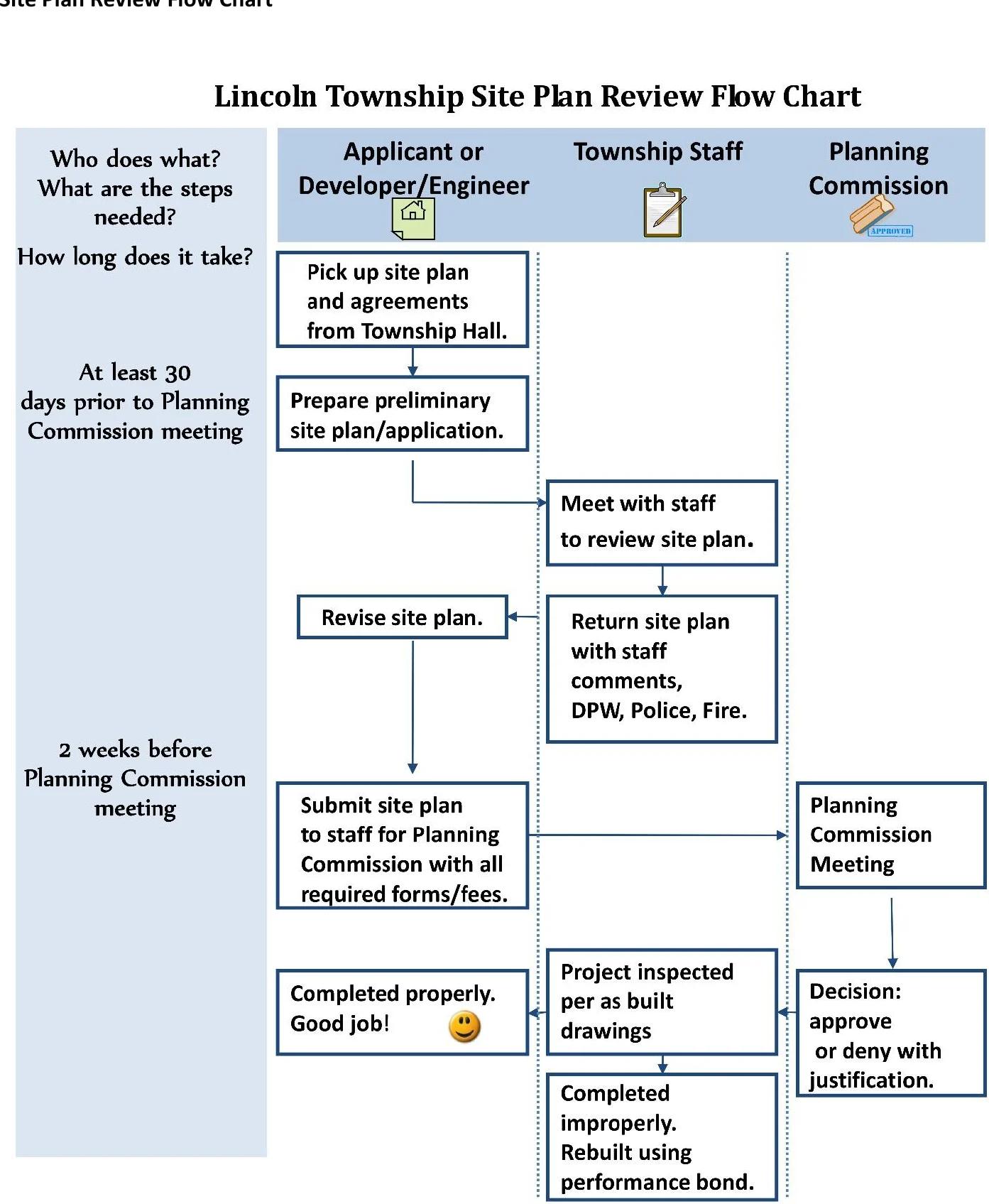 (opens the full-size diagram in a new tab)
Read a text description of this diagram
How to Submit a Special Use Permit Request
A Special Use Permit is required for all uses listed as allowed by Special Use Permit in each zoning district. A permit may only be applied for to establish a use that is allowed by special use permit in a specified district. A Special Use permit is discretionary in nature. A Special Use must first meet the guidelines established for that use in the Zoning Ordinance. Additional requirements may be imposed by the Planning Commission during the review of the permit, depending on the specific circumstances surrounding the proposal. A special use permit requires a public hearing.
Material to submit
- The Township will supply you with a Special Use Permit Application form and Site Plan Review Application form. Please fill each form out completely.
- The following is a list of items each site plan must include - if they are applicable to your project. This list is called the Site Plan Review Checklist. It is helpful to provide this to your engineer or architect. The Planning Commission uses this checklist to review the plan so it is wise to follow this list.
- All site plans must be prepared and sealed by a licensed engineer, architect, landscape architect or surveyor.
- Ten (10) copies of each plan must be submitted, including (10) ten copies of elevation perspectives of any buildings to be constructed.
Time line for review
- A special use permit requires a public hearing. The notification for this hearing must be printed in the paper and sent to all property owners within 300' of the subject property. Application for a special use permit must be submitted four (4) weeks prior to the Planning Commission meeting. (Planning Commission Meetings are held at the Lincoln Township Hall, 1882 N. Hope Rd. Meetings begin at 6:30 PM.)
- All site plans must be delivered to the Township office 30 days prior to the date of the Planning Commission meeting. The Township’s planning consultant will contact you to discuss your site plan and suggest revisions prior to the meeting. Should you wish to remain on the agenda for that month’s meeting, revised plans must be submitted two (2) weeks prior to the meeting. Plans that require a longer period of time to revise will be considered at the next month’s meeting.
- Incomplete site plans will not be reviewed by the Planning Commission. It is our intent to provide you with an efficient review and approval of your plan. This can only be done if the plan is complete and prepared according to the Township’s ordinances and rules.
Fees
- The Township charges a fee of $325.00 for each special use permit. This includes the plan review fee, but no other professional fees for reviews requested by the Township or required by law. This fee pays for the cost of publishing the notice of public hearing and the professional review of your plan.
- If a drainage review or other professional opinion is necessary to review and/or approve your site plan, an estimate of fees will be provided to you prior to any reviews being conducted.
How the process works
- The Planning commission will receive a copy of your special use permit and site plan prior to the Planning Commission meeting.
- At the meeting you or your representative will be given an opportunity to present your plan. The Planning Consultant will comment on the plan, including any recommendations or conditions for approval.
- The Planning Commission will discuss the special use permit first to determine if the use is appropriate in the district. If the use is appropriate, the site plan will be considered. Approval of the special use permit is contingent upon approval of the site plan. The Planning Commission will then vote to approve, approve with conditions, deny or table the plan to a specified date, which is generally the next meeting.
- If your plan is tabled for incomplete information, you will have one (1) month to produce the necessary information and be reheard at the next Planning Commission meeting. After one (1) month, your site plan will be removed from the active business of the Planning commission for incomplete information. A new special use permit application, site plan and fee may be submitted at any time after that.
Application for Special Use Permit
(Must Be Submitted At Least Thirty (30) Days Prior To Meeting)
Completed Application must include all fees, a site plan application along with 10 full size copies and 1 reduced copy of site plan.
$325.00 Fee
- Applicant
- Blank
- Date
- Blank
- Address
- Blank
- Telephone
- Blank
- Fax
- Blank
- Applicants Signature
- Blank
- Owner (If different than applicant)
- Blank
- Address
- Blank
- Telephone
- Blank
- Fax
- Blank
- Owner's Signature
- Blank
- Subject Property Address
- Blank
- Legal Description
- Provide the legal description of the property affected - if additional space is needed please attach on a separate sheet to this application
- Blank
- Proposed Use(s)
- Blank
For Office Use Only:
- Date Filed
- Blank
- Amount Paid
- Blank
- Case #
- Blank
- Hearing Date
- Blank
- Current Zoning
- Blank
- Parcel ID No.
- Blank
Special Land Use Review Flow Chart
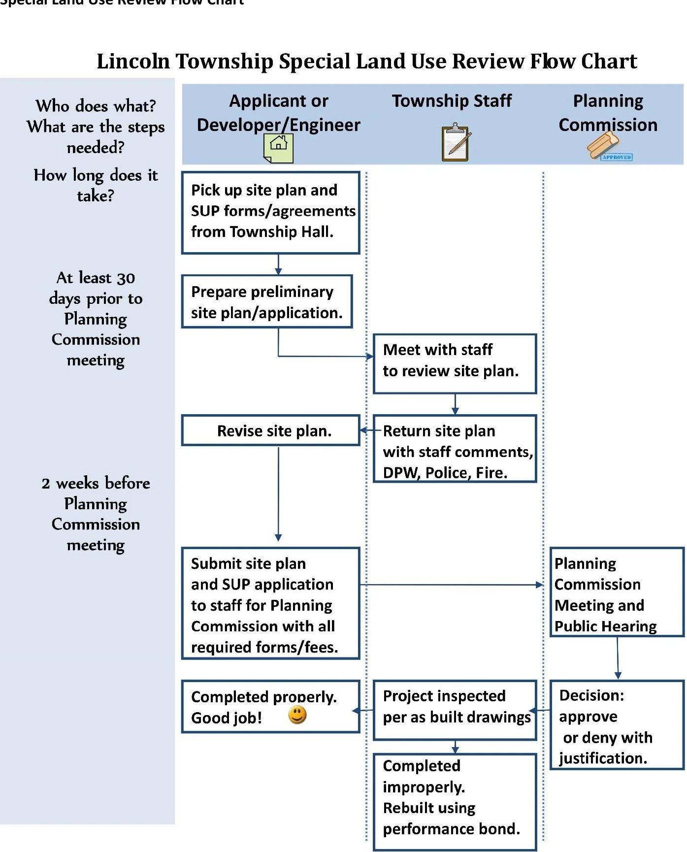 (opens the full-size diagram in a new tab)
Read a text description of this diagram
How to Submit a Rezoning Request
This is the process to request that the zoning classification for a parcel of property is changed or that the text of the zoning ordinance is changed. Only the property owner, the Planning Commission or the Township Board may initiate a change to the zoning classification of a parcel. Only the Township Board may approve a request to rezone property. A rezoning request requires a public hearing and notification of all property owners within 300' of the parcel.
Materials to submit
- The Township will supply you with a Rezoning Review Application form. Please fill the form out entirely.
- If you are requesting that the zoning classification is changed, a map of the location of the parcel with a legal description is required.
Time line for review
- A rezoning request requires a public hearing. The hearing must be advertised at least three weeks in advance of the hearing date. Following Planning Commission action at the Township level, the Midland County Planning Commission will review and provide comment on the request. With this information in hand, the Township Board will make the final decision regarding the rezoning. A rezoning typically takes three (3) months to complete.
- All applications and maps must be delivered to the Township Office four (4) weeks prior to the date of the Planning Commission meeting. (Planning Commission Meetings are held at the Lincoln Township Hall, 1882 N. Hope Rd. Meetings begin at 6:30 PM.)
- The Township’s planning consultant will contact you to discuss your request prior to the meeting. Should you wish to remain on the agenda for that month’s meeting, revised plans for parcels or text must be submitted by 4:30 PM two (2) weeks prior to the meeting. Plans that require a longer period of time to revise will be considered at the next month’s meeting.
- Incomplete text change requests or parcel information will not be reviewed by the Planning Commission. It is our intent to provide you with an efficient review and approval of your request. This can only be done if the information is complete and prepared according to the Township’s ordinances and rules.
Fees
The Township charges a fee of $550.00 for each rezoning request. This fee pays for the cost of professional review of your request and notification of a public hearing.
How the process works
- The Planning Commission will receive a copy of your request prior to the Planning Commission meeting.
- At the meeting you or your representative will be given an opportunity to present your plan. Planning Consultant will comment on the request, including any recommendations or conditions for approval.
- The Planning Commission will discuss the request and vote to recommend to the Township Board to approve, approve with conditions, deny or set aside the plan to a specified date, which is generally the next meeting.
If your request is tabled for incomplete information, you will have one (1) month to produce the necessary information and be reheard at another Planning Commission meeting. After one (1) month, your request will be removed from the active business of the Planning Commission for incomplete information.
Application for Rezoning
- Date
- Blank
- Property is currently zoned
- Blank
- Requesting to be rezoned to
- Blank
- Present Use
- Blank
- Proposed Use
- Blank
- Legal description of property requested to be rezoned
- Note: It is your responsibility to provide an accurate description of your request.
- Blank
Amount due for this request: $550.00
- Signature of Applicant
- Blank
- Address of Applicant
- Blank
- City
- Blank
- State
- Blank
- Zip
- Blank
- Phone Number (Home)
- Blank
- Phone Number (Work)
- Blank
Submit Application with Fee to: Lincoln Township Supervisor, 1882 N. Hope Road, Midland, MI 48640
For Office Use Only
- Fee and Application Received by Township Clerk Date
- Blank
- Application Received by Planning Chairperson Date
- Blank
Rezoning Flow Chart
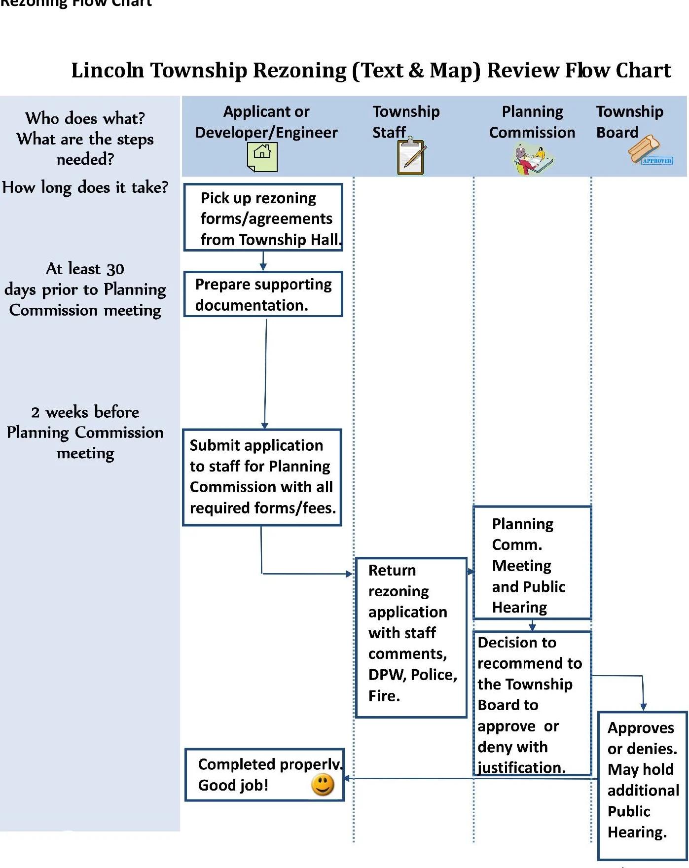 (opens the full-size diagram in a new tab)
Read a text description of this diagram
How to Submit a ZBA Request
(Zoning Board of Appeals)
This is the process to request a Variance Request, Ordinance or Map Interpretation of an Appeal from Administrative Decisions. The Zoning Board of Appeals Application must be filled out completely and returned no later than three (3) weeks prior to a scheduled Board of Appeals hearing. All mailings will be sent to the applicant.
Materials to submit
- The Township will supply you with a Zoning Board of Appeals Application form. Please fill the form out completely.
Time line for review
- Zoning Board of Appeals requires notification of all property owners within 300' of the property.
- Applicant will be notified as to when the Appeals meeting is scheduled.
Fees
The Township charges a fee of $325.00 for each Zoning Board of Appeals application. This fee pays for the cost of professional review of your request and notification to property owners.
Zoning Board of Appeals Application
Variance Request Application
- Date
- Blank
- Name
- Blank
- Address
- Blank
- Phone Number (Home)
- Blank
- Phone Number (Work)
- Blank
- Provide the legal description of the property affected
- Blank
- Tax Identification Number
- Blank
- Current Zoning of Property
- Blank
- Explain Variance Request
- (Use additional sheets if necessary)
- Blank
- Signature
- Blank
- Amount Enclosed
- Blank
Request Fee: $325.00. No action will be taken until the entire fee is submitted.
Return This Application with Fee to: Lincoln Township Supervisor 1882 N. Hope Road, Midland, MI 48640
For Office Use Only
- Received by Township Clerk
- (Date)
- Blank
- Received by Board of Appeals Chairman
- (Date)
- Blank
The Board of Appeals will use the following questions to help decide if a variance is necessary. The Board will ask the questions listed below:
Board of Appeals Checklist
(A variance will only be granted if all of the following questions are answered “yes” and practical difficulty with compliance to the zoning ordinances must be demonstrated.)
- 1)Has the Applicant shown that this variance would not adversely affect the intent and purpose of the Zoning Ordinance? If yes, explain.
- 2)Has the Applicant proven that a variance will not cause an adverse effect on adjacent properties?
- 3)Has the Applicant proven that a variance would not produce a nuisance condition to nearby premises?
- 4)Is the basis for the proposed variance due to uniquely identified characteristics of the property and not related to general conditions in the same zoning district throughout the Township? (If the Board of Appeals finds that the hardship is not unique, but common, then an amendment to the zoning ordinance or a re-zoning should be pursued.)
- 5)Has the Applicant shown that a variance will not otherwise impair the public health, safety, or general welfare of the residents of Lincoln Township?
- 6)Will strict compliance with the ordinances have the effect of unreasonably preventing the Applicant from using the property for a purpose permitted by the ordinance or would it be unnecessarily burdensome?
Flow Chart for Zoning Board of Appeals
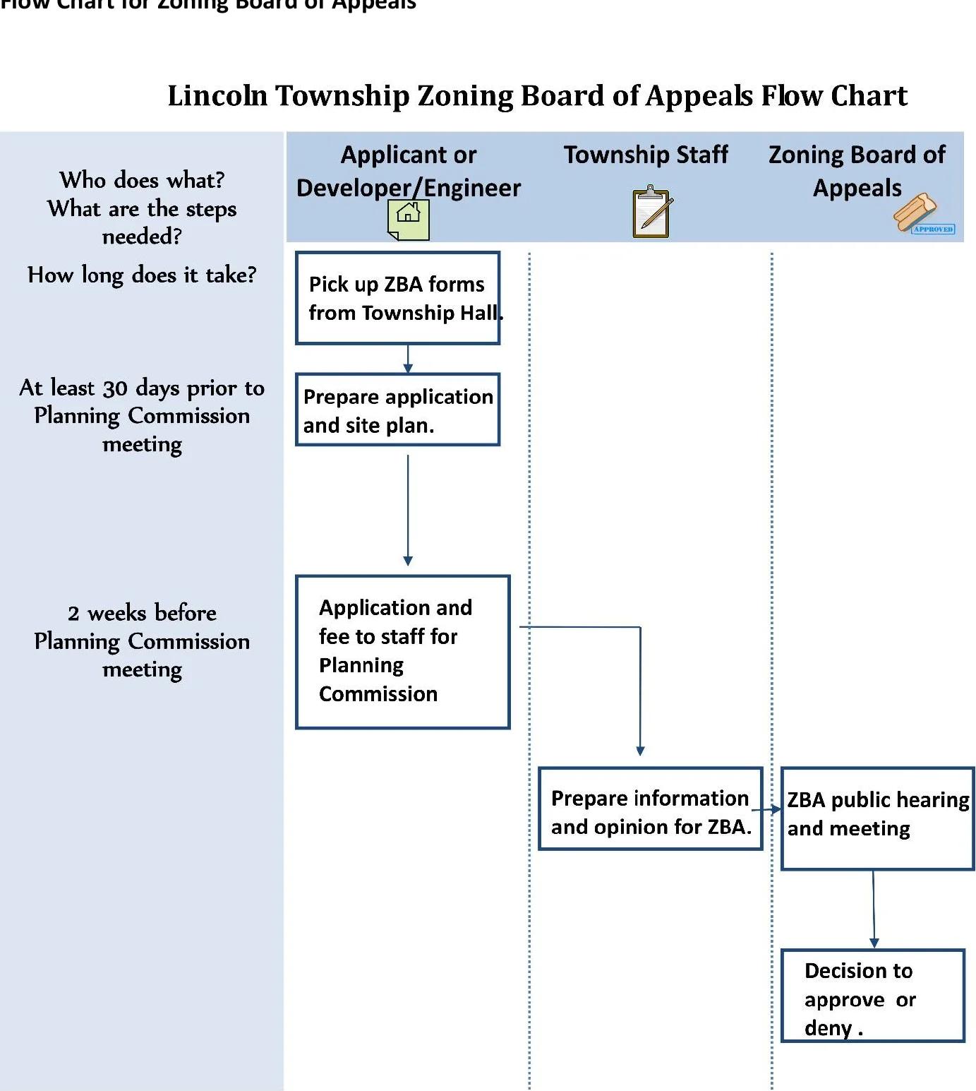 (opens the full-size diagram in a new tab)
Read a text description of this diagram
Master Plan Adoption/Amendment Flow Chart
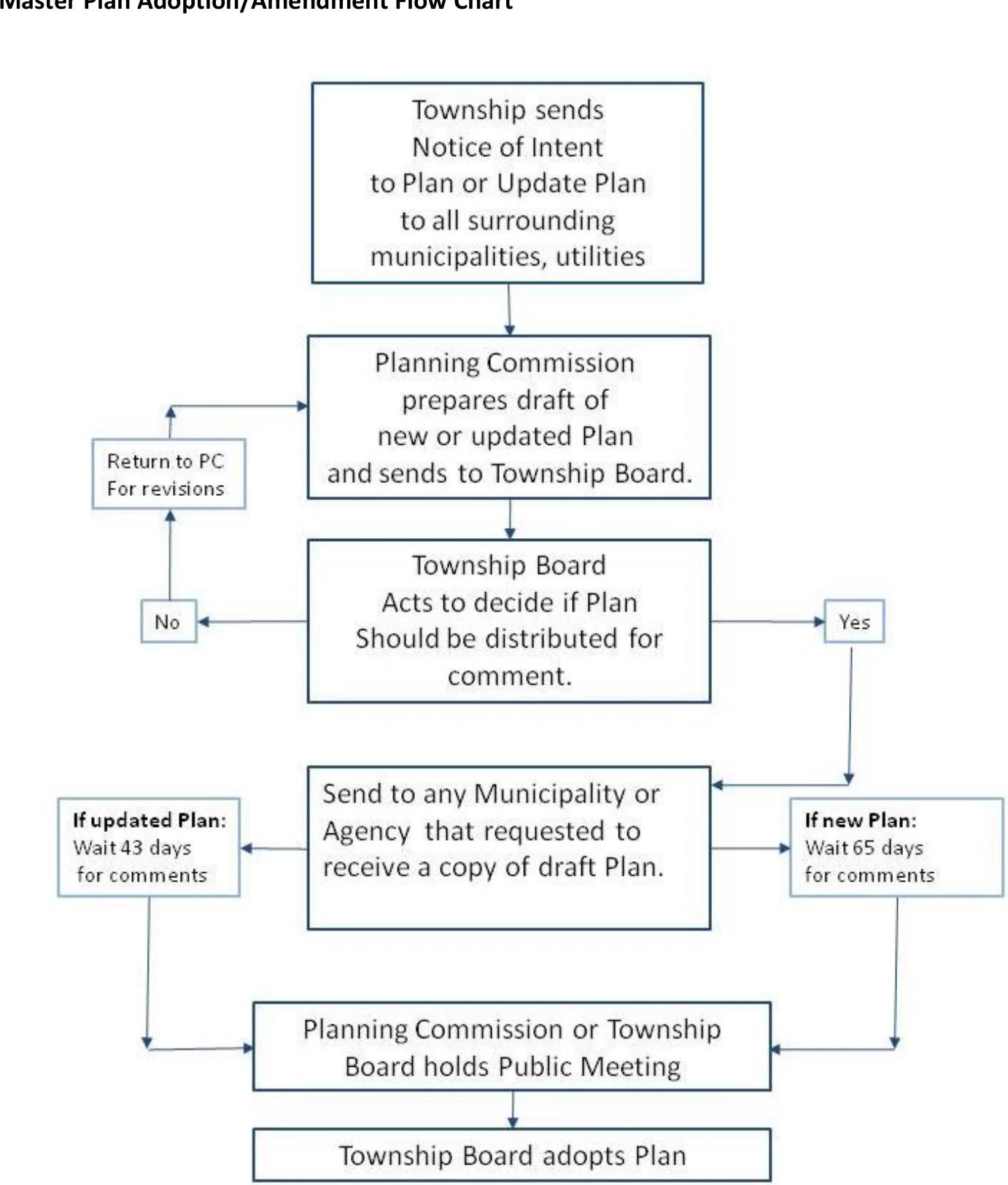 (opens the full-size diagram in a new tab)
Read a text description of this diagram
Publications
Requirements for Zoning Decisions
| Type of Action | Parties who may initiate | Body Making Decision | Public Hearing | Publication Requirements | Mail Notice to owners and occupants within 300’ & # of days before hearing | Body to which applicant may appeal a denial |
|---|---|---|---|---|---|---|
| VARIANCE | Property owner, agent or Administrator | ZBA | Yes | Once not less than 15 days | Once Not less than 15 days | Circuit Court only |
| INTERPRETATION | Property owner, agent or Administrator | ZBA | Yes | Once not less than 15 days | Once Not less than 15 days | Circuit Court only |
| APPEAL OF ADMINISTRATIVE DECISION | Any aggrieved party or State County or Twp. Officer board bureau or dept. | ZBA | Yes | Once not less than 15 days | Once Not less than 15 days | Circuit Court only |
| SITE PLAN | Property owner or agent | PC | No | Not required | Not required | PC after 1 year or Twp Board |
| SPECIAL USE PERMIT (SUP) | Property owner, agent or Administrator | PC | Yes | Once not less than 15 days | Once Not less than 15 days | PC after 1 year or Circuit Court |
| PLANNED UNIT DEVELOPMENT (PUD) | Property owner, agent or Administrator | PC | Yes | Once not less than 15 days | Once not less than 15 days | PC after 1 year or Circuit Court |
| Type of Action | Parties who may initiate | Body Making Decision | Public Hearing | Publication Requirements | Mail Notice to owners and occupants within 300’ & # of days before hearing | Body to which applicant may appeal a denial |
|---|---|---|---|---|---|---|
| REZONING (TEXT OR MAP CHANGE) | Property owner, agent or Administrator , Planning Commission or Township Board | PC recommends to Twp. Board | Yes | Once not less than 15 days | Once not less than 15 days | Planning Commission after 1 year |
| REZONING (TEXT OR MAP CHANGE) | Property owner, agent or Administrator , Planning Commission or Township Board | Township Board | If requested by any party | Once not less than 15 days | For map change: Individual property or 10 or fewer adjacent properties notify within 300 ft. for each property. If 11 or more adjacent properties notify within 300 feet of each property but no addresses of properties are required to be listed in notification. | Planning Commission after 1 year |
| MASTER PLAN OR MAP CHANGE | Public, Planning Commission or Township Board | Planning Commission Recommends to the Twp. Board | Yes | See PA 33 of 2008 | Not required. | Planning Commission |
| FEE WAIVER | Applicant | Township Board | No | Not Required | Not Required | Circuit Court |
What to publish before the public hearing:
- 1.Publish notice of the request in a newspaper of general circulation in the local unit of government.
- 2.Notice shall also be sent by mail or personal delivery to the owners of property for which approval is being considered. Notice shall also be sent to all persons to whom real property is assessed within 300 feet of the property and to the occupants of all structures within 300 feet of the property regardless of whether the property or occupant is located in the zoning jurisdiction.
- 3.The notice shall be given not less than 15 days before the date the application will be considered for approval. If the name of the occupant is not known, the term "occupant" may be used in making notification under this subsection. The notice shall do all of the following:
- a.Describe the nature of the request.
- b.Indicate the property that is the subject of the request. The notice shall include a listing of all existing street addresses within the property. Street addresses do not need to be created and listed if no such addresses currently exist within the property. If there are no street addresses, other means of identification may be used.
- c.State when and where the request will be considered.
- d.Indicate when and where written comments will be received concerning the request.
Whom to notify:
- 1.The legislative body of a local government may provide by ordinance for the manner in which the regulations and boundaries of districts or zones shall be determined and enforced or amended, supplemented, or changed. Amendments or supplements to the zoning ordinance shall be made in the same manner as provided under this act for the enactment of the original ordinance.
- 2.If an individual property or 10 or fewer adjacent properties are proposed for rezoning, the zoning commission shall give a notice of the proposed rezoning in the same manner as described above.
- 3.If 11 or more adjacent properties are proposed for rezoning, notice shall be given of the proposed rezoning in the same manner as described above, except that no individual addresses of properties are required to be listed.
What to publish after adoption of an amendment:
A zoning ordinance shall take effect upon the expiration of 7 days after publication as required by this section or at such later date after publication as may be specified by the legislative body.
- 1.Following adoption of a zoning ordinance and any subsequent amendments, the zoning ordinance or subsequent amendments a notice of ordinance adoption shall be published in a newspaper of general circulation in the local unit of government within 15 days after adoption.
- 2.The notice required under this section shall include all of the following information:
- a.In the case of a newly adopted zoning ordinance, the following statement: "A zoning ordinance regulating the development and use of land has been adopted by the legislative body of Lincoln Township.”
- b.In the case of an amendment to an existing zoning ordinance, either a summary of the regulatory effect of the amendment, including the geographic area affected, or the text of the amendment.
- c.The effective date of the ordinance or amendment.
- d.The place where and time when a copy of the ordinance or amendment may be purchased or inspected.
Public Hearing Notice for Zoning Amendment or Map Change
Public Hearing Notice to review amendments to the Lincoln Township Zoning Ordinance
A public hearing will be held to gather comments from the public regarding adoption of proposed revisions to the Township Zoning Ordinance.
If adopted, the proposed revisions will:
- Establish wind energy siting regulations,
- Establish regulations for the location of wood fired outdoor heaters,
- Increase the minimum lot size in the R-1 district to one acre for lots without sewer and water, and
- Increase the maximum size of accessory structures permitted on lots in the R-1 district that are greater than one acre.
A copy of the proposed revisions and a map showing the proposed new zoning district can be viewed at the Lincoln Township offices.
The hearing will be held on April 20, 2009 at 7:00 PM in the Lincoln Township Hall, located at 1882 N. Hope Rd., Midland, Michigan. Written comments will be received until 5:00 PM on Monday, April 20, 2009 and may be presented at the hearing.
Lincoln Township will provide necessary reasonable auxiliary aids and services to any individuals with disabilities who plan to attend this public meeting. Persons interested in such services need to contact the Lincoln Township Manager’s Office at 1882 N. Hope Rd. at least four (4) working days prior to the meeting. In the case of a special meeting where advance notice for accommodations is not possible, every reasonable effort will be made to accommodate the disabled.
This notice must be published once in a newspaper of general circulation not less than 15 days before the date of the public hearing.
Notice of Adoption of New Zoning Ordinance Text
At the DATE meeting of the Township Board of Trustees, two zoning ordinance amendments were approved. The amendments take effect seven days following this publication. A summary of the regulatory effect of the amendments is to:
- Amend Article xyx Z to regulate the height, placement and safety issues related to wind energy systems both for individual use and as part of a wind farm. Wind Energy Conversion Systems will be permitted by right in the Agricultural district if all structures associated with the system are 65 feet or less. Structures over 65 feet will be permitted by special use permit in the agricultural district only. Structures mounted on dwelling units shall be permitted in all districts provided they do not exceed the height or structural regulations for the district in which they are located.
- Amend Article xyx S to regulate the placement, fuels and safety issues related to outdoor wood fired heaters. Outdoor heaters will be permitted in the agricultural district by right and in the general and regional business districts by special use permit.
A copy of the revisions and entire zoning ordinance can be viewed or purchased at the Township offices located at ADDRESS between TIMES and DAYS. The ordinance is also available on the Township’s website, www.lincoln-twp.org.
This notice must be published once in a newspaper of general circulation not less than 15 days after adoption by the Township Board.
Public Hearing Notice for Master Plan Amendment or Map Change Text
A public hearing will be held to hear a request from the Township Planning Commission to revise the Future Land Use Plan map. Copies of the map are available for review at the Township Offices. .
The hearing will be held on DATE, at TIME in the Lincoln Township Hall, located at 1882 N. Hope Rd., Midland, Michigan. Written comments will be received until TIME on DATE and may be presented at the hearing.
Lincoln Township will provide necessary reasonable auxiliary aids and services to any individuals with disabilities who plan to attend this public meeting. Persons interested in such services need to contact the Lincoln Township Supervisor’s Office located at 1882 N. Hope Rd., Midland, Michigan at least four (4) working days prior to the meeting. In the case of a special meeting where advance notice for accommodations is not possible, every reasonable effort will be made to accommodate the disabled.
This notice must be published once in a newspaper of general circulation not less than 15 days prior to the public hearing on the Master Plan.
Notice of Intent to Plan Text
DATE
«AddressBlock»
Re: Lincoln Township Master Plan
Dear Sir/Madam:
On behalf of Lincoln Township, this letter comes to you to inform you that Lincoln is preparing a new Master Plan. In accordance with Planning Enabling Legislation PA 33 of 2008, this letter is to notify our neighboring local governments, utilities and any other related entities that have requested this notice, that Lincoln Township welcomes your cooperation and comments on the proposed plan. If you request a draft plan, the Township will send you an electronic copy of the proposed Master Plan as soon as the draft is completed.
Please contact me with any questions or concerns. Thanks very much.
Sincerely,
Signature line for NAME
Planner
Miscellaneous Forms
Citizen Complaint Form
- Date
- Blank
- Your Name
- Blank
- Address
- Blank
- Phone
- Blank
- Complaint
- (Provide specific details such as names, locations of complaint, dates, etc)
- Blank
- Action Requested
- Blank
- Complainant’s Signature
- Blank
Citizen Complaint Form (continued)
For Office Use Only
- Date Complaint Received
- Blank
- Received By
- Blank
- Comments
- Blank
- Date Inspector Received Complaint
- Blank
- Date Contact Was Made
- Blank
- Contact Made With
- Blank
- In Person
- By Phone
- Results
- Blank
- Inspection Made (Date)
- Blank
- Inspector’s Card Posted at Site (Date)
- Blank
- Pictures Taken (Date)
- Blank
- Violation Notice Sent (Date)
- Blank
- Violation Notice Posted (Date)
- Blank
- Date
- Blank
- Results
- Blank
Home Occupation Permit
Definition: A Home Occupation is an occupation for gain or support conducted solely by members of a family residing on the premises and conducted solely in the home or attached garage and not in accessory buildings.
- Description of proposed home occupation (activities or work to be conducted:
- Blank
- Names of all family members who will be working in Home Occupation:
- Blank
- Street Address of Home
- Blank
- House of Operation
- Blank
- Parking available
- Driveway
- Driveway and Pad
- On Street
- Other
- Other (parking)
- Blank
Approval of Home Occupation Permit:
- Ordinance Enforcement Officer
- Blank
- Date
- Blank
Note: If a sign will be used, a sign permit is required. You may obtain an application form from Lincoln Township Clerk. Signs for Home Occupations in Residential and Agriculture zones may not exceed 12 square feet in total area. Approval of Township Planning Commission is required before sign is installed.
Land Division Application
You MUST answer all questions and include all attachments, and include the application fee in the amount of $100.00 payable to Lincoln Township, or this will be returned to you. Bring or mail to: Lincoln Township Supervisor, 1882 N. Hope Rd., Midland, Michigan 48640.
Approval of a division of land is required before it is sold, when a new parcel is less than 40 acres and not just a property line adjustment.
This form is designed to comply with Sec. 108 and 109 of the Michigan Land Division Act (formerly the subdivision control act P.A. 288 of 1967 as amended (particularly by P.A. 591 of 1996 and P.A. 87 of 1997, MCI 560 et. seq.) (Approval of a division is not a determination that the resulting parcels comply with ordinances or regulations.)
- 1.LOCATION OF PARENT PARCEL to be split:
- Address
- Blank
- Road Name
- Blank
- PARENT PARCEL IDENTIFICATION NUMBER
- Blank
- Parent Parcel Legal Description (Describe or Attach)
- Blank
- 2.PROPERTY OWNER INFORMATION:
- Name
- Blank
- Address
- Blank
- Phone
- Blank
- 3.PROPOSED DIVISION(S) TO INCLUDE THE FOLLOWING:
- A. Number of new Parcels
- Blank
- B. Intended use (residential, commercial, etc.)
- Blank
- C. Each proposed parcel if 10 acres or less, has a depth to a width ratio of 4 to 1 or ___ to ___ as provided by ordinance.
- Blank
- D. Each parcel has a width of
- (not less than required by ordinance).
- Blank
- E. Each parcel has an area of
- (not less than required by ordinance).
- Blank
- F. The division of each parcel provides access as follows:
- Blank
- G. Describe or attach a legal description of proposed new road, easement or shared driveway:
- Blank
- H. Describe or attach a legal description for each proposed new parcel:
- Blank
- 4.FUTURE DIVISIONS being transferred from the parent parcel to another parcel. Indicate number transferred ____________ (See Sec 109 (2) of the Statute. Make sure your deed includes both statements as required in 109 (3 and 4) of the Statute.)
- 5.DEVELOPMENT SIZE LIMITS (Check each which represents a condition which exists on the parent parcel):
- Development size limits
- Waterfront property (river, lake, pond, etc.)
- Is within a flood plain
- Is on muck soils or soils known to have severe limitations for onsite sewage system
- Includes wetlands
- Includes a beach
- 6.ATTACHMENTS – All the following attachments MUST be included. Letter each attachment as shown:
- A.A scale drawing that complies with the requirements of PA 132 of 1970 as amended for the proposed division(s) of the parent parcel showing:
- 1.current boundaries (as of March 31, 1997), and
- 2.all previous divisions made after March 31, 1997 (indicate when made or none), and
- 3.the proposed division(s) and
- 4.dimensions of the proposed divisions, and
- 5.existing public utility facilities, and
- 6.easement for public utilities from each parcel that is a development site to existing public utility facilities, and
- 7.any existing improvements (buildings, wells, septic system, driveways, etc.)
- 8.any of the features checked in Questions Number 5.
- B.Indication of approval or permit from Midland County Road Commission that a proposed easement provides vehicular access to an existing road or street meets applicable location standards.
- C.A copy of any reserved division rights (Sec 109 (4) of the Act) in the parent parcel.
- A.A scale drawing that complies with the requirements of PA 132 of 1970 as amended for the proposed division(s) of the parent parcel showing:
- 7.IMPROVEMENTS – Describe any existing improvements (buildings, wells, septic, etc., which are on the parent parcel or indicate none).
- Existing improvements
- Blank
- 8.AFFIDAVIT and permission for township, county and state officials to enter property for inspections: I agree that the statements made above are true, and if found not to be true this application and any
approval will be void. Further, I agree to comply with the conditions and regulations provided with this parent parcel division. Further, I agree to give permission for officials of the township, county and State of Michigan to enter the property where this parcel division is proposed for purposes of inspection. Finally, I understand this is only a parcel division which conveys only certain rights under the applicable local land division ordinance and the State Land Division Act (formerly the Subdivision Control Act PA 288 of 1967, as amended (particularly by PA 591 of 1996 and PA 87 of 1997, MCL 560.101 et. Seq.) and does not include any representation or conveyances of rights in any other statute, building code, zoning ordinance, deed restrictions or other property rights.
Finally, even if this division is approved, I understand local ordinances and state Acts change from time to time and, if changed, the divisions made here must comply with the new requirements (apply for division approval again) unless deeds representing the approved divisions are recorded with the Register of Deeds or the division is built upon before the changes to laws are made.
- Property Owner’s Signature
- Blank
- Date
- Blank
For Office Use Only
- Reviewer’s action: Total Fee $
- Blank
- Check #
- Blank
- Signature
- Blank
- Application Completed Date
- Blank
- Approval Date
- Blank
- Denial Date
- Blank
- Reasons for denial
- See Attached
- Blank
Mining Mineral Site Application
- Name of Applicant (proposed licensee)
- Blank
- Address
- Blank
- City
- Blank
- State
- Blank
- Zip Code
- Blank
- Phone
- Blank
- Blank
- Owners of Land
- Blank
- Address
- Blank
- City
- Blank
- State
- Blank
- Zip Code
- Blank
- Phone
- Blank
- Blank
- Name of Company Conducting Actual Removal
- Blank
- Address
- Blank
- City
- Blank
- State
- Blank
- Zip Code
- Blank
- Phone
- Blank
- Blank
- Location of Land
- Blank
- Section
- Lincoln Township, Midland County, Michigan
- Blank
- Size of Land
- Blank
- Legal Description of Land
- Blank
- Type of material or resources to be mined, stockpiled, or hauled away
- Blank
- Estimated number of years to complete mining operations
- Blank
- Number of phases of Mining operations
- Blank
- Description of types of equipment to be used
- Blank
- Proposed method of removal and general haul route
- Blank
Documents Required:
- I.Plan of operations, which must include:
- A.Drawing of existing parcel drawn to a scale of 1 inch = 100 feet, clearly showing:
- 1.Area to be mined
- 2.Existing areas and roads within 100 feet of all property lines, and
- 3.Areas for stockpiling, maintenance areas, berms, fencing, and similar use areas.
- B.The following specific dates:
- 1.Commencement and completion of mining operations as provided by the plan of operation
- 2.Commencement and completion of erosion and draining control measures to be instituted during mining operation, and
- 3.Commencement and completion of fencing, roads, utilities, or any other structure or improvements to be located on the site as provided by the plan of operations.
- A.Drawing of existing parcel drawn to a scale of 1 inch = 100 feet, clearly showing:
- II.Plan of reclamation, which must include
- A.An estimate of the cost of reclamation
- B.The area of completely reclaimed land
- C.The area of reclamation presently under way
- D.The area used for topsoil and overburden storage
- E.The acreage for items B-E shown on an overlay or separate drawing
- F.A description of the methods and materials proposed for restoration of topsoil to the required fertility and the amount of any type of planting as a part of the reclamation plan
- G.The projected schedule of reclamation operations, including the following specific dates:
- 1.Commencement and completion of reclamation operations as provided by the reclamation plan
- 2.Commencement and completion of erosion and drainage control measures to be instituted under the reclamation plan, and
- 3.Commencement and completion of final grading, topsoil replacement, and replanting or landscaping as provided by the reclamation plan.
Applicant (proposed licensee)\*
- Signed
- Blank
- Dated
- Blank
- Print name
- Blank
Owner (of land)\*
- Signed
- Blank
- Dated
- Blank
- Print name
- Blank
Operator (or operating company)\*
- Signed
- Blank
- Dated
- Blank
- Print name
- Blank
*Note: application must be signed by applicant, owner and operator.
Mutual Access Agreement
Lincoln Township Mutual Access Easement Agreement
By and Between: Lincoln Township &
- Name (Parcel A)
- Blank
- Parcel # (Parcel A) and
- Blank
- Name (Parcel B)
- Blank
- Parcel # (Parcel B),
- Blank
- Name (Parcel C)
- Blank
- Parcel # (Parcel C),
- Blank
- Name (Parcel D)
- Blank
- Parcel # (Parcel D).
- Blank
This agreement is made and entered into this _____ day of __________, 2010 by and between Lincoln Township and _________________________.
WHEREAS, (insert land owner) is the current owner and interest holder of the property legally described as (insert legal description), henceforth referred to as “Parcel A”; and (insert land owner) is the current holder and interest holder of the property legally described as (insert legal description), henceforth referred to as “Parcel B”, and (insert land owner) is the current holder and interest holder of the property legally described as (insert legal description), henceforth referred to as “Parcel C”, and (insert land owner) is the current holder and interest holder of the property legally described as (insert legal description), henceforth referred to as “Parcel D”,
WHEREAS, The Lincoln Township Zoning Ordinance mandates, where possible, the establishment of shared driveways, parking lot connections and other cross access arrangements for properties in the Commercial and Industrial zoning districts of the Township,
WHEREAS, It has been stipulated by the Lincoln Township Planning Commission and the Michigan Department of Transportation, in approving the preliminary site plan for _____________________ that it is necessary to establish a shared driveway between Parcel A and Parcel B and access to Parcels C and D from this shared driveway, in order to facilitate efficient traffic operations and improve public safety in this location, now
THEREFORE, In consideration of the foregoing and the terms and conditions contained herein, the above named parties agree as follows:
- 1.Access Easement
- a.An easement shall be created which shall allow the above named parties and the general public vehicular and pedestrian access across Parcel A, Parcel B, Parcel C and Parcel D. This easement is illustrated on the attached Exhibit A, and legally described as follows: (insert legal description)
- b.No physical barrier including, but not limited to, curbs, structures, buildings, signs, parking spaces, and product displays shall be placed across the easement in such a manner as to block access across and/or between Parcel A, Parcel B, Parcel C and/or Parcel D.
- c.Details pertaining to the placement of the access drive within the easement shall be illustrated on the final site plans for any future developments on Parcel A, Parcel B, Parcel C and/or Parcel D, or any portions thereof. Said plans shall be submitted to the ______________ Planning Commission for review and approval.
- d.Properties located adjacent to the easement shall be permitted to connect their parking areas, aisle ways, driveways, etc. to the access drive within the easement. The easement and corresponding access drive shall be open for use by the general public.
- e.The easement shall be permanently recorded with the Midland County Register of Deeds.
- 2.The owners of Parcel A, Parcel B, Parcel C and Parcel D hereby covenant and agree that this agreement shall be binding and shall inure to the benefit of the parties hereto, their successors, assigns, tenants, and subtenants, and that the covenants herein contained shall be deemed to be covenants running with the land.
- 3.________________ shall be responsible for the payment of any and all costs and expenses incurred and arising out of any use of the easement for any of the purposes described and set forth in this agreement including, but not limited to, any cost and expenses incurred in the construction, maintenance and repair of the pavement within that portion of the easement area located on Parcel _____.
________________ shall be responsible for the payment of any and all costs and expenses incurred and arising out of any use of the easement for any of the purposes described and set forth in this agreement including, but not limited to, any cost and expenses incurred in the construction, maintenance and repair of the pavement within that portion of the easement area located on Parcel ____.
- 4.________________ and ______________ shall be responsible for the payment of any and all costs and expenses incurred and arising out of the initial construction of the access drive within that portion of the easement area located on Parcel ____. ________________ and ________________ shall each pay one-half ( ) of the costs and expenses of construction of said access drive. ________________ shall construct said access drive within the easement (describe location) concurrent with the construction of the __________________. _______________ shall reimburse __________________ for its portion of the costs of construction upon completion of said access drive on Parcel ____. *(modify as appropriate).
- 5.Each party shall separately operate the easement area located on their respective parcels and shall maintain the same in good condition and repair at their own cost and expense so long as such easement area shall exist.
IN WITNESS WHEREOF, _____________________ and _____________________ the ___________________ and _____________________, respectively, of _________________ (owner A) have hereunto set their hands on the date affixed hereto.
- Witnessed by: (owner A)
- Blank
- Date
- Blank
- Title
- Blank
- Date
- Blank
- Date
- Blank
- Title
- Blank
- Date
- Blank
STATE OF Michigan
COUNTY OF Midland
On this _______ day of _______________, 2001 before me personally appeared _____________ and _____________ the _____________ and _____________, respectively, of ___________________(owner A) to me known as the persons who executed the foregoing instrument and acknowledge the same to be their own free act and deed.
- Notary Public, County
- Blank
- Acting In County
- Blank
- My Commission Expires
- Blank
IN WITNESS WHEREOF, _____________________ and _____________________ the ___________________ and _____________________, respectively, of _________________ (owner B) have hereunto set their hands on the date affixed hereto.
- Witnessed by: (owner B)
- Blank
- Date
- Blank
- Title
- Blank
- Date
- Blank
- Date
- Blank
- Title
- Blank
- Date
- Blank
STATE OF Michigan
COUNTY OF Midland
On this _______day of _______________, 2001 before me personally appeared _____________ and _____________ the _____________ and _____________, respectively, of ___________________(owner B) to me known as the persons who executed the foregoing instrument and acknowledge the same to be their own free act and deed.
- Notary Public, County
- Blank
- Acting In County
- Blank
- My Commission Expires
- Blank
IN WITNESS WHEREOF, _____________________ and _____________________ the ___________________ and _____________________, respectively, of _________________ (owner C) have hereunto set their hands on the date affixed hereto.
- Witnessed by: (owner C)
- Blank
- Date
- Blank
- Title
- Blank
- Date
- Blank
- Date
- Blank
- Title
- Blank
- Date
- Blank
STATE OF Michigan
COUNTY OF Midland
On this _______day of _______________, 2001 before me personally appeared _____________ and _____________ the _____________ and _____________, respectively, of ___________________(owner C) to me known as the persons who executed the foregoing instrument and acknowledge the same to be their own free act and deed.
- Notary Public, County
- Blank
- Acting In County
- Blank
- My Commission Expires
- Blank
IN WITNESS WHEREOF, _____________________ and _____________________ the ___________________ and _____________________, respectively, of _________________ (owner D) have hereunto set their hands on the date affixed hereto.
- Witnessed by: (owner D)
- Blank
- Date
- Blank
- Title
- Blank
- Date
- Blank
- Date
- Blank
- Title
- Blank
- Date
- Blank
STATE OF Michigan
COUNTY OF Midland
On this _______day of _______________, 2001 before me personally appeared _____________ and _____________ the _____________ and _____________, respectively, of ___________________(owner D) to me known as the persons who executed the foregoing instrument and acknowledge the same to be their own free act and deed.
- Notary Public, County
- Blank
- Acting In County
- Blank
- My Commission Expires
- Blank
Occupancy Permit
This permit application is for the occupancy of existing premises at the listed location for the purpose of conducting or operating a business for which a permit is required by local ordinance. This permit application shall be filed with the Fire Prevention Division prior to occupancy. A $100.00 application fee is to be paid upon submittal of this application. Make check or money order payable to Lincoln Township. The approved permit is not transferable and shall expire upon a change in occupancy.
- Application Date
- Blank
- Intended Occupancy Date
- Blank
- Business Name
- Blank
- Address of where business will occur
- Blank
- Applicant Name / Contact Person
- Blank
- Applicant Address
- Blank
- Phone
- Blank
- Type of Occupancy and/or Business
- Blank
- Area of space to be occupied (square feet)
- Blank
- Description of inventory materials and/or processes
- Blank
I hereby acknowledge that I have read this permit application and that the information given is correct. I understand that I may be required to provide further information upon request. I further understand that if approved, the permit is non-transferable, and the permit application fee of $100.00 is non-refundable and therefore will not be returned if the permit is denied.
- Applicant signature
- Blank
(To be completed by Fire Department)
- Inspection Date
- Blank
- Fire Protection
- Yes
- No
- Inspector
- Blank
- HMIS Required
- Yes
- No
- Premise #
- Blank
- Permit Approved
- Yes
- No
- Use Group
- Blank
- Floor Area
- Blank
- Stipulations
- Blank
Sign Permit Application – Version A
Signs erected in Lincoln Township after April 2, 1997 must be in compliance with Ordinance Nos. amended by Ordinance No. which regulate the construction, size and placement of signs in the Township. Copies of these Ordinances may be obtained from the Lincoln Township Clerk.
Please complete all information requested below and submit this application to the Township Clerk who will schedule an official review at the next regularly scheduled meeting of the Planning Commission. A check for a minimum of $100.00, payable to Lincoln Township, must accompany the application form.
Review and approval must be obtained before sign is erected on the premises.
- Name
- Blank
- Mailing Address
- Blank
- City
- Blank
- State
- Blank
- Zip Code
- Blank
- Phone
- Blank
- Blank
- Property Tax Code for Location of Sign
- Blank
- Owner of Property (if different from above)
- Blank
Please attach written permission of the property owner if sign will not be located on the same premises as the business it is advertising.
- Size of Sign
- (All measurements should be in feet/inches)
- Blank
- Height
- (All measurements should be in feet/inches)
- Blank
- Width
- (All measurements should be in feet/inches)
- Blank
- Will sign be printed
- One side only
- Both Sides
- Construction Materials to be used
- (Please include all major components)
- Blank
- Colors
- Blank
Please attach a sketch of the proposed sign indicating the placement of any lettering and/or illustrations that will be used. Please indicate dimensions (Height/Width) of the sign itself as well as the height and placement of any posts or support materials. If the sign is to be used in a commercial or industrial zone a sketch showing the placement of the sign on the site and landscaping plans for the base of the sign must also be attached to this document. The sketch must also show placement of the sign on the property relative to property lines and right of way.
Any required electrical or construction permits must be submitted with this application.
TO BE COMPLETED BY TOWNSHIP PLANNING COMMISSION:
- Application fee paid
- Yes
- No
- Sign Approved
- Yes
- No
- Date
- Blank
- By: Chairman, Planning Commission
- Blank
- Inspection Approved
- Yes
- No
- Date
- Blank
- By: Ordinance Enforcement Officer
- Blank
Sign Permit Application – Version B
To be completed by Sign Owner
- Project name
- Blank
- Project explanation
- Blank
- Location
- Blank
- Parcel No
- Blank
- Address
- Blank
- City
- Blank
- State
- Blank
- Zip Code
- Blank
- Phone
- Blank
- Blank
- Print Sign Owner Name
- Blank
- Signature of Sign Owner
- Blank
- date
- Blank
To be completed by Installer
- Name of Installer
- Blank
- Address
- Blank
- City
- Blank
- State
- Blank
- Zip Code
- Blank
- Phone
- Blank
- Blank
- Print Contact Person Name
- Blank
- Signature of Contact Person for Installer
- Blank
- date
- Blank
To be completed by Parcel Owner
- Parcel Owner Name
- Blank
- Parcel Owner Address
- Blank
- City
- Blank
- State
- Blank
- Zip Code
- Blank
- Parcel Owner Phone
- Blank
- Blank
- Print Parcel Owner Name
- Blank
- Signature of Parcel Owner
- Blank
- date
- Blank
The following items must be attached to this application when submitted or it will not be reviewed:
- A front profile drawing having a scale of ¼ inch to 1 foot or greater from grade to the top of the sign excluding text or pictures
- A plot of the site showing the location and dimensions of the sign in relation to property lines, road right-of-way, parking spaces, driveways, sidewalks and building, as well as the location of any existing pole or ground signs on the parcel including billboards. All existing sign sizes shall be indicated.
- A lighting diagram shall be provided indicating the type of lighting proposed for the sign.
- Along with the building plans a footing plan must be submitted showing the footing depth and size meeting the standards found in the Michigan Building Code which is incorporated herein by reference.
- The building plans must include structural plan showing structural members and fasteners meeting the standards found in the Michigan Building Code.
- A filled out building permit application must be filled out and attached.
The following must be completed by the applicant or parcel owner:
- The road or highway right-of-way must be clearly marked in front of the proposed sign for inspection reasons. The leading edge of a pole or ground signs must be no closer than 10 feet to any road right-of-way.
- The right-of-way must be marked during both footing inspection and during final inspection.
By signing this application, I acknowledge that I have read and understand all requirements of the Township Sign Ordinance that must be followed in order to secure a permit to install the requested sign(s). I agree to follow all provisions of the Township Sign Ordinance related to sign installation including sign placement, location on the parcel, setbacks from side property lines as well as the setback from ant road or highway right-of-way. I agree to follow and understand fully all sunset provisions which require all pole, ground, and wall signage on the parcel to be brought into total compliance with the Township Sign Ordinance by DATE. I take full responsibility for providing true and accurate information and for marking the road or highway right-of-way. I attest to the fact that the plot plan provided to the Township Building Inspector shows the true road or highway right-of-way location and that the proposed sign will be installed as requested and will be set back a minimum of 10 feet from any road or highway right-of-way. I attest that I understand that I may replace the face or faces of the signs and this change does not bring them into compliance with the Township Sign Ordinance. I further attest that I was given a copy of the sign ordinance and have read and understood all provisions and requirements completely and agree to abide by the same.
Required Signatures
- Signature of Sign Owner
- Blank
- date
- Blank
- Signature of Installer
- Blank
- date
- Blank
- Signature of Parcel Owner
- Blank
- date
- Blank
The items listed below are to determine if a ground or pole sign placement is in compliance with the code and sign ordinance. The drawing will be checked by the Building Inspector for compliance and it is necessary to show all of the items listed below to complete the review process. If any of the items are not included on your drawing it will be denied a permit for insufficient information.
Must show on drawing:
- Building
- Driveway with distance to sign.
- Parking lot and distance from sign
- Parking spaces
- Pole or ground sign
- The distance from the side property line to the sign (must be a minimum of 10 feet)
- The distance from between the sign and the right-of-way (must be minimum of 10 feet)
Special Use Permit -Colocation – Attached Wireless Communication Facilities Application
- Name of Applicant
- Blank
- Mailing Address
- Blank
- City
- Blank
- State
- Blank
- Zip Code
- Blank
- Telephone No.
- Blank
- Owner(s) of Land
- Blank
- Mailing Address
- Blank
- City
- Blank
- State
- Blank
- Zip Code
- Blank
- Telephone No.
- Blank
- Owner(s) of Existing Facility, Tower, Building or Structure
- Blank
- Mailing Address
- Blank
- City
- Blank
- State
- Blank
- Zip Code
- Blank
- Telephone No.
- Blank
- If existing Wireless Communication Facility is there a Special Use Permit granted for same
- Yes
- No
- Date or number of Special Use Permit
- Blank
- If no Special Use Permit, explain reason no permit
- Blank
- Property address: Section ____, Lincoln Township, Midland County, Michigan
- Blank
- Legal Description of Property if no existing Special Use Permit
- Blank
THE FOLLOWING MUST BE PROVIDED TO COMPLETE THIS APPLICATION:
- 1.Site Plan of the property showing the existing and proposed location of all buildings and structures thereon, types thereof and their uses.
- 2.A statement and supporting data, exhibits, information and evidence regarding the following:
- a.That the proposed collocation or Attached Wireless Communication Facility will be designed, constructed, operated, maintained and managed so as to be compatible in appearance and use with the existing or intended adjacent uses of land;
- b.That the proposed collocation or Attached Wireless Communication Facility will not be hazardous or disturbing to existing or future neighboring uses; and
- c.That the proposed collocation or Attached Wireless Communication Facility will not interfere service provided by other Wireless Communication Facilities on the same property or elsewhere; and
- d.That the proposed collocation or Attached Wireless Communication Facility will not create excessive additional requirements at public cost for public facilities, utilities and services;
- 3.Signed certification by a State of Michigan licensed professional engineer with regard to the manner in which the proposed collocation or Attached Wireless Communication Facility equipment is to be attached to existing Facility, tower, building or structure, which certification shall provide that the collocation or Attached Wireless Communication Facility will not increase the loads or stresses on such existing structures beyond their capacity or increase the likelihood of instability, collapse or falling.
- 4.Execution and joinder in this Application by the Owner(s) of the Land and by the Owner(s) of Existing Facility, Tower, Building or Structure, by which those Owners hereby agree to this Application and to be bound by the Special Use Permit if granted.
- Date
- Blank
- Applicant Signature
- Blank
- Date
- Blank
- Property Owner Signature
- Blank
- Date
- Blank
- Existing Facility, Tower, Builder or Structure Owner
- Blank
Zoning Board of Appeals Final Decision and Form Minutes
- Appeal Number
- Blank
- Hearing Date
- Blank
- Applicant Name
- Blank
- Phone
- Blank
- Address
- Blank
- Marital Status
- Blank
- Reason for Request
- Blank
- Type of Appeal
- Interpretation
- Variance
- ZBA Findings of Fact
- Blank
- ZBA Determination
- Blank
- Reasons for Determination
- Blank
Vote of Board Members and signature:
- (Yes) (No) _____________________________________________
- (Yes) (No) _____________________________________________
- (Yes) (No) _____________________________________________
- (Yes) (No) _____________________________________________
- (Yes) (No) _____________________________________________
I, _____________________________, certify that on this date I witnessed the signatures set forth above and attest to the accuracy of this report.
- Dated
- Blank
- Secretary
- Blank
PLEASE NOTE THAT ANY APPEAL OF THIS DECISION MUST BE MADE TO A COURT OF PROPER JURISDICTION WITHIN 21 DAYS OF THE DATE OF THIS DECISION.
Zoning Compliance Permit
To be filled out in entirety by Applicant
LINCOLN TOWNSHIP ZONING COMPLIANCE PERMIT
Worksheet
Midland County, Michigan
- Application No.
- Blank
- Applicant Name
- Blank
- Address
- Blank
- Phone
- Blank
Owner of property involved
- Name
- Blank
- Address
- Blank
- Phone
- Blank
- Is applicant acting as Agent of property owner
- Yes
- No
- Address of property involved
- Blank
- Legal description of property involved or tax I.D. number
- Blank
- State what is to be built, remodeled, altered, etc.
- (include dimensions for each structure i.e. garage, house, deck, porch, pole barn; include number of floors and basement)
- Blank
- Total Value of project
- Blank
- Present zoning district
- (Commercial, Residential …)
- Blank
- Type of Building and land use
- Blank
- Description of lot: lot depth
- Blank
- lot width
- Blank
- Lot area (acres/sq. ft.)
- Blank
- Is a lake, river or stream within 500 ft. of property
- Yes
- No
- Access: Property is served by
- \*Access has to be improved to current standards as given in Ordinance
- Private road\*
- Public road\*
ZONING DISTRICT SETBACK AND AREA REQUIREMENTS MUST BE FILLED IN
Minimum Required Actual
- Lot area
- Blank
- Side yards from property line
- Blank
- Backyard from property line
- Blank
- Road right of way if waterfront
- Blank
- Front yard: From road right of way/From edge of water
- Blank
- Septic tanks from water 100 ft.
- Blank
- Drain fields or dry well from water 100 ft.
- Blank
- Lot Coverage (impervious material/structure/paving)
- (Maximum 35%coverage )
- Blank
- Building height-stories
- Blank
- or feet
- Blank
- Distance between buildings
- feet.(Either attached or at least 10 feet)
- Blank
- Is off-street parking proposed?
- Yes
- No
- Estimated construction start date
- Blank
MOBILE HOMES:
Mobile homes located outside of a licensed Mobile Home Park are required to have cement, cement block, brick or treated wood foundations (2"x4" top and bottom, 16" centers, 5/8" front) around entire perimeter of mobile home. Homes must have a minimum width of 24' for entire width of home. Homes must have 1200 sq ft of living area.
Mobile Home:
- Make
- Blank
- Model
- Blank
- Year
- Blank
- Serial Number
- Blank
- Outside dimensions
- ____ x ____
- Blank
The undersigned hereby agrees to comply with all ordinances and regulations of Lincoln Township, Midland County, Michigan and of any other agencies or governmental units which may be involved. Applicant signature hereon grants permission for township zoning official inspections as required to assure compliance with permit granted.
I/we do hereby swear that the above information is true and correct to the best of my/our knowledge.
- Date
- Blank
- Applicants
- Blank
- Approval or denial is for a term of 12 months
- Blank
- Date
- Blank
- Zoning Administrator
- Blank
When completed, the dwelling will have the following overall:
- Ground floor area
- Blank
- Chimney
- Blank
- Patio, sq. ft.
- Blank
- Number full baths
- Blank
- Inside or outside Enc. Porches
- ____X____
- Blank
- Number part baths
- Blank
- Hearths
- Blank
- Open Porches
- ____X____
- Blank
- Bedrooms
- Blank
- Wood burner
- Blank
- Decks, sq. ft.
- Blank
- Fin. Basement area
- Blank
- Air Cond.
- Blank
- Outbuildings
- ____X____
- Blank
- Heat Pump
- Blank
- Drive, cement
- Blank
- Asphalt
- Blank
Approval is contingent upon receipt of the following permits/approvals if applicable:
- Building Permit; Soil & Erosion Permit; Health Dept.; DNR
Worksheet and copy of plans-to be attached to permit
Appendix – Links
Michigan Legislative Links:
Michigan Adult Foster Care Facility Licensing Act, 1979 PA 218, MCL 400.701 to 400.737.
http://www.legislature.mi.gov/(S(e1aa1s45lvhfvsmt33hoklux))/mileg.aspx?page=getObject&objectname=mcl-act-218-of-1979)/mileg.aspx?page=getObject&objectname=mcl-act-218-of-1979)
Michigan Charter Township Act, Act 359 of the Michigan Public Acts of 1947
http://www.legislature.mi.gov/(S(m3xc3fzicplywz55vudz2nj3))/mileg.aspx?page=GetObject&objectname=mcl-Act-359-of-1947)/mileg.aspx?page=GetObject&objectname=mcl-Act-359-of-1947)
Michigan Childcare Organizations, Act 116 of 1973
http://www.legislature.mi.gov/(S(qpuyudi5tfwegn3210yer355))/mileg.aspx?page=getObject&objectname=mcl-act-116-of-1973)/mileg.aspx?page=getObject&objectname=mcl-act-116-of-1973)
Michigan DNRE Permitting Site
http://www.michigan.gov/deq/0,1607,7-135-3307_29692_24403---,00.html
Michigan Housing Law, Act 61 of the Michigan Public Acts of 1969, MCLA 125.538
http://www.legislature.mi.gov/(S(mdroxh55av55sd55ztfjmj55))/mileg.aspx?page=getobject&objectname=mcl-125-538&query=on)/mileg.aspx?page=getobject&objectname=mcl-125-538&query=on)
Michigan Land Division Act 288 of 1967
http://www.legislature.mi.gov/(S(yjacdl55xm0k3i45zmq4ii55))/mileg.aspx?page=GetObject&objectname=mcl-Act-288-of-1967)/mileg.aspx?page=GetObject&objectname=mcl-Act-288-of-1967)
Michigan Medical Marihuana Act, P.A. 2008
http://www.legislature.mi.gov/(S(vlasr52t4q5qpw45zkg0qm45))/mileg.aspx?page=GetObject&objectname=mcl-initiated-law-1-of-2008)/mileg.aspx?page=GetObject&objectname=mcl-initiated-law-1-of-2008)
Michigan Mental Health Code, Act 258 of 1974
http://www.legislature.mi.gov/(S(3focddznb1xywl45jayrvy45))/mileg.aspx?page=GetObject&objectname=mcl-Act-258-of-1974)/mileg.aspx?page=GetObject&objectname=mcl-Act-258-of-1974)
Michigan Natural Resources and Environmental Protection Act, Act 451 of1994
http://www.legislature.mi.gov/(S(xhwxmv45tnxq5m45hn1qda55))/mileg.aspx?page=getObject&objectname=mcl-act-451-of-1994)/mileg.aspx?page=getObject&objectname=mcl-act-451-of-1994)
Michigan Planning Enabling Act, P.A. 33 of 2008 as amended
http://www.legislature.mi.gov/documents/2007-2008/publicact/htm/2008-PA-0033.htm
Michigan Public Health Code, Act 368 of 1978
http://www.legislature.mi.gov/(S(opeol455ngp4kir3nb0heyqv))/mileg.aspx?page=getobject&objectname=mcl-act-368-of-1978)/mileg.aspx?page=getobject&objectname=mcl-act-368-of-1978)
Michigan Veteran’s Facility, Act 152 0f 1885
http://www.legislature.mi.gov/(S(001ely45ii2bucmxpitjoy55))/mileg.aspx?page=getobject&objectname=mcl-Act-152-of-1885)/mileg.aspx?page=getobject&objectname=mcl-Act-152-of-1885)
Michigan Zoning Enabling Act. P.A. 110 of 2006 as amended
http://www.legislature.mi.gov/documents/2005-2006/publicact/htm/2006-PA-0110.htm
Federal Links:
Manufactured Housing Commission rules, part 6
http://www.michigan.gov/documents/dleg/dleg_bcc_mfghsg_general_rules_236989_7.pdf
Mobile Home Construction and Safety Standards, effective June 15, 1976
http://www.flhsmv.gov/mobilehome/mhconstructionandsafetystandards.pdf
U.S. Department of Housing and Urban Development (HUD) Mobile Home Construction and Safety Standards, CFR 24, Part 3280
http://www.access.gpo.gov/nara/cfr/waisidx_99/24cfr3280_99.html
Telecommunications Act of 1996
http://transition.fcc.gov/telecom.html
Lincoln Township Links:
Lincoln Township Land Division Ordinance, #4
http://www.lincoln-twp.org/zoning/zoning%20pdfs/4%20-%20LAND%20DIVISION%20ORDINANCE.pdf
Lincoln Township Ordinance #1 Junk Yards.
http://www.lincoln-twp.org/zoning/zoning%20pdfs/1%20-%20JUNKYARD%20ORDINANCE.pdf
Midland County Links:
Midland County Subdivision and Road Standards Guidebook.
http://www.midlandroads.com/content/MCRC-Subdivision%20Guidelines.pdf